SoldHerman Moll A New Map of Great Britain 1717. TitlHerman Moll A New Map of Great Britain 1717. Title: 'A New Map of Great Britain According to the Newest and Most Exact Observations'. A large and very intricate map of the British isles with colouredSee Sold Price
SoldHERMAN MOLL ENGRAVING, NEW MAP OF GREAT BRITAINHERMAN MOLL (DUTCH 1654-1732), HAND COLORED ENGRAVING, " A NEW MAP OF GREAT BRITAIN" 40" X 24" SIGHT:"A New Map of Great Britain, According to the Newest and Most Exact Observations By Herman Moll GeoSee Sold Price
Herman Moll A New Map of Great BritainAntique map of Great Britain. A New Map of Great Britain According to the newest and most exact observations by Herman Moll, Geographer. Printed and sold by Tho Bowles and John King. Paper 40 1/2"h xSee Sold Price
SoldMOLL, HERMAN. A New Map of Great Britain.MOLL, HERMAN. A New Map of Great Britain. Two-sheet engraved map, 620x1020 mm, ample margins; nicely hand-colored in outline. nice copy. London, circa 1720 All items are offered for sale subject to SwSee Sold Price
SoldMoll (Herman) A New Map of Great BritainMoll (Herman) A New Map of Great Britain, engraved map with outline hand-colouring, 1030 x 630mm., on two sheets, joined, with 4 vertical creases, 2 reinforced verso, several short tears, justSee Sold Price
SoldMoll (Herman) A New Map of Great BritainMoll (Herman) A New Map of Great Britain, According to the Newest and Most Exact Observations, the British Isles, with inset map of the Orkneys and Shetlands, engraved map with hand-colouringSee Sold Price
SoldMoll (Herman) A New Map of Great Britain AccordingMoll (Herman) A New Map of Great Britain According to the Newest and Most Exact Sources,engraved map on 2 sheets, Shetland Islands inset, outline colouring, 1011 x 610mm, 1717or later.See Sold Price
Moll (Herman) A New Map of Great Britain AccordingMoll (Herman) A New Map of Great Britain According to the Newest and Most Exact Sources,engraved map on 2 sheets, Shetland Islands inset, outline colouring, 1011 x 610mm, 1717or later.See Sold Price
SoldMoll (Herman) Map of Great BritainMoll (Herman) A New Map of Great Britain, large map of the British Isles with inset map of the Orkneys and Shetlands, on 2 sheets, joined, with original outline hand-colouring, 1020 x 620mm.,See Sold Price
SoldMOLL - Map of Great BritainMAPS. - MOLL, Herman. A New Map of Great Britain; The South Part of Great Britain, called England and Wales ... 1710.London: printed for H. Moll [second map only: D. Midwinter, T. Bowles and PSee Sold Price
SoldGreat Britain.- Moll (Herman) A New Map of GreatGreat Britain.- Moll (Herman) A New Map of Great Britain according to the newest and most exact observations, large detailed map of Britain, with an inset map of the Shetland Islands, picture frame tiSee Sold Price
SoldHERMAN MOLL ANTIQUE MAP OF GREAT BRITAIN CIRCA 1725A FINE HERMAN MOLL MAP OF GREAT BRITAIN CIRCA 1725. A large and impressive map of Great Britain with hand coloring. Being “A New Map of GREAT BRITAIN According to the Newest and Most Exact ObservatiSee Sold Price
SoldMOLL -Map of IrelandMAPS. - MOLL, Herman. A New Map of Ireland ... ; The North Part of Great Britain called Scotland ... 1714.London: printed for H. Moll, D. Midwinter, T. Bowles [first map only: and P. Overton],See Sold Price
SoldMOLL, HERMAN. A New and Exact Map of the DominTHE FAMOUS BEAVER MAP. MOLL, HERMAN. A New and Exact Map of the Dominions of the King of Great Britain on ye Continent of North America. Engraved 2-sheet map joined, 1000x610 mm, margins trimmed to pSee Sold Price
Sold1 piece. Hand-Colored Engraved Map. Moll, Herman.1 piece. Hand-Colored Engraved Map. Moll, Herman. A New and Exact Map of the Dominions of the King of Great Britain on Ye Continent of North America..." (London), 1715 [but 1755]. 24 x 40 inches; 610See Sold Price
SoldHerman Moll - Map of North American, 1715Herman Moll (c.1654-1732), "A New and Exact Map of the Dominions of the King of Great Britain... Containing Newfoundland, New Scotland, New England, New York, New Jersey, Pensilvania, Maryland, VirginSee Sold Price
SoldMOLL, Herman (d. 1732). A New and Exact Map of thMOLL, Herman (d. 1732). A New and Exact Map of the Dominions of the King of Great Britain on ye continent of North America. [London:] 1715. Engraved map hand-colored in outline, on two sheetsSee Sold Price
SoldMoll NEW AND EXACT MAP OF THE DOMINIONS OF THE KING OFDetails: MOLL, Herman (fl. 1678-1732). A New and Exact Map of the Dominions of the King of Great Britain on ye continent of North America containing Newfoundland, New Scotland, New England, New York,See Sold Price
Moll Map of American ColoniesMOLL, Herman (c.1654-1732). A New and Exact Map of the Dominions of the King of Great Britain on ye Continent of North America...Engraved Map with original hand color in part. Sold By H. Moll over agaSee Sold Price
SoldMoll Beaver Map, 1715MOLL, Herman (1654-1732). [Beaver Map] A New and Exact Map of the Dominions of the King of Great Britain on ye Continent of North America... Engraved Map with original hand color in part. Sold By H. MSee Sold Price
Moll Beaver MapMoll, Herman (c.1654-1732). [Beaver Map] A New and Exact Map of the Dominions of the King of Great Britain on ye Continent of North America... Engraved Map with original hand color in part. Sold By H.See Sold Price
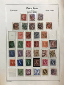
SoldHERMAN MOLL HAND COLORED ENGRAVED MAPS 18TH C. TWOHERMAN MOLL, HAND COLORED ENGRAVED MAPS, 18TH C., TWO, GREAT BRITAIN, IRELAND, GALLOWAY:Under glass and matted in matched frames. Lyons Ltd., Antique Prints label. Visible image size 7 3/4" x 10 1/4".See Sold Price
HERMAN MOLL HAND COLORED ENGRAVED MAPS 18TH C. TWOHERMAN MOLL, HAND COLORED ENGRAVED MAPS, 18TH C., TWO, GREAT BRITAIN, IRELAND, GALLOWAY:Under glass and matted in matched frames. Lyons Ltd., Antique Prints label. Visible image size 7 3/4" x 10 1/4".See Sold Price
SoldHerman Moll, Map of Scotland, 1714Property of a Private Collection, Savannah, GA (British, 1654?-1732), The North Part of Great Britain Called Scotland, 1714, engraved map with outline color, matted and framed. Frame size: 32 1/2 in.See Sold Price
Crams Railroad Map of New York-1881JM Hobby Supply and Railroad Artifact Auctions4.4(126)See Sold PriceFeb 24, 2024
LATE 18TH C. VERY LARGE CHART OF NORTHEAST CANADA BY DES BARRES (1721-1824), 1780, FRAMEDThomaston Place Auction Galleries4.4(386)See Sold PriceFeb 24, 2024
LARGE LATE 17TH C. DUTCH CHART OF CANADA, GREAT LAKES, NEW FRANCE, LABRADOR, HUDSON BAY, BY PIERREThomaston Place Auction Galleries4.4(386)See Sold PriceFeb 24, 2024
LATE 17TH C. FRENCH MAP OF THE NEW WORLD BY ALEXIS-HUBERT JAILLOT (1632-1712)Thomaston Place Auction Galleries4.4(386)See Sold PriceFeb 24, 2024
BOTH TITLE PAGES OF COLLINS" COASTAL SURVEY, 1776, IN MATCHING FRAMESThomaston Place Auction Galleries4.4(386)See Sold PriceFeb 24, 2024
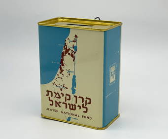
Jewish National Fund Collection Box - Great BritainLevy Auction House4.4(11)See Sold PriceFeb 27, 2024
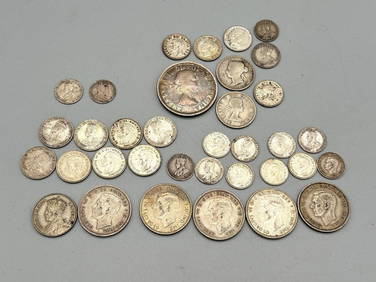
Group of Canada, New Zealand, Australia, Great Britain Silver CoinsDana J. Tharp Auctions4.6(255)See Sold PriceFeb 24, 2024
H.M. Of Great Britain "Advancing with Mistletoe"Old Toy Soldier Auctions USA4.8(1.1k)See Sold PriceMar 15, 2024
[MAP]. [ALBRIZZI, Giambatista, 1698-1777]. Carta Geografica...Potter & Potter Auctions4.6(538)See Sold PriceMar 07, 2024
Donovan's The Natural History of British Shells - 5 Volumes in 3 Books with 180 EngravingsTrillium Antique Prints & Rare Books4.5(28)See Sold PriceFeb 24, 2024
Audubon - 8 Quadruped LithographsTrillium Antique Prints & Rare Books4.5(28)See Sold PriceFeb 24, 2024
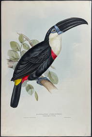
Gould - Natterer's Aracari or ToucanTrillium Antique Prints & Rare Books4.5(28)See Sold PriceFeb 24, 2024
EDWARD MCKNIGHT KAUFFER (1890-1954) SOARING TO SUCCESS! DAILY HERALD - THE EARLY BIRD. Circa 1973.Swann Auction Galleries4.4(64)See Sold PriceFeb 29, 2024
Herman Moll A New Map of Ye North Parts of AmericaWillow Auction House4.5(280)See Sold PriceMar 14, 2024


![[MAP]. [ALBRIZZI, Giambatista, 1698-1777]. Carta Geografica... (1 of 1)](https://p1.liveauctioneers.com/928/318880/171361280_1_x.jpg?height=282&quality=70&version=1707501302)