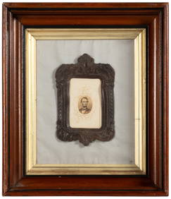
[Henri Abraham CHATELAIN] Nouvelle Carte de L’IrlandeFrom Atlas Historique, by H. A. Chatelain, 1718. Nouvelle Carte de L'Irlande, Hand-coloured maps. Map of the whole of Ireland (43 x 52 cm.) with two smaller maps. Some damp soiling, else good and cleaSee Sold Price
SoldHenri Abraham Chatelain MapHenri Abraham Chatelain, "Nouvelle Carte de l'Amerique Septentrionale...", Amsterdam, 1720, hand-colored engraved map from Atlas Historique, 18 3/4 in. x 23 1/8 in., unframedSee Sold Price
SoldHenri Abraham Chatelain 1720Henri Abraham Chatelain, "Nouvelle Carte de l'Amerique Septentrionale...", Amsterdam, 1720, hand-colored engraved map from Atlas Historique, 18 3/4 in. x 23 1/8 in., unframedSee Sold Price
SoldNouvelle Carte de l'Asie, avec des Tables AlphabetHenri Abraham Chatelain, Nouvelle Carte de l'Asie, avec des Tables Alphabetiques pour trouver sans peine les Etats des principaux..., engraving, 18th century , 23 x 18.5 23 x 18.5See Sold Price
[maps] Chatelain, Nouvelle carte de la sphereHenri Abraham Chatelain, Nouvelle carte de la sphere pour faire connoitre les divers mouvemens des planetes. 1708-1721. Incisione in rame. mm 515x600. Foglio: mm 550x645. Titolo impresso in altoSee Sold Price
SoldHenri Abraham Chatelain (1684-1783), "Nouvelle Carte deHenri Abraham Chatelain (1684-1783), "Nouvelle Carte de l'Amerique Septentrionale Dressee sur Les Plus Nouvelles Observations," 1710, H. - 19 in., W. - 24 in.See Sold Price
Chatelain, Henri Abraham. Nouvelle Carte de l' AsieChatelain, Henri Abraham Nouvelle Carte de l'Asie, avec des Tables Alphabetiques pour Trouver É 1705 Copperplate engraving; area coloured Printed area: 58.4 x 46.3 cm; 22.9 x 18.2 in Taken from ChateSee Sold Price
SoldChatelain (Henri Abraham) Nouvelle Carte de l'AmerChatelain (Henri Abraham) Nouvelle Carte de l'Amerique Septentrionale,North America including the West Indies and Central America, central and western regions blank, California apparently peniSee Sold Price
SoldChatelain (Henri Abraham) - Nouvelle Carte de l'Asie,"avec des Tables Alphabetiques pour trouver sans peine les Etats des Principaux Princes de cette partie du Monde", the continent of Asia from Lapland, Greece and Ethiopia to Japan, New Guinea and the nSee Sold Price
SoldChâtelain (H A) ScandinavieChâtelain (Henri Abraham) Nouvelle Carte de Scandinavie ou des Etats du Nord,Scandinavia with part of Russia and eastern Europe, bordered with numerous coats-of-arms, engraved map with explanaSee Sold Price
SoldA Detailed Map of Poland and the Baltic,c.1710, printed in Paris, Henri Abraham Chatelain (1684-1743), title reads 'Nouvelle Carte Du Royaume De Pologne, Divisee Selon Ses PaLatinates Et Ses Provinces, Avec Des Remarques Historiques . . .'See Sold Price
Sold[maps] Chatelain, Carte de la nouvelle FranceHenri Abraham Chatelain, Carte de la nouvelle France. 1708-1721. Incisione in rame. mm 425x500. Foglio: mm 445x550. Titolo impresso nel margine superiore dell'incisione. La carta mostra i territoSee Sold Price
Sold[Châtelain (H A)] Carte ...de Dannemarck[Châtelain (Henri Abraham)] Nouvelle Carte Geographique du Royaume de Dannemarck avec une table des villes les plus remarquables,Denmark with southern Sweden and the north German coast, with sSee Sold Price
Chatelain (H.A.) Nouvelle Carte... de LondresChatelain (Henri Abraham) Nouvelle Carte du Gouvernement Civil d'Angleterre; Nouvelle Carte d'Ecosse,the former of England and Wales, with two allegorical scenes in upper corners, and centralSee Sold Price
SoldChatelain (H.A.) Nouvelle Carte... de LondresChatelain (Henri Abraham) Nouvelle Carte du Gouvernement Civil d'Angleterre et de Celuy de la Ville de Londres,central plan of London, map of England and Wales above, two allegorical scenes inSee Sold Price
SoldHenri Abraham Chatelain (1684-1743)Henri Abraham Chatelain (1684-1743), "Carte de la Nouvelle France, ou se Voit le Cours des Grandes Rivieres de S. Laurens & de Mississipi... de la Floride, de la Louisiane, de la Virginie, de la MarieSee Sold Price
Chatelain map of North America 1705 hand-coloredTitle: Nouvelle Carte de l'Amerique Septentrionale Dressee sur les Plus Nouvelles Observation... Author: Chatelain, Henri Abraham Description: Copper-engraved map, later hand-coloring. 47x59.4 cm. (18See Sold Price
SoldChatelain map of North America 1705 hand-coloredTitle: Nouvelle Carte de l'Amerique Septentrionale Dressee sur les Plus Nouvelles Observation... Author: Chatelain, Henri Abraham Description: Copper-engraved map, later hand-coloring. 47x59.4 cm. (18See Sold Price
SoldIndia.- Chatelain (Henri Abraham) Carte Nouvelle desIndia.- Chatelain (Henri Abraham) Carte Nouvelle des Terres de Cucan, de Canara, de Malabar, de Madura, et de Coromandel..., map of southern India, extending north to Goa, surrounded with text and tabSee Sold Price
Chatelain (Henri Abraham) IndiaChatelain (Henri Abraham) Carte Nouvelle des Terres de Cucan, de Canara, de Malabar, de Madura, et de Coromandel,India south of Goa, with panels of text and tables to the right, and lower leftSee Sold Price
Sold* CHATELAIN, Henri Abraham. Carte de la Nouvelle* CHATELAIN, Henri Abraham (1684-1743). Carte de la Nouvelle France: oú se voit le cours des Grandes Rivieres de S. Laurens & de Mississipi. [Amsterdam, 1719]. Engraved map of the Mississippi River aSee Sold Price
SoldCHATELAIN, HENRI ABRAHAM. Carte de la NouvelleCHATELAIN, HENRI ABRAHAM. Carte de la Nouvelle France. Double-page engraved map, 430x500 mm, ample margins; hand-colored. Amsterdam, 1719 first edition, first state, appearing in Guedeville's Atlas HiSee Sold Price
SoldCHATELAIN, HENRI ABRAHAM. Carte de la NouvelleCHATELAIN, HENRI ABRAHAM. Carte de la Nouvelle France. Double-page engraved map, 425x500 mm, ample margins. McCorkle 719.4. Amsterdam, 1719 All items are offered for sale subject to Swann Galleries'See Sold Price
Chatelain, Henri Abraham. Carte de la Nouvelle FranceChatelain, Henri Abraham Carte de la Nouvelle France, o se voit le cours des Grandes Rivieres de S.Laurens & de Mississipi É 1718 Copperplate engraving; old coloured Printed area: 50 x 42.5 cm; 19.7See Sold Price
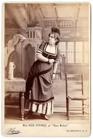
Cabinet Photo -Rose Eytinge - Jewish Actress - NY, 1870Levy Auction House4.3(11)See Sold PriceFeb 27, 2024
Henri de Toulouse-Lautrec (French) lithograph, titled "May Milton", circa 1895. Signed lower leftNeely Auction4.6(224)See Sold PriceFeb 25, 2024
Paul Cezanne (After) - Etude pour un Joueur de CarteDane Fine Art Auctions4.4(494)See Sold PriceMar 16, 2024
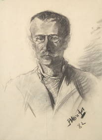
Henri de Toulouse-Lautrec (French, 1864-1901) - Portrait of Amédée Tapie de CéleyranFreeman's | Hindman4.5(158)See Sold PriceFeb 27, 2024
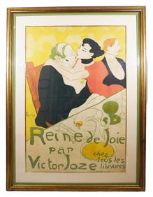
Henri De Toulouse-Lautrec "La Reine de Joie" LithographNapoleon's Fine Art4.4(75)See Sold PriceFeb 25, 2024
[MAPS]. DUFOUR, Auguste-Henri (1795-1865). Bound Volume of ...Potter & Potter Auctions4.6(539)See Sold PriceMar 07, 2024
[BASEBALL CARTE DE VISITE]. Carte de Visite Photograph of a...Potter & Potter Auctions4.6(539)See Sold PriceMar 07, 2024
[BASEBALL CARTE DE VISITE]. Carte de Visite Photograph of F...Potter & Potter Auctions4.6(539)See Sold PriceMar 07, 2024
[LINCOLN, Abraham (1809-1865), subject]. [BRADY, Matthew (1...Potter & Potter Auctions4.6(539)See Sold PriceMar 07, 2024
Chatelain - Map of the Americas and Details and Insets of Government CounselsTrillium Antique Prints & Rare Books4.5(30)See Sold PriceFeb 24, 2024
Chatelain - 3 Maps of the British Isles (England, Ireland, Scotland)Trillium Antique Prints & Rare Books4.5(30)See Sold PriceFeb 24, 2024
1758 MAP PARTIE DE LA MER GLACIALE contenants La Nouvelle Zemble RUSSIA antiqueJasper524.5(9.8k)See Sold PriceFeb 27, 2024


![[Henri Abraham CHATELAIN] Nouvelle Carte de L’Irlande First Image](https://p1.liveauctioneers.com/1187/57305/28080704_1_x.jpg?height=282&quality=95&version=1403622104&width=282)
![[Henri Abraham CHATELAIN] Nouvelle Carte de L’Irlande (1 of 1)](https://p1.liveauctioneers.com/1187/57305/28080704_1_x.jpg?height=282&quality=70&version=1403622104)
![[Henri Abraham CHATELAIN] Nouvelle Carte de L’Irlande First Image](https://p1.liveauctioneers.com/1187/57305/28080704_1_x.jpg?height=282&quality=1&version=1403622104&width=282)


![[maps] Chatelain, Nouvelle carte de la sphere (1 of 1)](https://p1.liveauctioneers.com/1306/122788/62497213_1_x.jpg?height=282&quality=70&version=1527839290)


![[maps] Chatelain, Carte de la nouvelle France (1 of 1)](https://p1.liveauctioneers.com/1306/122788/62497198_1_x.jpg?height=282&quality=70&version=1527839290)
![[Châtelain (H A)] Carte ...de Dannemarck (1 of 1)](https://p1.liveauctioneers.com/410/10165/2289159_1_x.jpg?height=282&quality=70)


![[MAPS]. DUFOUR, Auguste-Henri (1795-1865). Bound Volume of ... (1 of 2)](https://p1.liveauctioneers.com/928/318880/171361279_1_x.jpg?height=282&quality=70&version=1707501302)
![[BASEBALL CARTE DE VISITE]. Carte de Visite Photograph of a... (1 of 2)](https://p1.liveauctioneers.com/928/318880/171361405_1_x.jpg?height=282&quality=70&version=1707501302)
![[BASEBALL CARTE DE VISITE]. Carte de Visite Photograph of F... (1 of 2)](https://p1.liveauctioneers.com/928/318880/171361408_1_x.jpg?height=282&quality=70&version=1707501302)
![[LINCOLN, Abraham (1809-1865), subject]. [BRADY, Matthew (1... (1 of 1)](https://p1.liveauctioneers.com/928/318880/171361543_1_x.jpg?height=282&quality=70&version=1707501302)