Sold(HAWAII) A group of three maps of Hawaii, 1878.(HAWAII) A group of three maps of Hawaii and the Pacific region. Kauai. Government Survey. 1878. Washington: The Morris Peters Co., n.d. The Pacific Ocean, including Oceana. Thomas Cowperthwait,See Sold Price
Group of Three Maps, consisting of "Hawaii," 1905, byGroup of Three Maps, consisting of "Hawaii," 1905, by Rand McNally, matted and shrink wrapped; "Louisiana," by J. H. Colton, 1855, hand colored, matted and shrink wrapped; and "United States SouthernSee Sold Price
SoldGroup of Three Maps, consisting of "Hawaii," 1905, byGroup of Three Maps, consisting of "Hawaii," 1905, by Rand McNally, matted and shrink wrapped; "Louisiana," by J. H. Colton, 1855, hand colored, matted and shrink wrapped; and "United States SouthernSee Sold Price
Sold[AMERICANA] HAWAII MAP Lanai. Government Survey. 1[AMERICANA] HAWAII MAP Lanai. Government Survey. 1878.[Hawaiian Government Survey:] March 1900. Colored map of the island of Kauai. Condition: folds, some browning, perforated stamps of Free LSee Sold Price
SoldHawaii Antique Maps - Framed Set of 3 (125100)A set of three framed maps of Hawaii, also called the Sandwich Islands, pre-statehood. Professionally mounted, exquisitely matted (see photos), and framed -- two with glass, one without. Largest is frSee Sold Price
Sold1878 Survey Map Of Lanai, Hawaii1878 Government Survey map of Lanai, Hawaii traced by H. E. Newton in September , 1905 and reissued. Very good condition with minor fold wear.See Sold Price
SoldThree 1935 A Hawaii $1 Silver Certificates VG-FA group of three (3ct.) 1935 A Hawaii $1 Silver Certificates VG-F.See Sold Price
SoldCircle of Itaro Morihiro (born 1889) Eruption of Kīlauea, Hawaii Volcanoes National Park (a...Circle of Itaro Morihiro (born 1889) Eruption of Kīlauea, Hawaii Volcanoes National Park (a group of three) one marked 'COPY RIGHT 1919 / PHOTO BY I MORIHIRO / HILO T H 5' (lower left) handcoloreSee Sold Price
SoldA Group of Seven Blue Hawaii Promotional Leis,A Group of Seven Blue Hawaii Promotional Leis, three with original cardboard buttons, together with a photograph of Gary and the Tankers outside the premier for Blue Hawaii wearing the novelty leis, cSee Sold Price
SoldGroup of Three Geography BooksGroup of Three Geography Books. Includes: Harper's School Geography 1878; Modern Geography 1866; and Colton's Common School Geography. All illustrated with maps. Approximately 12" x 10.5" each. ProvenSee Sold Price
Sold1855 Colton Map of Hawaii, New Zealand, Oceania IslandsTitle/Content of Map: 1855 Colton Map of Hawaii, New Zealand, Oceania Islands -- Hawaii or Sandwitch Islands [with] Samoan.. [with] New Zealand [with] Viti Group or Feejee Islands [with] Societi IslanSee Sold Price
SoldKauai, Hawaii brochure with map 1927Heading: (Hawaii) Author: Title: Don't Miss Kauai, the garden island of the Hawaiian group Place Published: Honolulu Publisher:Hawaii Tourist Bureau Date Published: 1927 Description: <See Sold Price
Kauai, Hawaii brochure with map 1927Heading: (Hawaii) Author: Title: Don't Miss Kauai, the garden island of the Hawaiian group Place Published: Honolulu Publisher:Hawaii Tourist Bureau Date Published: 1927 Description: <See Sold Price
Sold1898 1ed Hawaii & Japan VOLCANOS California Illustrated1898 1ed Hawaii & Japan VOLCANOS California Illustrated MAP Waikiki Kendo In his book ‘Vacation Days in Hawaii and Japan’, Charles Taylor describes his three-month tour of Japan and Hawaii with deSee Sold Price
Group of Three Hawaii Prints by John Melville Kelly1879-1962 framed under glass. Frames: 48 x 38cm (18.9 x 15in), sights: 33 x 23cm (13 x 9in)See Sold Price
Large Map of Lanai With DetailWall, Walter E. & Newton, H. E. Lanai Government Survey 1878... Lithographed map. Hawaii Territory Survey, 1906. 19 ½" x 26 ¼" sheet. Walter E. Wall, surveyor. Triangulation, Topography, BoundarSee Sold Price
SoldNewton: Antique Map of Lanai Hawaii in 1878Map: Lanai 1878 Publication Date: 1906-09-01 Cartographer: Newton, H. E/J. F. Brown/M. D. Monsarrat Publisher: Hawaiian Government Survey Size: Elephant Folio – 19.60 H x 26.25 W Inches Detailed topSee Sold Price
SoldA Group of Three Maps, Largest 19 x 22 1/4 inchesA Group of Three Maps, each handcolored, unframed. Largest 19 x 22 1/4 inches.See Sold Price
SoldGroup of three maps to include framed Magna BritanniaGroup of three maps to include framed Magna Britannia Complectens Angliae scotiae......Bapt. Homann and two unframed, Hampshire unframed map, regulated by Astron observations by T Kitchin, improved maSee Sold Price
SoldGroup of Three Maps by Nicolas Sanson (1600-1667,Group of Three Maps by Nicolas Sanson (1600-1667, Paris), "La Gaule en dixsept provinces Romain," 1641; together with "Gouvernment General du Lyonnois, Forez, Beavoilais," 1679; and "Gouvernment De FrSee Sold Price
SoldGroup of Three Maps by Antonio Zatta (1757-1797,Group of Three Maps by Antonio Zatta (1757-1797, Venice), consisting of "L'Esremadura a la Castiglia Nuova," 1776; "Andalusia e Granada," 1776; and "La Catalogna Li Regni Di Aragona ed Alta Navarra,"See Sold Price
A Group of Three Maps by John Gibson, 18th Century,A Group of Three Maps by John Gibson, 18th Century, Including 'A Map of 100 Miles Round Boston', 'A Map of the Icy Sea in with the Land Waters and Others', and 'The British Government in North AmericaSee Sold Price
SoldGroup of Three MapsGroup of Three Maps Three engraved maps with hand-coloring including: La Principaute D'Orange; Carte Geometrique des Environs de l'Etang de Long; and Mer Oceane. All approximately 18 x 22 1/2 in. (sheSee Sold Price
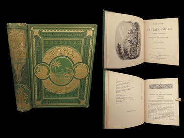
1789 Captain James Cook Life & Voyages Australia New Zealand Hawaii KippisSchilb Antiquarian Rare Books4.8(431)See Sold PriceMar 10, 2024
1871 Captain Cook Voyages Around the World Tahiti Hawaii Exploration AntarcticaSchilb Antiquarian Rare Books4.8(431)See Sold PriceMar 10, 2024
Group of Three Wadhams Mobil Road MapsCheck the Oil Promotions, LLC4.6(346)See Sold PriceFeb 25, 2024
Three Peices of 1800s / Early 1900s Railroad Ephemera Pieces - Boston and Maine, Boston & NorthernRail & Road Auctions4.6(165)See Sold PriceMar 08, 2024
Four White Pass & Yukon Route Playing Card DecksRail & Road Auctions4.6(165)See Sold PriceMar 08, 2024
8 Stereoscope Cards - The Government House in Hawaii, Niagra Falls, SceneryNorth American Artifact Auctions4.7(201)See Sold PriceApr 20, 2024
Group of 4 - 1934A Hawaii Emergency CurrencyMatthew Bullock Auctioneers4.7(1.9k)See Sold PriceFeb 24, 2024
Vaillant - Hawaii: Stranding in the Sandwich Islands (Echouage aux Iles Sandwich). 43Trillium Antique Prints & Rare Books4.5(33)See Sold PriceFeb 24, 2024
Vaillant - Kealakekua Bay, Hawaii (Village de Kearakekoua, Iles Sandwich). 44Trillium Antique Prints & Rare Books4.5(33)See Sold PriceFeb 24, 2024
Vaillant - Honolulu, Hawaii (Vue de Honolulu, Iles Sandwich). 45Trillium Antique Prints & Rare Books4.5(33)See Sold PriceFeb 24, 2024
Vintage Faraone 18k Gold Coin Necklace Gunmetal Italy Estate JewelryJasper524.5(9.9k)See Sold PriceFeb 27, 2024
West Indies Islands. Guadaloupe. | Mariegalante &C. | Antigua.Jasper524.5(9.9k)See Sold PriceFeb 27, 2024
Alfred Salzman, Etc. JNF Tin Tzedakah Boxes, 3Auctions at Showplace4.6(744)See Sold PriceApr 07, 2024


![[AMERICANA] HAWAII MAP Lanai. Government Survey. 1 (1 of 0)](https://p1.liveauctioneers.com/dist/images/placeholder.jpg?height=282&quality=70)