SoldHANDCOLORED "MAP OF NORTH & SOUTH CAROLINA BY H.S.HANDCOLORED "MAP OF NORTH & SOUTH CAROLINA BY H.S. TANNER". Engraved and published in Philadelphia, August 20, 1823, by Henry Schenck Tanner with the heading for the "American Atlas". Good color and sSee Sold Price
Sold19th Century Map of the Carolinas[Map of North & South Carolina], by H.S. Tanner, from Tanner's [New American Atlas...], Philadelphia, 1823, demarcated counties, key listing forts, battlegrounds, other points of interest, "American ASee Sold Price
SoldAntique Johnson's Map of North & South Carolina.Antique Johnson's Map of North & South Carolina. An engraved, hand-colored map of North and South Carolina, printed by Johnson and Ward. Most likely the 1866 edition, based on the vignettes, the smallSee Sold Price
SoldJohnson's North and South Carolina Map, 1866partially hand-colored map of North and South Carolina and the surrounding areas with three insets: Chimney Rocks and the French Broad River, Table Mountain, and a Plan of Charleston, with Johnson's tSee Sold Price
SoldMAP OF NORTH AND SOUTH CAROLINA 1825 REPRINTVintage Reprint Map of North and South Carolina 1825 by H.S. Stanner. Reprint was published in Kitty Hawk NC in 1967 by Lewis & Clark Explorer Map Ltd. Professionally framed and matted, measures 21 3/See Sold Price
Sold1865 JOHNSON'S NORTH & SOUTH CAROLINA MAP1865 JOHNSON'S NORTH & SOUTH CAROLINA MAP: Hand colored map, published 1865 by A. J. Johnson, New York. Insets of Table Mountain, Chimney Rocks & French Broad River, and Charleston Harbor. Sight sizeSee Sold Price
Sold*MORTIER, PIERRE2 handcolored antiquarian maps ca. 1698, Carte General of North and South Carolina, both artist identified in plate, approximate sheet size of each 23" x 19".See Sold Price
Thomas Kitchen map of Southeastern America BritishThomas Kitchen map of Southeastern America British (1718-1784) "A New Map of North & South Carolina & Georgia" hand-colored engraving. paper size: H8 1/4" W11 1/4"See Sold Price
Mitchell: Antique Map of North & South Carolina, 1869Title/Content of Map: North & South Carolina by Mitchell Date Printed: 1869 Cartographer: Augustus S. Mitchell Material/Medium: Paper Size: 15 1/3" x 12 1/2" Hand colored steel engraved Map. PublishedSee Sold Price
Sold1865 A.J. Johnson Map of North & South Carolina,handcolored, image area approx. 17" x 23".See Sold Price
Sold19th C. Map of North & South CarolinaEach county individually hand colored; unframed; 14 1/2"W, 12"H; small tears to margins well outside border and map, toningSee Sold Price
SoldJohnson’s Civil War era map of North & South CarolinaHistoric map shows the Carolinas in great detail shortly following the outbreak of the Civil War. States hand-colored at the time of publishing with color coding according to county. Inset map depictsSee Sold Price
SoldMap, Johnson's North & South Carolina,Johnson and Ward, hand colored inset views of "Chimney Rocks and French Broad River", "Table Mountain", and "Plan of Charleston, Vicinity and Harbor", 1860-1870, 17-3/8 x 24 in. (sight); professionallSee Sold Price
SoldCollection of 12 hand-colored maps from Johnson'sLithographed. With: The World (in Hemispheres); North America; California with New Mexico and Utah (2 copies); Delaware and Maryland (2 copies); Iowa and Nebraska (2 copies); North and South CarolinaSee Sold Price
Sold1884 Mitchell Map of North & South CarolinaEach county individually hand colored; insets of Charleston Harbor and detailed map of the Plan of Charleston; unframed; 14"W, 11 1/2"H--Private collection, Spartanburg, South CarolinaSee Sold Price
Sold1881 Mitchell Map of North & South CarolinaEach county individually hand colored; insets of Charleston Harbor and detailed map of the Plan of Charleston; matted and under glass in black painted wood frame; sight 14 1/2"W, 12"H; frame 17 3/4"W,See Sold Price
Johnson: Civil War Era Map of North & South CarolinaJohnson’s Civil War era map of North & South Carolina. Historic map shows the Carolinas in great detail shortly following the outbreak of the Civil War. States hand-colored at the time of publishingSee Sold Price
North Carolina & South Carolina by MitchellTitle/Content of Map: North Carolina & South Carolina by Mitchell Date Printed: 1869 Cartographer: Augustus S. Mitchell Material/Medium: Paper Size: 14" x 16" Provenance: New York Hand colored engraveSee Sold Price
SoldJohnson’s Map Of North And South Carolinahand colored inset views of "Chimney Rocks and French Broad River", "Table Mountain", and "Plan of Charleston, Vicinity and Harbor",See Sold Price
SoldMap, "Johnson's North and South Carolina,"Map, "Johnson's North and South Carolina," (New York: Johnson & Ward, ca. 1860s), hand colored steel engraving from folio, fine details showing major roads and railroads, three insets include map of CSee Sold Price
Sold1825 Map of North and South Carolina, GeorgiaEngraved and published by N. & S. S. Jocelyn, New Haven, Connecticut, 1825; hand colored areas; unusual circular inset "Charleston and its Vicinity" extends to include Johns, James and Daniels IslandsSee Sold Price
SoldEarly map of the Carolinas by Henry MouzonEarly map of the Carolinas by Henry Mouzon AN ACCURATE MAP OF NORTH AND SOUTH CAROLINA WITH THEIR INDIANFRONTIERS.......FROM ACTUAL SURVEYS BY HENRY MOUZON AND OTHERS; engraving withhandcolored highliSee Sold Price
SoldMOUZON, HENRY. An Accurate Map of North and SoMOUZON, HENRY. An Accurate Map of North and South Carolina. Engraved 4-sheet map, with horizontal sheets joined to make 2, 1055x1445 mm overall; hand-colored in outline; dampstained and with soot andSee Sold Price
SoldFINLEY, ANTHONY. Map of North and South CaroliFINLEY, ANTHONY. Map of North and South Carolina and Georgia. Hand-colored engraved pocket map, 430x545 mm sheet size, margins slightly trimmed with imprint along bottom edge partially shaved; removedSee Sold Price
Portfolio of 15 County Maps by Robert Morden (English 1650-1703)Nadeau's Auction Gallery4.7(409)See Sold PriceFeb 24, 2024
[ARCTIC]. BOWEN, Emanuel. A New & Accurate Map of the North...Potter & Potter Auctions4.6(545)See Sold PriceMar 07, 2024
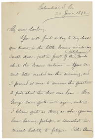
[ENSLAVEMENT & ABOLITION]. Letter from a southern slave trader describing the transportation ofFreeman's | Hindman4.4(1.6k)See Sold PriceFeb 27, 2024
Carey, pub. 1796 - Map of The State of South CarolinaTrillium Antique Prints & Rare Books4.5(32)See Sold PriceFeb 24, 2024
Carey, pub. 1796 - Map of the Tennassee State formerly part of North Carolina (Tennessee)Trillium Antique Prints & Rare Books4.5(32)See Sold PriceFeb 24, 2024
Map: An 18thC engraved and hand coloured map of North America and South America, titled DeClaydon Auctioneers Ltd4.3(125)See Sold PriceFeb 26, 2024
1822 MAP of NORTH & SOUTH AMERICA GEOGRAPHICAL STATISTICAL HISTORICAL antiqueJasper524.5(9.9k)See Sold PriceFeb 27, 2024
Blackie (Pub) 1882 Pair of Folio Maps. Italy - North & SouthAlbion Auctions4.6(341)See Sold PriceMar 01, 2024
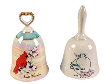
Vintage North And South Carolina Souvenir Porcelain BellsRapid Estate Liquidators and Auction Gallery4.5(1.1k)See Sold PriceMar 02, 2024


![[ARCTIC]. BOWEN, Emanuel. A New & Accurate Map of the North... (1 of 1)](https://p1.liveauctioneers.com/928/318880/171360917_1_x.jpg?height=282&quality=70&version=1707501302)
![[ENSLAVEMENT & ABOLITION]. Letter from a southern slave trader describing the transportation of (1 of 3)](https://p1.liveauctioneers.com/197/319238/171468031_1_x.jpg?height=282&quality=70&version=1707520367)