SoldGuiljelmum Blaeu Map, Copper Engraving, c. 1640[Blaeu Map of Burgundy], "Utriusque Burgundiae, tum Ducatus tum Comitalus", by Guiljelmum Blaeu, Amsterdam, c. 1640, copper engraving, later color, framed and matted, lacking glass * NO RETURNS ARE ACSee Sold Price
SoldGuiljelmum Blaeu Map of Germany, Copper Engraving[Blaeu Map of Germany] Wirtenberg Ducatus (Duchy of Wurttemburg), c. 1650, from Blaeu's atlas "Theatrum Orbis Terrarum", hand-colored copper engraving, with decorative title cartouche and coat-of-armsSee Sold Price
SoldBlaeu map of Cyprus c.1640Heading: Author: Blaeu, Willem Title: Cyprus Insula Place Published: Amsterdam Publisher: Date Published: c.1640 Description: Copper-engraved map, hand-colored in outline,See Sold Price
SoldBlaeu map of the Caribbean c.1640Heading: Author: Blaeu, Willem Title: Insulae Americanae in Oceano Septentrionali, cum Terris Adiacentibu Place Published: Amsterdam Publisher: Date Published: c.1640 Description:See Sold Price
SoldBlaeu map of Greece c.1640Heading: Author: Blaeu, Johann & Cornelius Title: Graecia Place Published: Amsterdam Publisher: Date Published: c.1640 Description: Copper-engraved map, hand-colored in outSee Sold Price
SoldBlaeu map of Scandinavia 1640Heading: Author: Blaeu, Willem Title: Suecia, Dania, et Norvegia, Regna Europae Septentrionalia... Place Published: Amsterdam Publisher: Date Published: c.1640 Description:See Sold Price
SoldBlaeu map of western Holland.Heading: Author: Blaeu, Willem Title: Hollandia Comitatus Place Published: Amsterdam Publisher: Date Published: c.1640 Description: Copper-engraved map, hand-colored. 39x52See Sold Price
Blaeu map of Cyprus c.1640Heading: Author: Blaeu, Willem Title: Cyprus Insula Place Published: Amsterdam Publisher: Date Published: c.1640 Description: Copper-engraved map, hand-colored in outline,See Sold Price
Blaeu map of Guiana and Amazon, c.1640Heading: Author: Blaeu, Willem Title: Guiana sive Amazonum Regio Place Published: Amsterdam Publisher: Date Published: c.1640 Description: Copper-engraved map, hand-coloredSee Sold Price
SoldBlaeu map of Macedonia c.1640Heading: Author: Blaeu, Willem Title: Macedonia, Epirus et Achaia Place Published: Amsterdam Publisher: Date Published: c.1640 Description: Copper-engraved map, hand-coloreSee Sold Price
Blaeu map of Macedonia c.1640Heading: Author: Blaeu, Willem Title: Macedonia, Epirus et Achaia Place Published: Amsterdam Publisher: Date Published: c.1640 Description: Copper-engraved map, hand-coloreSee Sold Price
SoldBlaeu map of England & Wales 1640Heading: Author: Blaeu, Willem Title: Anglia Regnum Place Published: Amsterdam Publisher: Date Published: c.1640 Description: Copper-engraved map, hand-colored in outline,See Sold Price
SoldBlaeu map of northern France 1664Heading: (France) Author: Blaeu, Willem & Joan Title: Comitatus Bellovacum vernacule Beauvais Place Published: Amsterdam Publisher: Date Published: c.1640 Description: CoppeSee Sold Price
SoldBlaeu map of Bituricum, France, c.1640Heading: (France) Author: Blaeu, Willem Title: Bituricum Ducatus. Duche de Berri Place Published: Amsterdam Publisher: Date Published: c.1640 Description: Copper-engraved maSee Sold Price
SoldWillem Blaeu (Dutch, 1571-1638)Willem Blaeu (Dutch, 1571-1638), "Insulae Americanae in Oceano Septentrionali cum Terris adiacentibus", Amsterdam, c. 1640, hand-colored copper engraving, Dutch text, verso, 15 in. x 20 5/8 in., frameSee Sold Price
SoldBlaeu, historical map ofBlaeu, historical map of the Odenwald around Erbach ''Erpach comitatus'', (Erbach, Bergstrasse & Odenwald), altkol. Engraving near Blaeu in Amsterdam c. 1640, half-fold, browned, 36 x 48 cm, behind glSee Sold Price
SoldMap of southern Italy by Blaeu, c.1640Heading: Author: Blaeu, Willem Title: Terra di Otranto olim Salentina et Iapigia Place Published: Amsterdam Publisher: Date Published: c.1640 Description: Copper-engraved mSee Sold Price
SoldNorthern French province of Artois c.1640Title: Artesia Comitatus - Artois Author: Blaeu, Willem Description: Copper-engraved map, hand-colored in outline. 37x48 cm. (14½x19").Map of the northern French province of Artois on the border withSee Sold Price
SoldBlaeu's map of Europe with side vignettes, c.1640Title: Europa Recens Descripta Author: Blaeu, Willem Description: Copper-engraved map, hand-colored. 41x55 cm. (16x21½"), including vignette panels at sides and top. Blaeu's striking map of Europe, wSee Sold Price
SoldBlaeu map of Paraguay c.1640Title: Paraguay, O Prov. De Rio de la Plata cum regionibus adiacentibus Tucuman et Sta. Cruz de la Sierra Author: Blaeu, Willem Description: Copper-engraved map, hand-colored.37x48 cm. (14½x19").AttrSee Sold Price
Blaeu map of the Arctic regions c.1640Title: Regiones Sub Polo Arctico Author: Blaeu, Willem Description: Copper-engraved map, later hand-coloring with gold highlights. 41x53 cm. (16x21").The Arctic regions including Iceland, Nova Zemla,See Sold Price
SoldBlaeu map of the Arctic regions c.1640Title: Regiones Sub Polo Arctico Author: Blaeu, Willem Description: Copper-engraved map, later hand-coloring with gold highlights. 41x53 cm. (16x21").The Arctic regions including Iceland, Nova Zemla,See Sold Price
Blaeu map of Peru c.1640Title: Peru Author: Blaeu, Willem Description: Copper-engraved map, hand-colored. 37x48 cm. (14½x19").Peru with east at the top, sailing ships and a few sea monsters in the Pacific. Heading: zzcPlaceSee Sold Price
SoldThe Navarra region of Spain, c.1640Title: Navarra Regnum Author: Blaeu, Willem Description: Copper-engraved map, hand-colored in outline & wash; colored pictorial cartouche. 42x50 cm. (16½x19½").The Navarre region in northern Spain,See Sold Price
LATE 18TH C. VERY LARGE CHART OF NORTHEAST CANADA BY DES BARRES (1721-1824), 1780, FRAMEDThomaston Place Auction Galleries4.4(386)See Sold PriceFeb 24, 2024
LARGE LATE 17TH C. DUTCH CHART OF CANADA, GREAT LAKES, NEW FRANCE, LABRADOR, HUDSON BAY, BY PIERREThomaston Place Auction Galleries4.4(386)See Sold PriceFeb 24, 2024
EARLY 18TH C. DUTCH CHART OF PACIFIC OCEAN BY FREDERIK DE WIT (1629-1706) WITH CALIFORNIA AS ANThomaston Place Auction Galleries4.4(386)See Sold PriceFeb 24, 2024
LARGE EARLY 18TH C. DUTCH CHART OF UPPER NORTH AMERICA, PIERRE MORTIER (1661-1711), FRAMEDThomaston Place Auction Galleries4.4(386)See Sold PriceFeb 24, 2024
WILLEM JANSZOON BLAEU (NETHERLANDS, 1571-1638) MAP OF UMBRIAThomaston Place Auction Galleries4.4(386)See Sold PriceFeb 24, 2024
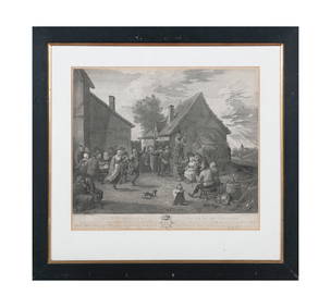
AFTER TENIERS, c.1797 'The Village Festival' Copper plate engraving, 44 x 50cm Together with; AfterAdam's Auctioneers4.3(5)See Sold PriceFeb 27, 2024
Johann Homann Hand-Colored Map Engraving, c. 1730Auctions at Showplace4.5(726)See Sold PriceMar 17, 2024
Willem Blaeu, Etc. 17th C. Antiquarian Maps, 2Auctions at Showplace4.5(726)See Sold PriceMar 17, 2024
Two (2) Antique 18th C. Copper Engraved Framed Maps - America & EuropeMagnusson Art Group4.5(46)See Sold PriceMar 14, 2024
1816 MAP SOUTHERN PART OF RUSSIA or MUSCOVY in EUROPE copper engraving ANTIQUEJasper524.5(9.8k)See Sold PriceFeb 27, 2024
1816 MAP NORTHERN PART OF RUSSIA or MUSCOVY in EUROPE copper engraving ANTIQUEJasper524.5(9.8k)See Sold PriceFeb 27, 2024
David Newton Fielding Duck Hunting c. 1840 Engraving SignedKCM Galleries4.7(164)See Sold PriceFeb 25, 2024