SoldGroup of Ten Double Sheet Atlas Maps of Europe, 1841,Group of Ten Double Sheet Atlas Maps of Europe, 1841, by J. Andriveau-Goujon, Paris, unframed, Each Sheet- H.- 27 1/2 in., W.- 20 1/2 in.See Sold Price
SoldGroup of Seventeen Double Sheet Atlas Maps of Europe,Group of Seventeen Double Sheet Atlas Maps of Europe, 18th c., by Robert de Vaugondy, unframed, Each- H.- 22 in., W.- 30 1/2 in.See Sold Price
SoldGroup of Fifteen Double Sheet Atlas Maps of Europe, 18tGroup of Fifteen Double Sheet Atlas Maps of Europe, 18th c., by Robert de Vaugondy, unframed, Each- H.- 22 in., W.- 30 1/2 in.See Sold Price
SoldCary (John) [A New Universal Atlas]Cary (John) [New Universal Atlas],a bound group of 20 double-page map sheets only, of 60 sheets listed in contents page, attached, lacking title, including Europe, Spain, Scotland in 4 sheets,See Sold Price
SoldGroup of Forty Five Maps from Black's General Atlas,Group of Forty Five Maps from Black's General Atlas, 1853, some double sheets, Single- H.- 17 1/4 in., W.- 10 3/4 in.See Sold Price
Sold(CELESTIAL.) Burritt, Elijah H. Group of 7 hand-colored(CELESTIAL.) Burritt, Elijah H. Group of 7 hand-colored engraved celestial charts. Folio sheets, one double-page; light foxing. – Hartford, 1835See Sold Price
SoldCHATELAIN, HENRI. Group of 28 double-page or foldingCHATELAIN, HENRI. Group of 28 double-page or folding plates from Atlas Historique, many with engraved figures, scenes, coins and tables. Folio sheets; condition generally fine. – Amsterdam, circSee Sold Price
Sold(MISCELLANEOUS MAPS.) Group of 10 double-page engraved(MISCELLANEOUS MAPS.) Group of 10 double-page engraved maps. European makers, 17th-18th centuries. - Vp, vd Ogilby/Montanus. Peru. 15½x17 inches sheet size, wide margins; hand-colored; age toningSee Sold Price
Sold(ASIA.) Group of 5 double-page engraved maps of the(ASIA.) Group of 5 double-page engraved maps of the continent. Vp, vd *Seutter, Matthaeus. Asia Cum Omnibus Imperiis, Provinciis, Statibus et Insulis. 20¼x23¼ inches sheet size, ample marginSee Sold Price
SoldORTELIUS, ABRAHAM. (Italy). Group of 3 double-pageORTELIUS, ABRAHAM. (Italy). Group of 3 double-page engraved maps. Extracted from one copy of Theatrum Orbis Terrarum; 17x21 inches each sheet size, wide margins, Latin text on verso; original hand-colSee Sold Price
Sold(HOLY LAND.) Fuller, Thomas. Group of 4 hand-colored(HOLY LAND.) Fuller, Thomas. Group of 4 hand-colored double-page engraved maps, from A Pisgah-Sight of Palestine. Approximately 13x15 inches each sheet size, wide margins; only minor flaws. - London,See Sold Price
SoldDE FER, NICOLAS. L'Empire des Turcs, en Europe, enDE FER, NICOLAS. L'Empire des Turcs, en Europe, en Asie, et en Afrique. Large double-page engraved map of the Turkish Empire. 21x29½ inches sheet size, wide margins; original hand-color in outlinSee Sold Price
Sold5 maps: West India Islands, Insulae Danicae...[Caribbean/Denmark/Central Europe] 5 Maps. Double-page. ++ West India Islands. 3 maps on 1 sheet: St. Christophers, St. Lucia, Nevis. “Engraved by Kirkwood & Son Edinburgh.” in margin. [C. 1810.]See Sold Price
SoldBLAEU, WILLEM. Europa Recens Descripta.BLAEU, WILLEM. Europa Recens Descripta. Double-page engraved map of Europe with carte-a-figures and city plan border panels. 17¾x23¾ inches sheet size, ample margins, Latin text on verso; niSee Sold Price
SoldMERCATOR, GERARD; and HONDIUS, JODOCUS. Europa.MERCATOR, GERARD; and HONDIUS, JODOCUS. Europa. Double-page engraved map of Europe. 18½x22 inches sheet size, wide margins, French text on verso; original hand-color; foxing and general age toninSee Sold Price
Sold9 Engravings incl: PLAN DU ROME, NAPLES.[Europe/Italy] 9 Engravings. ++ PLAN DE ROME, Par J. B. Nolli, en 1748. Double-page bird’s eye map. 14 ¼ x 9 ½ in. Tape to 3 points along edge of sheet and more locations near edges of its verso,See Sold Price
SoldMOLL, HERMAN. A New Map of the Baltick &c.MOLL, HERMAN. A New Map of the Baltick &c. Double-page engraved map of northern Europe centered on the Baltic Sea. 22x25¼ inches sheet size, wide margins; original hand-color in outline; originalSee Sold Price
Sold-. Johnston (Alexander Keith) A group of 25 Europe-. Johnston (Alexander Keith) A group of 25 European and World maps,double-page, engraved and hand-coloured in outline, sheet size c.495 x 610mm, Edinburgh & London, [c.1870]. ⁂See Sold Price
SoldMexican Border Atlas-1898.Atlas titled "Senate Document Vol 25, No 247, Mexican Boundary Commission Atlas, 55th Congress, 2nd Session 1897-1898", folio containing 26 double sheet maps, 1st edition. Atlas is bound in ¾ leatherSee Sold Price
Rand McNally New Business Atlas Map of Texas, 1895Map: Rand McNally & Co.'s New Business Atlas Map of Texas Publisher: Rand McNally & Co, Chicago Date: 1895 Size: Folio - 19 inches high x 26 inches wide Very large double sheet map. Railroads listed aSee Sold Price
SoldSoutheast Asia & Pacific Ocean.- Vandermaelen (PhilippeSoutheast Asia & Pacific Ocean.- Vandermaelen (Philippe Marie Guillaume) 31 double-page sheets from: Atlas 'Universel de geographie physique', including maps of Timor, Sumatra, Borneo, Java, New GuineSee Sold Price
Bradford: Map of Europe, 1841Map of Europe. Boynton, G. W., Goodrich, Samuel Griswold/ Thomas Gamaliel Bradford. Boston 1841. Detailed map of Europe and European Russia. Folio – 13.20 H x 16.50 W Inches Please note that this loSee Sold Price
CaliforniaPublication Date: c1891 Title: California Cartographer: CRAM, GEORGE F. Publisher: A.A. Grant Double sheet grid map from Grant's Bankers' and Brokers' railway system atlas. Railroads color coded. ShowSee Sold Price
SoldAdam Black, "Black's General Atlas of the World"Adam Black, "Black's General Atlas of the World" (Edinburgh, A. and C. Black 1872); contemporary half sheep over gilt printed buckram [panels detached]; 68 maps on double sheets, complete. Personal prSee Sold Price
A Group of Ten Chinese Embroidered Silk Border FragmentsNazmiyal Auctions4.4(36)See Sold PriceFeb 26, 2024
Group of Ten Books: Art of the Embroiderer, Charles Germain de Saint Aubin; Hand Weaving PatternsNazmiyal Auctions4.4(36)See Sold PriceFeb 26, 2024
RARE 1638 HONDIUS MAP OF BERMUDA, FRAMEDThomaston Place Auction Galleries4.4(394)See Sold PriceFeb 24, 2024
17TH C. MAP OF THE BERKSHIRES BY JOHN SPEED, FRAMEDThomaston Place Auction Galleries4.4(394)See Sold PriceFeb 24, 2024
WILLEM JANSZOON BLAEU (NETHERLANDS, 1571-1638) MAP OF UMBRIAThomaston Place Auction Galleries4.4(394)See Sold PriceFeb 24, 2024
MAP OF SALZBURG BY GEORGE BRAUN & FRANS HOGENBURG. 1588Thomaston Place Auction Galleries4.4(394)See Sold PriceFeb 24, 2024
Group of Ten Railroad Photographs, Maps, and Prints - New Jersey, Long Island, and New YorkRail & Road Auctions4.6(165)See Sold PriceMar 07, 2024
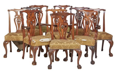
Group of Ten Antique Carved Mahogany Chippendale Chairs, 20th c., Arm Chairs- H.- 39 1/2 in., W.- 29Crescent City Auction Gallery4.3(233)See Sold PriceMar 01, 2024
Clayton Anderson (American, B. 1943) Ondine, Ten LithographsHoch LTD.4.6(80)See Sold PriceFeb 25, 2024
Two (2) Antique 18th C. Copper Engraved Framed Maps - America & EuropeMagnusson Art Group4.5(53)See Sold PriceMar 14, 2024
Carey, pub. 1796 - Map of KentuckyTrillium Antique Prints & Rare Books4.5(33)See Sold PriceFeb 24, 2024
Carey, pub. 1796 - Map of the Tennassee State formerly part of North Carolina (Tennessee)Trillium Antique Prints & Rare Books4.5(33)See Sold PriceFeb 24, 2024
10PC 1978 Kenner Star Wars Group incl. DT LukeBruneau & Co. Auctioneers4.5(491)See Sold PriceFeb 24, 2024
Group of Ten Blenko Glass Items, 20th c., Brown Decanter- H.- 16 1/4 in., Dia.- 4 1/4 in. (10 Pcs.)Crescent City Auction Gallery4.3(233)See Sold PriceMar 08, 2024
Mixed Group of Ten American Federal Carved Mahogany Dining Chair, early 19th c., Largest Armchair-Crescent City Auction Gallery4.3(233)See Sold PriceMar 09, 2024


![Cary (John) [A New Universal Atlas] (1 of 0)](https://p1.liveauctioneers.com/dist/images/placeholder.jpg?height=282&quality=70)