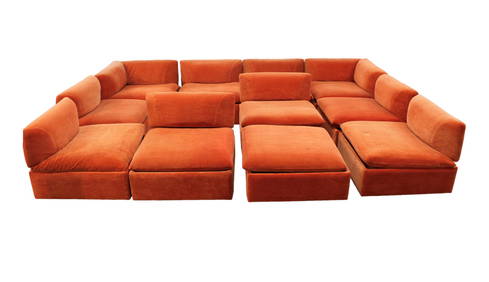
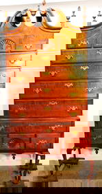
11pc. MCM Vintage Modular Sofa Set, removable backs, make up your own setting, desirable orangeSouth Jersey Auction by Babington Auction Inc4.6(124)See Sold PriceFeb 25, 2024
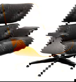
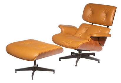
Charles & Ray Eames for Herman Miller Lounge ChairAuctions at Showplace4.6(740)See Sold PriceMar 03, 2024
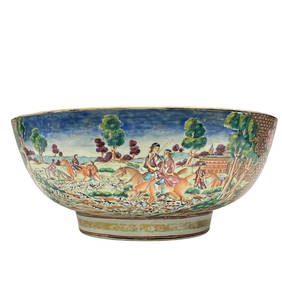
Important Qianlong Chinese Export Hunt Scene BowlPremier Auction Galleries4.4(331)See Sold PriceMar 09, 2024
A FINE CHINESE CLOISONNE ENAMEL LONGEVITY TABLE SCREENBerkeley Auction Gallery4.4(16)See Sold PriceMar 03, 2024
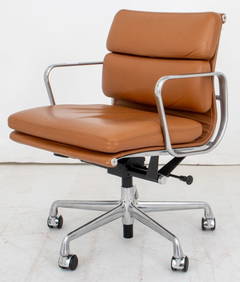
Eames for Herman Miller Executive Soft Pad ChairAuctions at Showplace4.6(740)See Sold PriceMar 03, 2024
Danish Mid-Century Modern Model CH 25 Lounge Chair in Oak and Leather by Hans J. Wegner for CarlBidhaus4.3(762)See Sold PriceFeb 26, 2024
George Nelson Herman Miller Leather "Cube" SofaAuctions at Showplace4.6(740)See Sold PriceMar 03, 2024
Hans Wegner (1914-2007), AP-19 Papa Bear chair and ottoman for A.P. Stolen, 1953-1969; DenmarkJohn Moran Auctioneers, Inc.4.7(461)See Sold PriceFeb 27, 2024
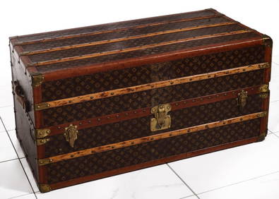
A FINE LARGE LOUIS VUITTON TRAVELING WARDROBE C. 1920sSoulis Auctions4.8(953)See Sold PriceFeb 24, 2024
Period 18Th C. Queen Anne Bonnet Top Tiger Maple HighboyRalph Fontaine Heritage Auctions Inc.4.7(236)See Sold PriceFeb 25, 2024
Rare Mid-Century Modern Egyptian Revival Ebonized "Thebes" Stool by Liberty & Company UnitedBidhaus4.3(762)See Sold PriceFeb 26, 2024
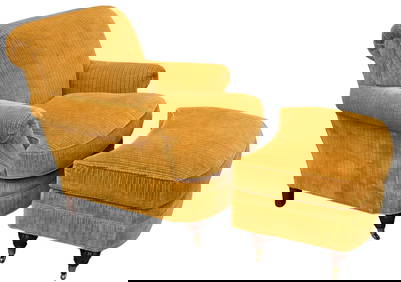
Lewis Mittman Upholstered Club Chair and OttomanNadeau's Auction Gallery4.7(409)See Sold PriceFeb 24, 2024
Single Bentwood Prague Model 811 Dining Chair by Josef Frank Josef Hoffmann for Stendig withBidhaus4.3(762)See Sold PriceFeb 24, 2024
Sold* [AMERICAN GEOGRAPHICAL SOCIETY]. A group of 6 works[AMERICAN GEOGRAPHICAL SOCIETY]. A group of 6 works published by the American Geographical Society, comprising: JOERG, W.L.G. (1885-1952), editor. Problems of Polar Research. A Series of Papers by ThiSee Sold Price
SoldGroup of Books and Map of Erie & Nia. Co.Geographical Encyclopedia of Chautaqua County 1891, 1908 Map of Erie and Niagara County by Scarborough Co., Early to Mid 19th C .Autograph Book, Plus other books -See Sold Price
SoldA Group of 11 19th and 20th century maps, comprising:A Group of 11 19th and 20th century maps, comprising: Ethnographic Map of the World. Edinburgh and London: William Blackwood & Sons, N.d.. Plate 23. 17 1/4 x 19 1/2 in. -- Geographical Division & DistSee Sold Price
SoldBarlow 1807 Group of 3 European MapsIncl Germany, Switzerland, and France. Copper Engraved Maps Published 1807 by Brightly & Kinnersley, Bungay, England for "A General View of the World, Geographical, Historical and Philosophical" by ThSee Sold Price
SoldBartholomew, John 1922 Group of 3 Large Maps of ChinaLarge Lithograph Map Published 1922 by The Times, London for "The Times Survey Atlas of the World" Maps by John George Bartholomew of the Edinburgh Geographical Institute. Centre fold as issued. PaperSee Sold Price
SoldGrp: 22 Negro Univ. Press Books and other AfricaGroup of books about the history of Africa, many published by Negro University Press. A Geographical Historie of Africa; An Essay on Colonization Particularly Applied to The Western Coast of Africa; ASee Sold Price
SoldCarey & Lea: Antique Geographical Map of Alabama, 1827Title/Content of Map: 1827 Carey & Lea Map of Alabama -- Geographical, Statistical, and Historical Map of Alabama Date Printed: 1827, Philadelphia Cartographer: Carey & Lea Size: 20.4x 16.5 in. This eSee Sold Price
Sold1826 Geographical Map of Vermont1826 hand-colored Geographical, Statistical, & Historical map of Vermont, engraved by Young & Delleker, Carey & Lea atlas page, creased, unframed, 17 3/4" x 22 1/4"See Sold Price
SoldBuchon: Antique Geographical Map of Haiti, 1825Map: Carte Geographique, Statistique et Historique de Haity Cartographer: Buchon Place & Date: Paris / 1825 Size: 21" x 16 3/4" (including text blocks). Condition: wash color; overall age toning; repaSee Sold Price
SoldGeographical Map of The WorldGeographical Map of The World with the tracks of the most Celebrated Navigators, for the elucidation of Lavoisne's Geneological, Historical, Chronological, and Geographical Atlas. By C. Gros. 1821 17See Sold Price
Buchon: Antique Geographical Map of Puerto Rico, 1825Title/Content of Map: 'Carte géographique, statistique et historique de Porto-Rico et des Iles-Vierges' The islands coloured yellow (principally Puerto Rico and Vieques) were, at the time of publicatSee Sold Price
Detailed Geographical Map of Chile, 1823Title/Content of Map: Detailed Geographical Map of Chile, 1823 Date Printed: 1823, Weimar Cartographer: Verlage des Geographrischen Instituts Size: 21 x 16" The Chile map from the scarce German versioSee Sold Price
SoldA Collection [6] of Ancient Geographical Maps of the6 ancient geographical maps of the Land of Israel in varying sizes. Etchings and prints from different publishers, 18-19th century. Writing in Latin letters. All of the maps are painted by hand from tSee Sold Price
SoldEARLY 19TH CENTURY GEOGRAPHICAL MAP OF FLORIDAc1822 Full color Florida map. It is the Geographical Statistical and Historical Map of Florida No. 37 with explanatory text surrounds the map. Drawn by Felding Lucas Jr. and engraved by Young & DellekSee Sold Price
SoldAn Enormous Colored Geographical Map of the Land ofDimensions: 53x39 cm. An enormous map of Palestine written in Italian dated on the back 1572: PALESTINAE SIVE TOTIVS TERRAE PRO MISSIONIS NOVA DESCRIPTIO AVC TORE TILEMANNO SRELLA SIGENS. Two pSee Sold Price
SoldVintage Self-Published Illustrated Map of NorthVintage Self-Published Illustrated Map of North CarolinaAn Historical and Geographical Map of the State of North Carolina, (Lousiville, Kentucky: Karl Smith, 1934), illustrated throughout with pointsSee Sold Price
Carta Corografica della Toscana e del Ducato di LuccaTitle/Content of Map: Carta Corografica della Toscana e del Ducato di Lucca Cartographer: Maggi G.Battista Date Printed: 1849 Torino Material/Medium: Paper Size: 72 x 60 cm. Geographical map on cloth,See Sold Price
SoldFive ancient geographic maps-Engravings. Europe, AsiaFive geographical maps - Europe, Asia and North Africa. *Â Carte Geographique du Monde Ancien, 1721. Asia, Europe and North Africa, 33x45 cm. *Â Carta Nuova Del Dominio, e stati del Turco Nell EurSee Sold Price
SoldCorto Viaggi - Le mappe blu dell’avventuraCorto Viaggi - Le mappe blu dell’avventura - Complete collection of the geographical maps, issued as a supplement to the magazine “CortoMaltese”. In publisher box. Une collection complète de cSee Sold Price
SoldLarge Collection of Maps of the Holy Land, Israelites'Large, unique collection of about 75 geographical maps, in color and black and white, of the Holy Land in the 16, 17 and 18th century. The maps were devotedly collected by a dedicated collector for alSee Sold Price
Sold[ATLANTE] Collezione di carte geografiche da: -[ATLANTE] Collezione di carte geografiche da: - SANTINI, Francesco e Paolo. Atlas Universel. Venice: Remondini, 1784. A collection of fine geographical maps among which the worldmap, Asia, Africa andSee Sold Price
A SET OF 48 EARLY RUSSIAN HANDCOLORED PLAYING CARDS,A SET OF 48 EARLY RUSSIAN HANDCOLORED PLAYING CARDS, PRODUCED BY THE IMPERIAL OPRHANAGE WITH GEOGRAPHICAL MAPS OF THE RUSSIAN PROVINCES, FROM THE TIME PERIOD OF ALEXANDER PUSHKIN (1827). Fabr. ImperatSee Sold Price
Nova Totius Full Color Geographical World MapThe Benefit Shop Foundation Inc.4.3(2.9k)See Sold PriceFeb 28, 2024
Vintage County Map Of NY State Plate EngravingThe Benefit Shop Foundation Inc.4.3(2.9k)See Sold PriceFeb 28, 2024
Vintage Framed Pine Island & Lacoste Island MapThe Benefit Shop Foundation Inc.4.3(2.9k)See Sold PriceMar 06, 2024
1822 MAP of CHILI GEOGRAPHICAL STATISTICAL HISTORICAL antique 17.5x 22" CHILEJasper524.5(9.9k)See Sold PriceFeb 27, 2024
VARIOUS ARTISTS [BRITISH TRAVEL GUIDES]. Group of 6 map booklets and flyers. 1930s.Swann Auction Galleries4.4(70)See Sold PriceFeb 29, 2024
Group of vintage travel maps and brochuresBaker's Antiques and Auctions3.2(471)See Sold PriceFeb 25, 2024
Group of vintage travel maps and brochuresBaker's Antiques and Auctions3.2(471)See Sold PriceFeb 25, 2024
Group of vintage travel maps and brochuresBaker's Antiques and Auctions3.2(471)See Sold PriceFeb 25, 2024
Group of vintage travel maps and brochuresBaker's Antiques and Auctions3.2(471)See Sold PriceFeb 25, 2024
Group of vintage travel maps and brochuresBaker's Antiques and Auctions3.2(471)See Sold PriceFeb 25, 2024
Group of vintage travel maps and brochuresBaker's Antiques and Auctions3.2(471)See Sold PriceFeb 25, 2024
Group of vintage travel maps and brochuresBaker's Antiques and Auctions3.2(471)See Sold PriceFeb 25, 2024
Group of vintage travel maps and brochuresBaker's Antiques and Auctions3.2(471)See Sold PriceFeb 25, 2024
Group of vintage travel maps and brochuresBaker's Antiques and Auctions3.2(471)See Sold PriceFeb 25, 2024
Group of Vintage travel maps and bookletsBaker's Antiques and Auctions3.2(471)See Sold PriceFeb 25, 2024
Geographical, Statistical, and Historical Map of the Leeward Islands.Jasper524.5(9.9k)See Sold PriceFeb 27, 2024
Geographical Statistical and Historical Map of the Windward IslandsJasper524.5(9.9k)See Sold PriceFeb 27, 2024
Geographical, Statistical, and Historical Map of the West Indies.Jasper524.5(9.9k)See Sold PriceFeb 27, 2024


![* [AMERICAN GEOGRAPHICAL SOCIETY]. A group of 6 works (1 of 1)](https://p1.liveauctioneers.com/197/136865/69466428_1_x.jpg?height=282&quality=70&version=1550699608)


![A Collection [6] of Ancient Geographical Maps of the (1 of 6)](https://p1.liveauctioneers.com/2398/92630/47375538_1_x.jpg?height=282&quality=70&version=1471793846)


![[ATLANTE] Collezione di carte geografiche da: - (1 of 1)](https://p1.liveauctioneers.com/3662/133265/67698101_1_x.jpg?height=282&quality=70&version=1545299334)


![VARIOUS ARTISTS [BRITISH TRAVEL GUIDES]. Group of 6 map booklets and flyers. 1930s. (1 of 2)](https://p1.liveauctioneers.com/199/319703/171640571_1_x.jpg?height=282&quality=70&version=1707943705)


