MATTHEWS c1856 Map Of Upper Canada Ontario Indian Land Agency Divisions Scarce!Luis Porretta Fine Arts4.3(10)See Sold PriceMar 02, 2024
DEVINE c1856 Dr Salters Map Of Lake Huron Ontario Indian Lands etc. No. 7 ScarceLuis Porretta Fine Arts4.3(10)See Sold PriceMar 02, 2024
DUNLEVIE c1856 Map Counties Of Gaspe & Bonaventure Quebec Canada SCARCE! #1Luis Porretta Fine Arts4.3(10)See Sold PriceMar 02, 2024
DUNLEVIE c1856 Map Counties Of Gaspe & Bonaventure Quebec Canada SCARCE! #2Luis Porretta Fine Arts4.3(10)See Sold PriceMar 02, 2024
Map UNITED COUNTIES LEEDS & GRENVILLE by Walling 1861 Rare Canada Map 5ft x 5ftLuis Porretta Fine Arts4.3(10)See Sold PriceMar 02, 2024
Ambroise TARDIEU c1822 Map Venice Napoleon Italian Campaign 17" x 11"Luis Porretta Fine Arts4.3(10)See Sold PriceMar 02, 2024
SoldFry and Jefferson First Edition Map of VirginiaA Map of the Inhabited Part of Virginia, containing the whole of the Province of Maryland with Part of Pennsylvania, New Jersey and North Carolina. Joshua Fry (1699-1754) and Peter Jefferson (1708-175See Sold Price
ROBERT DE VAUGONDY (FRENCH, 1688 - 1766) CARTE DE LAFrench edition of the American Fry/Jefferson map of Virginia and Maryland, published by Robert de Vaugondy, Paris, 1755. Engraved by Elizabeth Haussard. First state as shown by the appearance of the LSee Sold Price
SoldVaugondy...De La Virginie et Du Maryland c.1793.[Virginia & Maryland] Vaugondy, Robert De. Carte De La Virginie et Du Maryland. Paris, c.1793. Engraved map. 25” x 18 7/8”. French edition of the Fry-Jefferson map. Fifth state with â€�See Sold Price
Vaugondy...De La Virginie et Du Maryland c.1793.[America/ Virginia & Maryland] Vaugondy, Robert De. “Carte De La Virginie et Du Maryland.” Paris, c.1793. Engraved map. 25” x 18 7/8”. French edition of the Fry-Jefferson map.See Sold Price
SoldThomas Jefferson Notes on the State of VirginiaTitle: Notes on the State of Virginia Author: Jefferson, Thomas Description: [iv], 382 pp. Folding chart. Lacking map. (8vo) 21x13 cm. (8¼x5¼"), period calf. First English Edition.The first editionSee Sold Price
SoldJEFFERSON, THOMAS. Notes on the State of VirgiJEFFERSON, THOMAS. Notes on the State of Virginia . . . Second American Edition. Folding table; lacks the folding map. 8vo, contemporary calf, worn; the heads of the first and second text leaves clippSee Sold Price
SoldFry & Jefferson Map of VirginiaJoshua Fry (circa 1700-1754) and Peter Jefferson (1708-1757), A Map of the most inhabited part of Virginia/containing the whole province of/Maryland/with part of Pensilvania, New Jersey and North CaroSee Sold Price
SoldFry & Jefferson Map of Virginia, 1775FRY, Joshua (1699-1754) and JEFFERSON, Peter (1708-1757). A Map of the most Inhabited Part of Virginia. Engraved Map on 4 Sheets, joined. London: for Robert Sayer & Thomas Jefferys, 1751 (1775). 32 xSee Sold Price
Fry & Jefferson Map of VirginiaJoshua Fry (circa 1700-1754) and Peter Jefferson (1708-1757), A Map of the most inhabited part of Virginia/containing the whole province of/Maryland/with part of Pensilvania, New Jersey and North CaroSee Sold Price
SoldFry & Jefferson Map of VirginiaJoshua Fry (circa 1700-1754) and Peter Jefferson (1708-1757), [A Map of the most inhabited part of Virginia / containing the whole province of / Maryland / with part of Pensilvania, New Jersey and NorSee Sold Price
SoldFry & Jefferson Map of Virginia, 1775FRY, Joshua (1699-1754), and JEFFERSON, Peter (1708-1757). A map of the most inhabited part of Virginia containing the whole province of Maryland with part of Pensilvania, New Jersey and North CarolinSee Sold Price
Fry & Jefferson Map of Virginia 1775FRY, Joshua (1699-1754) and JEFFERSON, Peter (1708-1757). A Map of the most Inhabited Part of Virginia. Engraved Map on 4 Sheets, joined.London: for Robert Sayer & Thomas Jefferys, 1751 (1775). 32 x 5See Sold Price
SoldFry & Jefferson Map of Virginia, Bottom Half OnlyFRY, Joshua (1699-1754), and JEFFERSON, Peter (1708-1757). A map of the most inhabited part of Virginia containing the whole province of Maryland with part of Pensilvania, New Jersey and North CarolinSee Sold Price
Fry & Jefferson 1775 Map of VirginiaA Map of the most Inhabited Part of Virginia. Joshua Fry (1699-1754) and Peter Jefferson (1708-1757). Engraved Map on 4 Sheets, joined. London: for Robert Sayer & Thomas Jefferys, 1775. 32 x 50 inchesSee Sold Price
SoldFry and Jefferson Engraved Map of VirginiaA map of the most inhabited part of Virginia containing the whole province of Maryland with part of Pensilvania, New Jersey and North Carolina. Joshua Fry (c.1700-1754) & Peter Jefferson (1708-1757).See Sold Price
Martha's Vineyard Map Massachusetts Tisbury EdgarMartha's Vineyard / Dukes County, Massachusetts.'' Published by B. Ashburton Tripp: Alexandria, Virginia. First edition. Map features the Island of Martha's Vineyard in center; details include towns,See Sold Price
Martha's Vineyard Map Massachusetts Tisbury Edgartown''Martha's Vineyard / Dukes County, Massachusetts.'' Published by B. Ashburton Tripp: Alexandria, Virginia. First edition. Map features the Island of Martha's Vineyard in center; details include townsSee Sold Price
SoldFry & Jefferson. Maryland and Virginia mapdated 1755; "Carte de la Virginie et de Maryland," (sic) by Robert de Vaugondy based on a map by Joshua Fry and Peter Jefferson, 21 x 26 in., in ebonized giltwood eglomise frameSee Sold Price
SoldWoolf (Virginia) Roger FryWoolf (Virginia) Roger Fry, first edition, slight browning, a few light stains to titles and frontispiece, original cloth, partly faded, dust-jacket, very slightly soiled, lightly stained, extSee Sold Price
SoldThomas Jefferson: First Edition of Notes on the State of Virginia (Edmund Randolph's Copy,Rare book authored by Thomas Jefferson, owned and signed by fellow Virginian founding father Edmund Randolph: Notes on the State of Virginia: written in the year 1781, somewhat corrected and enlargedSee Sold Price
SoldGeorge B McClellan REPORT ON THE ORGANIZATION ANDGeorge B McClellan REPORT ON THE ORGANIZATION AND CAMPAIGNS OF THE ARMY OF THE POTOMAC 1864 First Edition Fold‾Out Map Battle of Antietam Western Virginia Battle‾Field Plans United StatesSee Sold Price
SoldVictorian Photographs - Bloomsbury GroupCameron (Julia Margaret) Victorian Photographs of Famous Men & Fair Women,introductions by Virginia Woolf and Roger Fry, first edition, number 94 of 450 copies, 25 photographic plates with capSee Sold Price
Sold3 Books incl: THE FRY & JEFFERSON MAP..., 1966.[Virginia Geography] 3 Titles. ++ John Smith. THE GENERALL HISTORIE OF VIRGINIA, NEW-ENGLAND AND THE SUMMER ISLES… (Cleveland: World Publishing, “66-“ LCCN). 4to. Minor stain to clamshell case,See Sold Price
SoldKitchin - Virginia from the Best AuthoritiesThomas Kitchin (1719-1784), A New Map of Virginia from the Best Authorities, 1761 from the London Magazine after the Fry-Jefferson map of 1753, black and white line engraving, 7-3/8 x 9-1/4 in. (platSee Sold Price
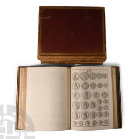
Numismatic Books - Rudding's Coinage of Britain Vol I-III, Plus SuplementTimeLine Auctions Ltd.4.6(183)See Sold PriceMar 09, 2024
1888 Hand Book of the Pennsylvania Lines Containing Maps of Principal Cities - First EditionRail & Road Auctions4.6(165)See Sold PriceMar 07, 2024
A 1971 Walt Disney World Magic Kingdom Souvenir Map.Van Eaton Galleries4.6(99)See Sold PriceMar 02, 2024
JEFFERSON AND HIS TIMES BY DUMAS MALONE, 3 VOLUMES SIGNED, 2 FIRST EDITIONS – 6 VOLUMES PLUS ONEThe Rug Life4.3(13)See Sold PriceMar 07, 2024
D'Entrecasteaux - Tasmania, Australia: Map of the Northern Portion of Recherche Bay. 5Trillium Antique Prints & Rare Books4.5(32)See Sold PriceFeb 24, 2024
D'Entrecasteaux - Map of Australia (New Holland), New Zealand, and southern Asia and surroundingTrillium Antique Prints & Rare Books4.5(32)See Sold PriceFeb 24, 2024
De Jode, Rare, pub. 1593 - Map of Luxembourg (Lutzenburgii montuosissimi ac saltuosissimi ducatusTrillium Antique Prints & Rare Books4.5(32)See Sold PriceFeb 24, 2024
De Jode, Rare, pub. 1593 - Map of the British Isles [England, Scotland, Ireland] (Angliae Scotiae etTrillium Antique Prints & Rare Books4.5(32)See Sold PriceFeb 24, 2024
De Jode, Rare, pub. 1593 - Map of the Czech Republic or Kingdom of Bohemia (Chorographia insignisTrillium Antique Prints & Rare Books4.5(32)See Sold PriceFeb 24, 2024
De Jode, Rare, pub. 1593 - Map of the Middle East, Eastern Asia (Primae Partis Asiae accurataTrillium Antique Prints & Rare Books4.5(32)See Sold PriceFeb 24, 2024
1855 NOTES ON CENTRAL AMERICA by E. G. Squier antique w/ MAPSJasper524.5(9.9k)See Sold PriceFeb 27, 2024
Ireland.- Smedley (Edward) Erin. A Georgraphical and Descriptive Poem, 2 parts in 1, first edition,Forum Auctions4.3(53)See Sold PriceFeb 29, 2024
First World War.- Petre (F.Loraine), Wilfrid Ewart & Major General Lowther. The Scots Guards in theForum Auctions4.3(53)See Sold PriceFeb 29, 2024
Medicine.- Kennedy (James) The History of the Contagious Cholera, first edition, 1831 & others (11)Forum Auctions4.3(53)See Sold PriceFeb 29, 2024
West Indies. Rand, McNally & Co.'S Indexed Atlas Map of the West Indies.Jasper524.5(9.9k)See Sold PriceFeb 27, 2024
1792 OLD INDIA HISTORY ANTIQUE ILLUSTRATED WITH MAPS OF THE EIGHTEENTH CENTURY IN FRENCHNY Elizabeth 4.2(86)See Sold PriceMar 03, 2024
Nancy Drew #19 "The Quest Of The Missing Map" 1942 Dust Jacket First EditionRapid Estate Liquidators and Auction Gallery4.5(1.1k)See Sold PriceFeb 27, 2024


![De Jode, Rare, pub. 1593 - Map of the British Isles [England, Scotland, Ireland] (Angliae Scotiae et (1 of 2)](https://p1.liveauctioneers.com/6581/319571/171593327_1_x.jpg?height=282&quality=70&version=1707853304)


