2012 Famous Fabrics President John F. Kennedy & Marilyn Monroe Signed Cut 1/1Mynt Auctions4.6(680)See Sold PriceFeb 26, 2024
1952 JOHN F. KENNEDY LETTER to MS. HELEN KEYESJohn McInnis Auctioneers,LLC4.6(502)See Sold PriceFeb 25, 2024
Group of FDR and Truman Political Campaign and Satire ButtonsDana J. Tharp Auctions4.7(268)See Sold PriceFeb 24, 2024
Large Collection of Antique Buttons DisplayPremier Auction Galleries4.3(329)See Sold PriceMar 09, 2024
"THE PRESIDENTS OF THE UNITED STATES" N. CURRIERJohn McInnis Auctioneers,LLC4.6(502)See Sold PriceFeb 25, 2024
THE JOHN F. KENNEDY MEMORIAL at RUNNYMEDEJohn McInnis Auctioneers,LLC4.6(502)See Sold PriceFeb 25, 2024
JOHN F. KENNEDY, Jr. & AUCHINCLOSS GRANDCHILDRENJohn McInnis Auctioneers,LLC4.6(502)See Sold PriceFeb 25, 2024
1930's / 40's Chicago Political Campaign Umbrella.Direct Auction Galleries 4.7(322)See Sold PriceFeb 24, 2024
Union Pacific RR Across The Continent West From Omaha, NE Book-April 2, 1868JM Hobby Supply and Railroad Artifact Auctions4.4(126)See Sold PriceFeb 24, 2024
JOHN F. KENNEDY, Jr. with COUSIN CECIL in 1964John McInnis Auctioneers,LLC4.6(502)See Sold PriceFeb 25, 2024
Large Group of John F. Kennedy Campaign Ephemera With Rare Sealed PacketsDana J. Tharp Auctions4.7(268)See Sold PriceFeb 24, 2024
SOLON FRANCIS MONTECELLO BADGER (Massachusetts, 1873-1919), Portrait of the four-masted schoonerEldred's4.7(409)See Sold PriceFeb 28, 2024
2009 Medalcraft Inauguration of President Barack Obama 3 Medal Set; 14k, Bronze and .999 Silver inDana J. Tharp Auctions4.7(268)See Sold PriceFeb 24, 2024
Fry & Jefferson 1775 Map of VirginiaA Map of the most Inhabited Part of Virginia. Joshua Fry (1699-1754) and Peter Jefferson (1708-1757). Engraved Map on 4 Sheets, joined. London: for Robert Sayer & Thomas Jefferys, 1775. 32 x 50 inchesSee Sold Price
SoldFry & Jefferson Map of Virginia, 1775FRY, Joshua (1699-1754) and JEFFERSON, Peter (1708-1757). A Map of the most Inhabited Part of Virginia. Engraved Map on 4 Sheets, joined. London: for Robert Sayer & Thomas Jefferys, 1751 (1775). 32 xSee Sold Price
SoldFry & Jefferson Map of Virginia, 1775FRY, Joshua (1699-1754), and JEFFERSON, Peter (1708-1757). A map of the most inhabited part of Virginia containing the whole province of Maryland with part of Pensilvania, New Jersey and North CarolinSee Sold Price
Fry & Jefferson Map of Virginia 1775FRY, Joshua (1699-1754) and JEFFERSON, Peter (1708-1757). A Map of the most Inhabited Part of Virginia. Engraved Map on 4 Sheets, joined.London: for Robert Sayer & Thomas Jefferys, 1751 (1775). 32 x 5See Sold Price
SoldFry/Jefferson map of Virginia & Maryland ...dated 1775; " A Map of the most Inhabited part of Virginia containing the whole Province of Maryland with part of Pennsylvania, New Jersey and North Carolina Drawn by Joshua Fry & Peter Jefferson in 1See Sold Price
SoldWonderful Engraved Maps from Jefferys' American AtlasA Map of the most Inhabited Part of Virginia containing the whole Province of Maryland...Drawn by Joshua Fry & Peter Jefferson in 1775. Thomas Jefferys (c. 1719 – 1771). Engraved map with original hSee Sold Price
SoldJefferson and Fry Map of Virgina, 1776A Map of the Most Inhabited part of Virginia... Joshua Fry (1699-1754) & Peter Jefferson (1708-1757). Engraved map in four sheets. London: R. Sayer & J. Bennett, 1775. 16 3/4 x 24 1/2 inches sheet, 41See Sold Price
SoldFry & Jefferson Map of VirginiaJoshua Fry (circa 1700-1754) and Peter Jefferson (1708-1757), A Map of the most inhabited part of Virginia/containing the whole province of/Maryland/with part of Pensilvania, New Jersey and North CaroSee Sold Price
Fry & Jefferson Map of VirginiaJoshua Fry (circa 1700-1754) and Peter Jefferson (1708-1757), A Map of the most inhabited part of Virginia/containing the whole province of/Maryland/with part of Pensilvania, New Jersey and North CaroSee Sold Price
SoldFry & Jefferson Map of VirginiaJoshua Fry (circa 1700-1754) and Peter Jefferson (1708-1757), [A Map of the most inhabited part of Virginia / containing the whole province of / Maryland / with part of Pensilvania, New Jersey and NorSee Sold Price
SoldFry & Jefferson Map of Virginia, Bottom Half OnlyFRY, Joshua (1699-1754), and JEFFERSON, Peter (1708-1757). A map of the most inhabited part of Virginia containing the whole province of Maryland with part of Pensilvania, New Jersey and North CarolinSee Sold Price
ROBERT DE VAUGONDY (FRENCH, 1688 - 1766) CARTE DE LAFrench edition of the American Fry/Jefferson map of Virginia and Maryland, published by Robert de Vaugondy, Paris, 1755. Engraved by Elizabeth Haussard. First state as shown by the appearance of the LSee Sold Price
SoldFry and Jefferson Engraved Map of VirginiaA map of the most inhabited part of Virginia containing the whole province of Maryland with part of Pensilvania, New Jersey and North Carolina. Joshua Fry (c.1700-1754) & Peter Jefferson (1708-1757).See Sold Price
SoldFry & Jefferson. Maryland and Virginia mapdated 1755; "Carte de la Virginie et de Maryland," (sic) by Robert de Vaugondy based on a map by Joshua Fry and Peter Jefferson, 21 x 26 in., in ebonized giltwood eglomise frameSee Sold Price
SoldFry and Jefferson First Edition Map of VirginiaA Map of the Inhabited Part of Virginia, containing the whole of the Province of Maryland with Part of Pennsylvania, New Jersey and North Carolina. Joshua Fry (1699-1754) and Peter Jefferson (1708-175See Sold Price
Sold3 Books incl: THE FRY & JEFFERSON MAP..., 1966.[Virginia Geography] 3 Titles. ++ John Smith. THE GENERALL HISTORIE OF VIRGINIA, NEW-ENGLAND AND THE SUMMER ISLES… (Cleveland: World Publishing, “66-“ LCCN). 4to. Minor stain to clamshell case,See Sold Price
SoldKitchin - Virginia from the Best AuthoritiesThomas Kitchin (1719-1784), A New Map of Virginia from the Best Authorities, 1761 from the London Magazine after the Fry-Jefferson map of 1753, black and white line engraving, 7-3/8 x 9-1/4 in. (platSee Sold Price
SoldVaugondy...De La Virginie et Du Maryland c.1793.[Virginia & Maryland] Vaugondy, Robert De. Carte De La Virginie et Du Maryland. Paris, c.1793. Engraved map. 25” x 18 7/8”. French edition of the Fry-Jefferson map. Fifth state with â€�See Sold Price
Vaugondy...De La Virginie et Du Maryland c.1793.[America/ Virginia & Maryland] Vaugondy, Robert De. “Carte De La Virginie et Du Maryland.” Paris, c.1793. Engraved map. 25” x 18 7/8”. French edition of the Fry-Jefferson map.See Sold Price
SoldReproduction of the Fry JeffersonMap of Virginia, 1751 A Map of the Most Inhabited part of Virginia by Joshua Fry and Peter Jefferson, 1751, 30-1/2 x 48-1/2 (sight); framed fine condition. Notes: Brunk Auctions provides condition repSee Sold Price
Fry and Jefferson, A Map of the most Inhabited part ofFRY, Joshua (1699-1754) and Peter JEFFERSON (1708-1757). A Map of the most Inhabited part of Virginia containing the whole province of Maryland with Part of Pensilvania, New Jersey and North Carolina.See Sold Price
SoldJoshua Fry and Peter Jefferson, "A Map ofJoshua Fry and Peter Jefferson, "A Map of the most Inhabited part of Virginia containing the whole Province of Maryland with part of Pennsylvania, New Jersey and North Carolina, Drawn by Joshua Fry &See Sold Price
Sold18th c. de Vaugondy Map of Virginia and MarylandDouble-page hand-colored engraved folio, titled "Carte de la Virginie et du Maryland", Robert de Vaugondy, Paris, circa 1755. Based on a map by Joshua Fry and Peter Jefferson, sight size: 21 1/8 x 31See Sold Price
SoldDe Vaugondy. 18th c. map of Virginia and MarylandDouble-page hand-colored engraved folio, titled "Carte de la Virginie et du Maryland", Robert de Vaugondy, Paris, circa 1755. Based on a map by Joshua Fry and Peter Jefferson, plate size: 19 1/4 x 25See Sold Price
Group of 15 Printed or Lithographed Items, including: litho...Potter & Potter Auctions4.6(539)See Sold PriceMar 07, 2024
[ENSLAVEMENT & ABOLITION]. 100 Dollars Reward! Ran Away from the service of Mr. George Ridenour, inFreeman's | Hindman4.4(1.6k)See Sold PriceFeb 27, 2024
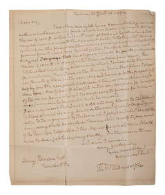
RANDOLPH, Thomas Mann (1768-1828), Virginia Governor and Thomas Jefferson's son-in-law. AutographFreeman's | Hindman4.4(1.6k)See Sold PriceFeb 27, 2024
Elias Fries (1794 - 1878) - Set of 4 Mushroom Prints - Cantarellus Aurantiacus - Merulius LacrymansProverde Auctions4.3(3)See Sold PriceFeb 28, 2024
Elias Fries (1794 - 1878) - Set of 4 Mushroom Prints - Agaricus Rubescens - Polyporus FomentariusProverde Auctions4.3(3)See Sold PriceFeb 28, 2024
Map of Yorktown - York County in Virginia - United StatesProverde Auctions4.3(3)See Sold PriceFeb 28, 2024
Mary Jane Thomas Stokes - Map of Lighthouses of the Chesapeake Bay. Past and PresentProverde Auctions4.3(3)See Sold PriceFeb 28, 2024
Virginia and West Virginia Topography MapsRapid Estate Liquidators and Auction Gallery4.5(1.1k)See Sold PriceFeb 28, 2024
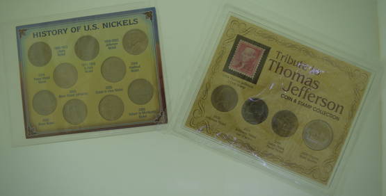
History of US Nickels and Tribute to Thomas Jefferson Coin and Stamp CollectionKamy INC4.3(81)See Sold PriceMar 15, 2024
2000 20 piece United States Mint Set with Sacagawea DollarKey Date Coins4.2(1.2k)See Sold PriceFeb 23, 2024
2000 20 piece United States Mint Set with Sacagawea DollarKey Date Coins4.2(1.2k)See Sold PriceFeb 29, 2024


![[ENSLAVEMENT & ABOLITION]. 100 Dollars Reward! Ran Away from the service of Mr. George Ridenour, in (1 of 1)](https://p1.liveauctioneers.com/197/319238/171468020_1_x.jpg?height=282&quality=70&version=1707520367)