Napoleon's ? Tomb Building Dome With Casket Model Copper & Bevel Glass Very KQQLRbfinearts4.4(571)See Sold PriceFeb 24, 2024
SoldFrench Map of Island of California & History, 1700Nicolas De Fer (French, 1646 to 1720) / Charles Inselin (French, 1673 to 1715), printed in the 19th century CE, first created in 1700 CE. A fun pair of black prints on laid paper; a map of the "IslandSee Sold Price
SoldMap: Americas Showing The Island Of CaliforniaHistoric MapsMap Of The Americas Showing The Island Of California c. 1700, Map of the Americas, Titled "Americae Tam Septentrionalis Quam Meridionalis," by A. F. Zurner, published by P. SchenkSee Sold Price
SoldMap: Americas Showing The Island Of CaliforniaMapsMap Of The Americas Showing The Island Of California c.1700, Map of the Americas, Titled “Americae Tam Septentrionalis Quam Meridionalis,” by A. F. Zurner, published by P. Schenk in AmSee Sold Price
SoldMap: Americas Showing The Island Of CaliforniaHistoric MapsMap Of The Americas Showing The Island Of California c. 1700, Map of the Americas, Titled Americae Tam Septentrionalis Quam Meridionalis," by A. F. Zurner, published by P. Schenk in AmsteSee Sold Price
c1700 Western America Map California as an IslandHistoric Maps Petrini Paolo's "L'America Dedicata all'Illustriss..." Map of Western American with California as an Island & Vignettes c. 1700, Hand-Colored Copper Plate Engraved Map, Upper Left PortioSee Sold Price
c1700 Western America Map California as an IslandHistoric Maps Hand-Colored Copper Plate Engraved Map of Western American with California as an Island Wonderful Vignettes c. 1700, Hand-Colored Copper Plate Engraved Map, Upper Left Portion of PetriniSee Sold Price
c1700 Western America Map California as an IslandHistoric Maps Western American with California as an Island & Vignettes c. 1700, Hand-Colored Copper Plate Engraved Map, Upper Left Portion of Petrini Paolo's L'America Dedicata all'Illustriss. ed EccSee Sold Price
SoldSmall 1735 French map with California as an Island andTitle: Amerique Septentrionale par N. Sanson d'Abbeville Geographe du Roy Map maker: Nicolas Sanson, Introduction a l'histoire de l'Asie, de l'Afrique et de l'Amerique... par Mr. Bruzen la MartiniereSee Sold Price
Sanson: Antique Map of North America, 1735Title: Amerique Septentrionale par N. Sanson d'Abbeville Geographe du Roy, Small 1735 French map with California as an Island and misshapen Great Lakes Map maker: Nicolas Sanson, Introduction a l'histSee Sold Price
Sanson: Antique Map of North America, 1735Title: Amerique Septentrionale par N. Sanson d'Abbeville Geographe du Roy. Small 1735 French map with California as an Island and misshapen Great Lakes Map maker: Nicolas Sanson, Introduction a l'histSee Sold Price
Americas w/ California Island 1719 Mallet Hand ColAmericas w/ California Island 1719 Mallet Hand Colored Map - Awesome French Map. - OP172ED - c. 1719 with California as an island. Hand Colored. Amazing detail and color. 6 1/2 x8". - Thank you for viSee Sold Price
Americas w/ California Island 1719 Mallet Hand ColAmericas w/ California Island 1719 Mallet Hand Colored Map - Awesome French Map. - OP172ED - c. 1719 with California as an island. Hand Colored. Amazing detail and color. 6 1/2 x8". - Thank you for viSee Sold Price
SoldAmericas w/ California Island 1719 Mallet Hand ColAmericas w/ California Island 1719 Mallet Hand Colored Map - Awesome French Map. - OP172ED - c. 1719 with California as an island. Hand Colored. Amazing detail and color. 6 1/2 x8". - Thank you for viSee Sold Price
SoldAmericas w/ California Island 1719 Mallet Hand ColAmericas w/ California Island 1719 Mallet Hand Colored Map - Awesome French Map. - OP172ED - c. 1719 with California as an island. Hand Colored. Amazing detail and color. 6 1/2 x8". - Thank you for viSee Sold Price
SoldAmericas w/ California Island 1719 Mallet Hand ColAmericas w/ California Island 1719 Mallet Hand Colored Map - Awesome French Map. - OP172ED - c. 1719 with California as an island. Hand Colored. Amazing detail and color. 6 1/2 x8". - Thank you for viSee Sold Price
Sold8 vols. (3 wrappers) Cartography - American Regio8 vols. (3 wrappers) Cartography - American Regional Subjects: Polk, Dora Beale. The Island of California: A History of the Myth. Spokane, 1991. 8vo, orig. cloth, d/j. Illus., maps. * McLaughlin, GlenSee Sold Price
SoldMiniature world map with California an islandHeading: Author: Jansson, Jan Title: Typus Orbis Terrarum Place Published: Amsterdam Publisher: Date Published: 1628-[1630?] Description: Copper-engraved double-hemisphereSee Sold Price
Miniature world map with California an islandHeading: Author: Jansson, Jan Title: Typus Orbis Terrarum Place Published: Amsterdam Publisher: Date Published: 1628-[1630?] Description: Copper-engraved double-hemisphereSee Sold Price
SoldNorth and South America with California an island 1700Heading: Author: De Fer, Nicolas Title: L'Amerique, Meridionale et Septentrionale Dressee selon les Dernieres Relations et Suivant les Nouvelles Decouvertes... Place Published: Paris Publisher:See Sold Price
SoldWorld map with California an islandHeading: (World) Author: Anonymous Title: Mappamondo Place Published: [No place] Publisher: Date Published: [c.1700?] Description: Copper-engraved double-hemisphere map of tSee Sold Price
SoldWorld map with California an islandHeading: Author: La Feuille, Daniel de Title: Mappe-Monde, Planisphere ou Carte Generale du Monde Place Published: Amsterdam? Publisher: Date Published: c.1700 Description:See Sold Price
SoldWestern Hemisphere Map with California as IslandHistoric MapsWestern Hemisphere Map with California as an Island c. 1720, Hand-colored Map entitled, "DU GLOBE TERRESTRE," Western Hemisphere with California as an Island, Choice Near Mint. ThSee Sold Price
SoldMap of California as Island and back again c.1770Title: Carte de la Californie suivant I. La carte manuscrite de l'Amérique de Mathieu Néron Pecci olen dresse à Florence en 1604 / II. Sanson 1656 / III. De L'Isle Amérique Sept. 1700 / IV. le PerSee Sold Price
SoldMap of California as Island and back again c.1770Title: Carte de la Californie suivant I. La carte manuscrite de l'Amérique de Mathieu Néron Pecci olen dresse à Florence en 1604 / II. Sanson 1656 / III. De L'Isle Amérique Sept. 1700 / IV. le PerSee Sold Price
LATE 17TH C. FRENCH MAP OF THE NEW WORLD BY ALEXIS-HUBERT JAILLOT (1632-1712)Thomaston Place Auction Galleries4.4(386)See Sold PriceFeb 24, 2024
EARLY 18TH C. DUTCH CHART OF PACIFIC OCEAN BY FREDERIK DE WIT (1629-1706) WITH CALIFORNIA AS ANThomaston Place Auction Galleries4.4(386)See Sold PriceFeb 24, 2024
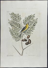
Catesby, Folio - Tumble-Turds (Dung Beetle) with Canada Lily. Sup-11Trillium Antique Prints & Rare Books4.5(30)See Sold PriceFeb 24, 2024
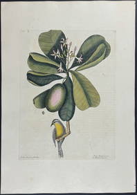
Catesby, Folio - American Goldfinch with Acacia. 1-43Trillium Antique Prints & Rare Books4.5(30)See Sold PriceFeb 24, 2024
Catesby, Folio - Bahama Titmouse with Seven Years Apple. 1-59Trillium Antique Prints & Rare Books4.5(30)See Sold PriceFeb 24, 2024
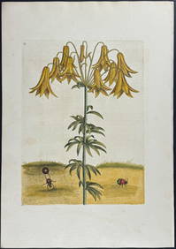
Catesby, Folio - American Partridge with Attamusco Lily. Sup-12Trillium Antique Prints & Rare Books4.5(30)See Sold PriceFeb 24, 2024
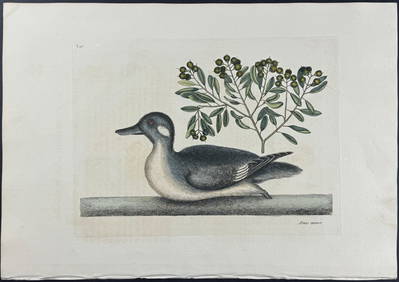
Catesby, Folio - Little Brown Duck with Soap-Wood. 1-98Trillium Antique Prints & Rare Books4.5(30)See Sold PriceFeb 24, 2024
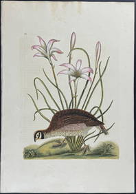
Catesby, Folio - Red Bellied Woodpecker & Hairy Woodpecker with Black Oak. 1-19Trillium Antique Prints & Rare Books4.5(30)See Sold PriceFeb 24, 2024
1749-1771 HISTORY OF ROMAN EMPERORS 12 VOLUMES antique ILLUSTRATED w/ MAPSJasper524.5(9.8k)See Sold PriceFeb 27, 2024
Italian edition of Sanson's map of North America, 1677PBA Galleries4.7(381)See Sold PriceMar 07, 2024