SoldFrench & Indian War Period Map - Port of BostonHistoric Maps French & Indian War Period Map of the Port of Boston 1763 Map of the Port of Boston, "Carta Rappresentante il Porto di Boston," Engraved by G. M. Terreni, Choice Crisp Near Mint. This hiSee Sold Price
Soldc. 1763 Proof Impression Map, the Port of BostonHistoric Maps Engraved Proof Impression Map of the Port of Boston c. 1763 French & Indian War Era, Copperplate Hand-Engraved Printed Map Titled, “Carta Rappresentante il Porta di Boston,” by G.M.See Sold Price
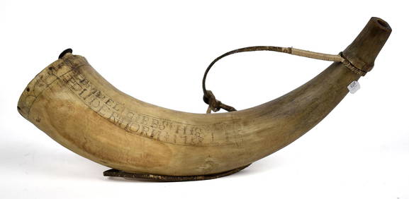
SoldLarge Quebec French & Indian War Period Map Powder HornA large view of Quebec City is engraved on this well crafted horn. The carving of the stone fort located there, includes a large and well executed British flag flying over the fort. Additional imagesSee Sold Price
Guadaloupe, London Magazine 1759Title: Guadaloupe, one of the Caribbee Islands Subject: Guadaloupe Maker: London Magazine Date: 1759, London Magazine: London Size: 7.25 x 8.75 inches French & Indian War-period map of the island thatSee Sold Price
SoldHistoric 1755 Map of British & French Settlements inHistoric Maps 1755 French & Indian War Period Map with British & French Settlements in North America Displaying 30 Forts! 1755 French and Indian War Period, Map of North America titled, “A Map of thSee Sold Price
Map of America Principal Seat of War 1756FRENCH AND INDIAN WAR PERIOD: MAP OF THAT PART OF AMERICA WHICH WAS THE PRINCIPAL SEAT OF WAR IN 1756.” Engraving of the Northeastern Colonies and Canada from Lake Ontario to Nova Scotia, centeringSee Sold Price
SoldThree 18th C. U.S. Maps, inc. SouthernThree (3) French and Indian War period maps. 1st item: John Gibson: THE BRITISH GOVERNMENT IN NORTH AMERICA, Laid Down Agreeable To The Proclamation of Oct. 7, 1763. Published in The Gentleman's MagazSee Sold Price
Sold1758 MAP of NORTH AMERICA by T. Jefferys, LondonHistoric Maps 1758 Map of “NORTH AMERICA” by T. Jefferys, London 1758 French & Indian War Period, Historic Engraved MAP titled, “NORTH AMERICA,” with Vignette depiction of Native American IndiSee Sold Price
1758 MAP of NORTH AMERICA by T. Jefferys, LondonHistoric Maps 1758 Map of "NORTH AMERICA" by T. Jefferys, London 1758 French & Indian War Period, Historic Engraved MAP titled, "NORTH AMERICA," with Vignette depiction of Native American Indians, bySee Sold Price
Sold1758 MAP of NORTH AMERICA by T. Jefferys, LondonHistoric Maps 1758 Map of “NORTH AMERICA” by T. Jefferys, London 1758 French & Indian War Period, Historic Engraved MAP titled, “NORTH AMERICA,” with Vignette depiction of Native American IndiSee Sold Price
Sold1758 MAP of NORTH AMERICA by T. Jefferys, LondonHistoric Maps 1758 Map of "NORTH AMERICA" by T. Jefferys, London 1758 French & Indian War Period, Historic Engraved MAP titled, "NORTH AMERICA," with Vignette depiction of Native American Indians, bySee Sold Price
Sold1758 MAP of NORTH AMERICA by T. Jefferys, LondonHistoric Maps 1758 Map of "NORTH AMERICA" by T. Jefferys, London 1758 French & Indian War Period, Historic Engraved MAP titled, "NORTH AMERICA," with Vignette depiction of Native American Indians, bySee Sold Price
SoldLOT OF 7: CONTEMPORARY ENGRAVED POWDER HORNS.Comprising seven contemporary engraved horns, including a copy of John Bush's powder horn dated 1756. One is a copy of a professionally engraved French and Indian War period New York map horn with BriSee Sold Price
Sold1757 Map of New England, New York + PA by BellinHistoric Maps 1757 Map of New England, New York, and Pennsylvania 1757 French & Indian War Period, Hand-Colored Copper-Plate Engraved Map titled, “Carte de la Nouvelle Angleterre, Nouvelle Yorck, etSee Sold Price
SoldHudson Valley Map Horn Commemorating John OgdenDESCRIPTION: Reproduction Scottish type Hudson Valley map horn commemorating the French/Indian war period and John Ogden (1740-1810). During the Revolutionary War, John Ogden served as a private in CaSee Sold Price
Soldc. 1756 Colonial Boston WOODBLOCK Printing PlateColonial America "Full Eclipse" Colonial Illustration Woodblock Printing Plate by John Draper, Boston Weekly-Newsletter Publisher c. 1756 Colonial French and Indian War Period, Hand-Engraved WoodblockSee Sold Price
SoldEngraved Fort Edward Map Powder Horn of James Lekey,This French and Indian War period horn is inscribed: "the 3 Day 1757" "FORT EDWARD APRIL"See Sold Price
Ames 1761 - An Astronomical Diary, Boston: Printed 1760Colonial America Ames 1761 "An Astronomical Diary" Boston: Printed 1760 Ames 1761. French and Indian War Period, "An Astronomical Diary, or an Almanack for the Year of our Lord Christ, 1761." completeSee Sold Price
SoldAmes 1761 - An Astronomical Diary, Boston: Printed 1760Colonial America Ames 1761 “An Astronomical Diary” Boston: Printed 1760 Ames 1761. French and Indian War Period, “An Astronomical Diary, or an Almanack for the Year of our Lord Christ, 1761.”See Sold Price
SoldAmes 1761 - An Astronomical Diary, Boston: 1760Colonial America Ames 1761 "An Astronomical Diary" Boston: Printed 1760 Ames 1761. French and Indian War Period, "An Astronomical Diary, or an Almanack for the Year of our Lord Christ, 1761.", CompletSee Sold Price
Important colonial period French and Indian war era map centering on the Mississippi River by BellinTitle: Important colonial period French and Indian war era map centering on the Mississippi River by Bellin Date/Period: c1744 Materials: Copper plate engraved Size: 12 x 8 1/2” Important coloniSee Sold Price
RARE and important map of Montreal from the French andTitle: RARE and important map of Montreal from the French and Indian war. 1759. By Thomas Jefferys, London Date/Period: 1759 Materials: Copperplate engraved. Size: 15 x 10 1/2”. Published in 1759 bySee Sold Price
RARE and important map of Montreal from the French andTitle: RARE and important map of Montreal from the French and Indian war. 1759. By Thomas Jefferys, London Date/Period: 1759 Materials: Copperplate engraved. Size: 15 x 10 1/2”. Published in 1759 bySee Sold Price
SoldThe Army and Navy of America 1853The Army and Navy of America from the period of the French and Indian Wars to the close of the Mexican War: Independent account of warlike operations on land and sea. 1853. 684 pp. with illustrations,See Sold Price
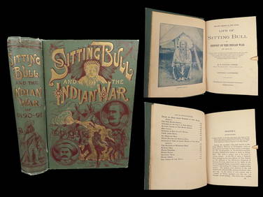
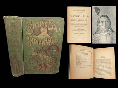
1891 Sitting Bull 1st ed Life Native American Sioux Indians DAKOTA Ghost DanceSchilb Antiquarian Rare Books4.8(422)See Sold PriceMar 10, 2024
18TH C. ANTIQUE MAP: FRENCH & INDIAN WAR, FRAMEDThomaston Place Auction Galleries4.4(389)See Sold PriceFeb 24, 2024
1818 RARE Geography Made Easy MAPS Jedidiah Morse Boston Indians Atlas AsiaSchilb Antiquarian Rare Books4.8(422)See Sold PriceMar 31, 2024
1891 DAKOTA Indians 1st ed Life Sitting Bull Native American Sioux Ghost DanceSchilb Antiquarian Rare Books4.8(422)See Sold PriceMar 31, 2024
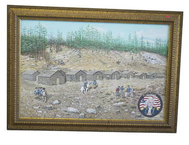
VINTAGE PAINTING ISRAEL PUTNAM REDDING CONNECTICUTCharleston Estate Services Ltd.4.5(64)See Sold PriceMar 03, 2024
[CIVIL WAR]. Printed plea for recognition from a Black camp follower from Louisiana, who served withFreeman's | Hindman4.4(1.6k)See Sold PriceFeb 27, 2024
1704 DESCRIPTION OF ALL THE SEATS OF THE PRESENT WARS OF EUROPE antique w/ MAPSJasper524.5(9.8k)See Sold PriceFeb 27, 2024
MAURICE UTRILLO - Painting - (1883 - 1955) - IN THE STYLE OFABC Gallery4.2(8)See Sold PriceMar 18, 2024
Hist. of Indian wars of the Far West - Massacres of the MountainsJasper524.5(9.8k)See Sold PriceFeb 27, 2024
T. Kelly - Plan of Bruseels - Battle of Waterloo, London - History of the French RevolutionProverde Auctions4.3(3)See Sold PriceFeb 28, 2024


![[CIVIL WAR]. Printed plea for recognition from a Black camp follower from Louisiana, who served with (1 of 2)](https://p1.liveauctioneers.com/197/319238/171468117_1_x.jpg?height=282&quality=70&version=1707520367)