SoldFRENCH 18TH CENTURY MAP OF RIO DE JANEIROFRENCH 18TH CENTURY MAP OF RIO DE JANEIRO, on laid paper, title in cartouche to upper right corner "Esquisse / DE LA VILLE / ET DU PORT / DE / RIO DE JANEIRO" and lettered within cartouche border "GraSee Sold Price
SoldFRENCH 18TH CENTURY MAP OF RIO DE JANEIROFRENCH 18TH CENTURY MAP OF RIO DE JANEIRO, on laid paper, title in cartouche to upper right corner "Esquisse / DE LA VILLE / ET DU PORT / DE / RIO DE JANEIRO" and lettered within cartouche border "GraSee Sold Price
SoldNew England and Canadian Maps and Prints, a FrenchNew England and Canadian Maps and Prints, a French 18th-century 4to map Carte de la Nouvelle Angleterre, Nouvelle York, Nouvelle Jersey et Pensilvanie, five small black and white bookplate prints of NSee Sold Price
SoldFRENCH 18TH CENTURY MAP OF BOSTON, MASSACHUSETTSFRENCH 18TH CENTURY MAP OF BOSTON, MASSACHUSETTS, on laid paper, title in top center "PLAN DE BOSTON", most likely Georges-Louis Le Rouge (French, c. 1712 to 1790), probably after John Bonner (EnglishSee Sold Price
Sold18TH CENTURY MAP OF LOWER SOUTH AMERICAAntique hand-colored lithograph map reads, "Carte du Chili Meridional, du Rio de la Plata des Patagons et du Detroit de Magellan Ce quii fait l'extremite Australe de L'Amerrique Merid Par le S. D'AnviSee Sold Price
SoldEngraved Map de Vaugondy FrenchFramed hand-colored engraved map, ''Carte de la Republique des Suisses,'' by Robert de Vaugondy (French, 18th/19th Century), plaque on mat reads: ''Presented by the Swiss Community to the World TradeSee Sold Price
SoldMap, Robert de VaugondyRobert de Vaugondy (French, 18th Century), "Partie Septentrionale La Couronne de Castille, ou se Trouvent les Royaumes de Castille Vieille de Leon, de Gallice des Asturies la Biscaye et la Navarre, enSee Sold Price
SoldMap, Robert de VaugondyRobert de Vaugondy (French, 18th Century), "Partie Septentrionale La Couronne de Castille, ou se Trouvent les Royaumes de Castille Vieille de Leon, de Gallice des Asturies la Biscaye et la Navarre, enSee Sold Price
SoldHAND COLORED ENGRAVED MAP, ISLES DE SAINT DOMINGUEHAND COLORED ENGRAVED MAP, ISLES DE SAINT DOMINGUE (HISPANIOLA & MARTINIQUE), SIGNED ROBERT DE VAUGONDY (FRENCH 18TH CENTURY). PLATE 19 1/4 X 21 3/8"; SHEET 19 5/8 X 25 1/4"See Sold Price
HAND COLORED ENGRAVED MAP, ISLES DE SAINT DOMINGUEHAND COLORED ENGRAVED MAP, ISLES DE SAINT DOMINGUE (HISPANIOLA), SIGNED ROBERT DE VAUGONDY (FRENCH 18TH CENTURY). PLATE 19 1/4 X 21 3/8"; SHEET 19 5/8 X 25 1/4"See Sold Price
SoldMap, Philippe de la RuePhilippe de la Rue (French, 18th century), "Terra Chanaan ad Abrahami Tempora," circa 1750, hand-colored engraving, 16.5" x 22"w, overall (with mat/unframed): 26"h x 30"w. Provenance: Estate of FrankSee Sold Price
Sold18th century French Map of the Eastern Seaboard18th century French Map of the Eastern SeaboardPARTIE DE L'AMERIQUE SPTENTRIONALE, QUI COMPREND LE COURS DE L'OHIO, LA NUE ANGLOTERRE, LA NUE YORK, LE NEW JERSEY, LA PENSYLVANIE, LE MARYLAND, LA VIRGISee Sold Price
SoldPaintings, Attributed to Auguste Petit(lot of 2) Attributed to Auguste Petit (French, 19th century), Portraits of a Husband and Wife, 1894, oils on canvas, each bears signature, dated and inscribed "Rio de Janeiro", overalls (each framed)See Sold Price
SoldMaps 19th Cent. Mixed Lot of 6 MapsIncl Rome, Rio de Janeiro, England/Wales, Europe in the 7th/9th/12th century, Physical Map of Europe, and France. Examples by Fullarton and Chambers. Six sheets containing 8 maps (Two of the ChambersSee Sold Price
SoldEARLY 18TH CENTURY L'ISLE FRENCH MAPL'ISLE, Guillaume de, (1675-1726): Early 18th century map of Diocese de Toul, France. Hand colored outlines, shows Roman roads and camps, battle lines, modern roads, and places in French and Latin. SiSee Sold Price
SoldFrench 18th Century ''Carte Patriculiere de la Cote DuFrench 18th Century ''Carte Patriculiere de la Cote Du Nord-Ouest de L'Amerique'' Map Engraving 20.5''x28'' Sight. Dated 1786 map from the Atlas du Voyage de la Perouse. Gallery framed 28''x35''. ScatSee Sold Price
18th Century Map " Le Cercle de Bavaria"18th Century map titled "Le Cercle de Bavaria" (The Circle of Bavaria). Having inscription in French, " Which includes the Upper Palatinate, The Duchies of Upper and Lower Bavaria and Neuberg, The ArcSee Sold Price
SoldPAIR FRENCH 18TH C EUROPEAN MONARCHIES MAPSPAIR FRENCH 18TH CENTURY EUROPEAN MONARCHIES MAPS: Circa 1760 French pair of maps depicting ancient monarchies of Europe and Eurasia. Titled ''Partie Occidentale de la Carte des Anciennes Monarchies''See Sold Price
Sold.18th Century French Map of Cuba, Florida and Louisiana21 1/4 x 16 3/4 in. (framed).18th Century French Map of Cuba, Florida and LouisianaGulf of Mexico antique map Golfe du Mexique Zannoni 1762Title: Carte Geo-Hydrographique du Golfe du Mexique et de sesSee Sold Price
SoldLate 18th Century French Map of the Southern UnitedCarte De La Partie Sud Des Etats Unis De L' Amérique De Septentrionale by Rigobert Bonne, circa 1780, copperplate engraving with outline color. Many familiar locales are noted with odd and quaint sSee Sold Price
Sold18th Century French Map of North AmericaL’Amerique Septentrionale. Daniel de la Feuille (1640-1709). Engraved map with hand color in full. Amsterdam, 1702 or 1706. 6 x 8 inches visible, 13 x 14 1/2 inches framed. Nicely colored early 18thSee Sold Price
18th century French map of U.S.,"Carte des Etats-Unis…M. Brion de la Tour…Paris," undated, probably mid-18th century, eastern coast of United States from Florida to New England, hand-colored features, damage and losses to upperSee Sold Price
SoldTwo 18th Century French Maps of Eastern SeaboardTwo 18th Century French Maps of Eastern Seaboard both hand-colored engravings by J. Bellin, Paris, 1757; the first map "Carte De La Nouvelle Angleterre, Nouvelle Yorck et Pensilvanie," shows much of tSee Sold Price
SoldGroup of French Maps Guillaume de l'Isle SansonGroup of four 17th and 18th century French maps. Guillaume Delisle (1675-1726) hand colored engraved map of Picardie, 1748. Two maps by Nicolas Sanson (1600-1677), "Le Roayaume de France" and "GouvernSee Sold Price
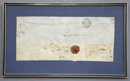
1777 French Military Commission DocumentSchmidt's Antiques Inc. Since 19114.8(431)See Sold PriceMar 02, 2024
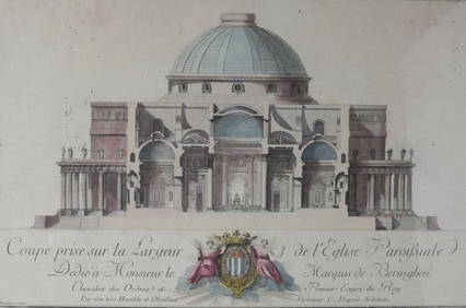
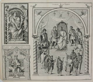
Charles Dupuis French 18th century, Pair Hand Colored Engravings, ArchitecturalGlobal Auctions Company4.3(36)See Sold PriceMar 03, 2024
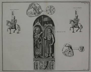
Bernard de Montfaucon c1730 Engraving Les monuments deGlobal Auctions Company4.3(36)See Sold PriceMar 03, 2024
Bernard de Montfaucon c1730 Engraving Les monuments deGlobal Auctions Company4.3(36)See Sold PriceMar 03, 2024
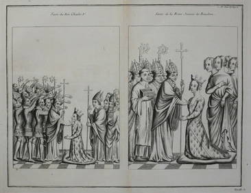
Bernard de Montfaucon c1730 Engraving Les monuments de la monarchie francaiseGlobal Auctions Company4.3(36)See Sold PriceMar 03, 2024
Bernard de Montfaucon c1730 Engraving Les monuments deGlobal Auctions Company4.3(36)See Sold PriceMar 03, 2024
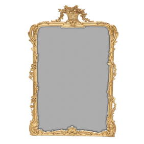
Carver's Guild Panier de Fleur II Rectangular Gold Gilt MirrorNorthgate Gallery, Inc.4.5(34)See Sold PriceMar 02, 2024
1758 MAP PARTIE DE LA MER GLACIALE contenants La Nouvelle Zemble RUSSIA antiqueJasper524.5(9.8k)See Sold PriceFeb 27, 2024
1748-1755 SERMONS by SAURIN 11 VOLUMES antique in FRENCH 18th CENTURYJasper524.5(9.8k)See Sold PriceFeb 27, 2024
Photograph album of over 240 silverprints of Rio & Brazil 1944PBA Galleries4.7(381)See Sold PriceMar 07, 2024
La Basse-Guinée… Loango, Congo, AngoIa & Benguela Southern Africa BONNE 1790 mapJasper524.5(9.8k)See Sold PriceFeb 28, 2024
États du Roi de Maroc… d’Alger, Tunis & Tripoli. North Africa. BONNE 1790 mapJasper524.5(9.8k)See Sold PriceFeb 28, 2024
Le Canal de Mosambique, l'Isle de Madagascar… Mozambique. Africa. BONNE 1788 mapJasper524.5(9.8k)See Sold PriceFeb 28, 2024
Royaumes, Etats et Pays de la Haute Guinée. Gulf of Guinea. BONNE 1788 old mapJasper524.5(9.8k)See Sold PriceFeb 28, 2024
Le Royaume d’Adel… Ajan & Zanguebar. Adal Ajuran. Kenya Tanzania. BONNE 1788 mapJasper524.5(9.8k)See Sold PriceFeb 28, 2024
Le Canal de Mosambique, l'Isle de Madagascar… Mozambique. Africa. BONNE 1790 mapJasper524.5(9.8k)See Sold PriceFeb 28, 2024
Partie Occidentale de l’Afrique. West Africa coast Canary islands BONNE 1788 mapJasper524.5(9.8k)See Sold PriceFeb 28, 2024
Le Royaume d’Adel… Ajan & Zanguebar. Adal Ajuran. Kenya Tanzania. BONNE 1790 mapJasper524.5(9.8k)See Sold PriceFeb 28, 2024
États du Roi de Maroc… d’Alger, Tunis & Tripoli. North Africa. BONNE 1788 mapJasper524.5(9.8k)See Sold PriceFeb 28, 2024
La Basse-Guinée… Loango, Congo, AngoIa & Benguela Southern Africa BONNE 1788 mapJasper524.5(9.8k)See Sold PriceFeb 28, 2024
1774: AN ANTIQUE ILLUSTRATED TWO-VOLUME HISTORY OF PERUVIAN DISCOVERY AND CONQUEST WITH MAPNY Elizabeth 4.3(84)See Sold PriceMar 03, 2024
IN FRENCH, L'ELOGE DE LA FOLIE ANCIENT WAS ILLUSTRATED BY ERASMUS IN 1777.NY Elizabeth 4.3(84)See Sold PriceMar 03, 2024
1792 OLD INDIA HISTORY ANTIQUE ILLUSTRATED WITH MAPS OF THE EIGHTEENTH CENTURY IN FRENCHNY Elizabeth 4.3(84)See Sold PriceMar 03, 2024