SoldWWII 1944 DATED UK NAVIGATION CHARTS & MAPS LOTWWII 1944 DATED UK NAVIGATION CHARTS & MAPS LOT Lot of numerous 1944 dated UK British military navigation charts and maps. North Queensland, New Guinea, Java navigation chart, Manado, Formosa, f-8 LonSee Sold Price
SoldA group of flight navigation chartsPan American Airways. Hawaii and San Francisco Routes. Various sizes. See Sold Price
SoldLarge Collection of Assorted Maps and Navigation ChartsLarge Collection of Assorted Maps and Navigation Charts, vintage and new, good condition.See Sold Price
SoldWW2 USAAF Radar Navigation Charts, Japan (5pc)WW2 USAAF Radar Navigation Charts, Japan (5pc). This lot includes 5 Radar Navigation Charts prepared by the 949th Engineer Aviation Topographical Company" of the following: (1) Radar Navigation Chart-See Sold Price
SoldSolar System & Phases of Moon Framed ChartsCHARTS. Lot of two, Solar system and phases of the moon charts framed, illuminated, fair condition, 10.5"h x 8.25"w - 8.25"h x 10.5"wSee Sold Price
SoldAntique Navigation Chart of Grand Ocean, 1818Map: Carte Reduite du Grand Ocean comprise L'Asie et L'Amerique Date Printed: 1818 Cartographer: Depot de la Marine Size: 35 x 24 Condition: Good condition. Some browning and finger marks but overallSee Sold Price
SoldWWII NAZI GERMAN LUFTWAFFE NAVIGATION CHART MAPA single sided yellow section of map that measures approximately 42 X 49 inches with vibrant colors. This Luftwaffe navigational map covers Western Europe and her Ocean waters and is yellow in tent soSee Sold Price
SoldEarly Man in the United States Framed ChartEarly Man in the United States Framed ChartSee Sold Price
SoldUlfert Wilke lithograph "Navigation Chart"Artist: Wilke, Ulfert (German/American 1907–1987) Title: Navigation Chart Date: 1972 Medium: lithograph printed in colors Dimensions: 25 x 19 inches Editions: 2 of 20 Signature: penciSee Sold Price
SoldFramed chart of Nantucket and Martha’s VineyardCopy of an early 1900s George W. Eldridge chart of Nantucket and Martha’s Vineyard. Mounted into a rich burlwood frame. 33” tall x 52” longSee Sold Price
SoldWWII NAZI GERMAN LUFTWAFFE NAVIGATION CHART MAPA double sided yellow section of map that measures approximately 42 X 32 inches with vibrant colors and has no damage whatsoever. This Luftwaffe navigational map covers Western Europe and her Ocean waSee Sold Price
SoldA Maritime navigation chart for the Bengal 'EasternA Maritime navigation chart for the Bengal 'Eastern Channel', pub. 1806, and 3 papers from 'Captain Manby's plan for saving the lives of ship-wrecked mariners', 17½'' x 25''See Sold Price
SoldWWII NAZI GERMAN LUFTWAFFE NAVIGATION CHART MAPA double sided section of map that measures approximately 30 X 34 inches with vibrant colors and has no damage whatsoever. This Luftwaffe navigational map covers Western Europe and her Ocean waters.See Sold Price
SoldFramed chart of Nantucket SoundCirca 1958, ocean chart showing “Nantucket Sound and Approaches”. Also shows the south coast of Cape Cod from Buzzard’s Bay to Chatham including Monomoy Island. Framed in a painted silver moldinSee Sold Price
SoldCommon Breed of Beef & Dairy Cow" Framed Chart 32 1/4"Common Breed of Beef & Dairy Cow" Framed Chart 32 1/4" x 24 1/2See Sold Price
SoldFramed chart of Marblehead, Salem, MAMatted and framed copy of an Eldridge chart showing Marblehead, Salem, Beverly, Manchester, Magnolia and Prides Crossing. Chart shows suggested routes, depths in Fathoms and due north. 30" tall x 38"See Sold Price
SoldFramed Chart of the Island of NantucketFramed chart of the island of Nantucket. Copy of original by Walker. Dimensions: 26"H x 34"L. Condition: very goodSee Sold Price
SoldFramed Chart of Nantucket IslandFramed chart of Nantucket Island from the American Neptune Society. Topographical map of Nantucket with legend at lower right. This is a copy distributed by Haley and Steele of Newbury Street, Boston.See Sold Price
SoldSet of 3 Framed Antique Moon & Celestial Chart PrintsSet of three framed space-related charts. These gorgeous framed charts show the moon, meteorites, and celestial globes. The illustrations are beautifully detailed with tiny stars and showers of light.See Sold Price
SoldLARGE INTERESTING GROUPING OF KOREAN WAR VINTAGENAVY UNIFORMS, AERIAL NAVIGATION CHARTS, AVIATION RELATED PERIODICALS & MANUALS. Items from 2 Brothers who served in the US Navy. Included: brass/bronze wall plaque having dark greenish patina appearaSee Sold Price
SoldWWII Military Maps and EphemeraFrance road maps, long range air navigation chart (large map), and other maps.See Sold Price
SoldChart depicting Early Man Flint Types34 ½" x 24" Framed Chart depicting Early Man Flint Types of the United States ChronologicallySee Sold Price
SoldMarblehead to Newburyport chartFramed chart “I” by George Eldridge showing the Massachusetts Coast from Marblehead to Newburyport. This copy is made from 1908 original and is framed in burlwood. Coastal towns include Salem, SwaSee Sold Price
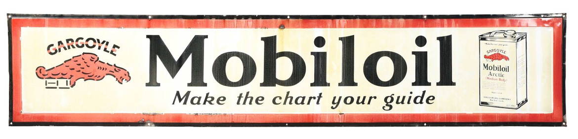
MOBILOIL "MAKE THE CHART YOUR GUIDE" PORCELAIN SIGN W/ OIL CAN & GARGOYLE GRAPHIC.Dan Morphy Auctions4.2(1.3k)See Sold PriceFeb 24, 2024
LATE 18TH C. VERY LARGE CHART OF NORTHEAST CANADA BY DES BARRES (1721-1824), 1780, FRAMEDThomaston Place Auction Galleries4.4(394)See Sold PriceFeb 24, 2024
RARE 1638 HONDIUS MAP OF BERMUDA, FRAMEDThomaston Place Auction Galleries4.4(394)See Sold PriceFeb 24, 2024
LARGE EARLY 18TH C. DUTCH CHART OF UPPER NORTH AMERICA, PIERRE MORTIER (1661-1711), FRAMEDThomaston Place Auction Galleries4.4(394)See Sold PriceFeb 24, 2024
17TH C. ENGLISH CHART OF THE THAMES BY CAPT. GREENVILLE COLLINS, 1693-4, FRAMEDThomaston Place Auction Galleries4.4(394)See Sold PriceFeb 24, 2024
CHART "LONG ISLAND SOUND FROM NEW YORK TO MONTOCK POINT ..." New York, 1830 21" x 77" sight. FramedEldred's4.7(423)See Sold PriceFeb 27, 2024
CHART "SOUTHERN COAST OF LONG ISLAND FROM MONTAUK POINT TO EAST HAMPTON" Circa 1877 11.25" x 22.75"Eldred's4.7(423)See Sold PriceFeb 27, 2024
Magnificent Antique French Impressionist Countryside Chicken Farm Framed Original Oil PaintingCurated Gallery Auctions4.6(138)See Sold PriceFeb 25, 2024
Antique American Hudson River School Sunset Landscape Framed Original Oil PaintingCurated Gallery Auctions4.6(138)See Sold PriceFeb 25, 2024
Norman C. Black (1920-1999) Antique Indian Surrealist Landscape Framed Original Oil PaintingCurated Gallery Auctions4.6(138)See Sold PriceFeb 25, 2024
Large Antique Native American Indian Chief Male Portrait Framed Original Oil PaintingCurated Gallery Auctions4.6(138)See Sold PriceFeb 25, 2024
Antique California Coastal Beach Scene Pacific Ocean Framed American Impressionist Oil PaintingCurated Gallery Auctions4.6(138)See Sold PriceFeb 25, 2024
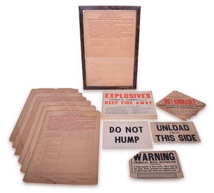
32 Railroad Loading Charts and Explosive Placards - Monon, Illinois Central, Northern Pacific, etc.Rail & Road Auctions4.6(165)See Sold PriceMar 08, 2024
frank sinatra "songs for swingin' lovers" vinyl record & cover professionally framed 17.5? x 26.5?3 Kings Auction4.1(205)See Sold PriceFeb 24, 2024
led zeppelin "led zeppelin i" vinyl record & cover professionally framed 17.5? x 26.5? display withGolden Air Auctions4.3(267)See Sold PriceFeb 29, 2024