SoldFour matted hand colored township maps,Four matted hand colored township maps, late 19th C., which include Marlborough and Lederachsville Combination Atlas map, Gilbertville and Douglas, Lower Salford and Marlborough with COA, and MorelandSee Sold Price
SoldThree matted hand colored township maps,Three matted hand colored township maps, late 19th C., two combination atlas maps of Montgomery County, which includes Upper Hanover Palm Station with COA, New Hanover, Zieglersville, Limerick SquareSee Sold Price
Sold(2) 19TH CENTURY NEW ENGLAND MAPSIncludes: "City and Township Map of Vermont and New Hampshire", handwritten on reverse "R165 1887 LHC Mitchell 25.00"; copyright 188_ W. Bradley & Co.; hand colored; matted under plastic sheeting; cenSee Sold Price
SoldFrench School (19th Century)"French Wine DistrictsFrench School (19th Century) "French Wine Districts", suite of four hand-colored maps, sight 13" x 20", by Levasseur, 1852, Paris. Glazed, matted and presented in carved stained and parcel-gilt framesSee Sold Price
SoldFour Hand-Colored Maps of DelawareA grouping of four hand-colored maps of Delaware, to include a "Plan of Wilmington and its Environs", "A Geographical, Historical, and Statistical Map of Delaware", and two smaller colored maps. LargeSee Sold Price
SoldA Group of Four Hand Colored Map Engravings by JohnA Group of Four Hand Colored Map Engravings by John Ogilby (British, 1600-1676),Depicting roads to and from London.Plate dimensions: H: 12 1/4 x W: 17 1/4 in.Framed dimensions: H: 20 3/4 x W: 25 1/8 iSee Sold Price
SoldFramed and matted hand-colored map of North AmericaFramed and matted hand-colored map of North America dated 1763. Site-11.5"h.x15.5"w.See Sold Price
SoldFramed and matted hand colored map of the Province ofFramed and matted hand colored map of the Province of Massachusetts Bay, etc., published London by J. Bew, 1782. 11" x 14.5"See Sold Price
Large framed and matted hand-colored map of FrancLarge framed and matted hand-colored map of France by Nocolaum Visser, c.1680, with extensive detailing. 23”x29”See Sold Price
SoldFramed and matted hand-colored map of France “Nicolaum Framed and matted hand-colored map of France “Nicolaum Visser”, 1680. 23”x29”See Sold Price
SoldMitchell’s New General Atlas.[Maps] Mitchell’s New General Atlas. Philadelphia: S. Augustus Mitchell, Jr., 1861. Publisher’s three-quarter leather over gilt-stamped cloth boards. Seventy-four hand-colored maps and plaSee Sold Price
SoldMitchell, Samuel Augustus. A New Universal AtlasMitchell, Samuel Augustus. A New Universal Atlas of the World. Philadelphia: Thomas Cowperthwait & Co., 1852. Folio, disbound, with seventy of seventy-four hand-colored maps, lacking New Hampshire andSee Sold Price
Sold[Maps]. Jean Baptiste Nolin. Collection of Four[Maps]. Jean Baptiste Nolin. Collection of Four Hand-Colored Maps. Paris: Chez Daumont, 1See Sold Price
[Maps]. Jean Baptiste Nolin. Collection of Four[Maps]. Jean Baptiste Nolin. Collection of Four Hand-Colored Maps. Paris: Chez Daumont, 1See Sold Price
Four Bible Maps by American Tract SocietyThis 8vo (5.75 x 8.75 inch) pamphlet in printed paper wraps has four hand colored maps. They are entitled as follows: Map of All the Countries Named in the Bible, by Geo. E. Sherman, (8.75 x 10.75); pSee Sold Price
SoldHand Colored Map of St. Georges ChannelFramed and matted hand colored map of St. Georges Channel and the Irish Sea, R.W. Seale 19" x 15" sight size / 25" x 21" overall Condition: some creasing, not examined out of the frameSee Sold Price
SoldLarge framed mapLarge framed and matted hand colored map of North America by "A. Walker" and engraved by "R.W. Seale". Sight 32.5" x 34.25"See Sold Price
SoldA Group of Four Hand-colored Engraved Maps, 19th/20thA Group of Four Hand-colored Engraved Maps, 19th/20th Century, Including three maps by Gerardus Mercator depicting Austria Archiducatus, Saltzburg and Flanders, and one map by Frederick de Wit depictiSee Sold Price
SoldSet of four hand colored engraved maps, state of Ohio,Set of four hand colored engraved maps, state of Ohio, Virginia, Maryland and Delaware, early 19th century. sight size: 16 1/2" x 9 1/2" to 15" x 19 1/4".See Sold Price
SoldFour Antique Hand Colored MapsA grouping of four small framed hand-colored engraved maps to include New England and New York by John Seller, A Mapp of the World by John Seller, Terra Firma, and Moscovia (Moscow) of Russia. All inSee Sold Price
SoldFour Hand Colored, Engraved Maps from Mitchell'sFour Hand Colored, Engraved Maps from Mitchell's General Atlas (1862), Pages 8, 40, 40, 45.Includes:Map of Canada West in Counties (1860);Map of Oregon, Washington and Part of British Columbia (1860);See Sold Price
SoldSuite of Four Hand-Colored Engraved MapsSuite of Four Hand-Colored Engraved Maps, by Homann Heirs, published Nuremberg, 1736/1750, of various princedoms of Silesia (Poland), sight 24" x 34". All glazed and framed.See Sold Price
SoldSuite of Four Hand-Colored Engraved Maps, by Homann HeiSuite of Four Hand-Colored Engraved Maps, by Homann Heirs, published Nuremberg, 1736/1750, of various princedoms of Silesia (Poland), framed, H.- 24 in., W.- 34 in.See Sold Price
SoldSet of Four Vintage Hand Colored MapsFour vintage hand colored etchings of maps. Including "The Rout Hannibal Took Through Gaul & Over the Alpes into Italy," "Syria After the Death of Alexander the Great," "Great Greece, Sardinia, CorsicSee Sold Price
MARTINET / DE VRIES Catechism of Nature 4 Vol. Set c1788 Engravings Rare!Luis Porretta Fine Arts4.3(10)See Sold PriceMar 02, 2024
17TH C. ANTIQUE MAP SIEGE OF LA ROCHELLE, FRANCE, FRAMEDThomaston Place Auction Galleries4.4(386)See Sold PriceFeb 24, 2024
18TH C. ANTIQUE MAP: FRENCH & INDIAN WAR, FRAMEDThomaston Place Auction Galleries4.4(386)See Sold PriceFeb 24, 2024
17TH C. ENGLISH LINEAR MAP BY OGILBY, FRAMEDThomaston Place Auction Galleries4.4(386)See Sold PriceFeb 24, 2024
PIETER SCHENK / VALK / JANSSEN Hand Colored Map of Rhodes Greece ca1702 vgcLuis Porretta Fine Arts4.3(10)See Sold PriceMar 02, 2024
Hand Colored Map of the city of Amsterdam 1720Global Auctions Company4.3(36)See Sold PriceMar 03, 2024
[ARCTIC]. BOWEN, Emanuel. A New & Accurate Map of the North...Potter & Potter Auctions4.6(538)See Sold PriceMar 07, 2024
[MAPS]. DUFOUR, Auguste-Henri (1795-1865). Bound Volume of ...Potter & Potter Auctions4.6(538)See Sold PriceMar 07, 2024
Johann Homann Hand-Colored Map Engraving, c. 1730Auctions at Showplace4.5(723)See Sold PriceMar 17, 2024
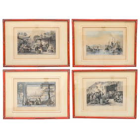
Hand-Colored Engravings of Thomas Allom Drawings, Group of FourNorthgate Gallery, Inc.4.4(34)See Sold PriceMar 02, 2024
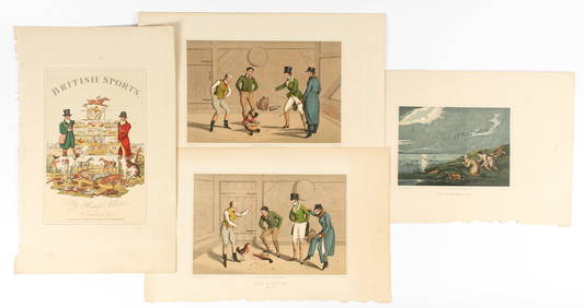
Henry Alken, The National Sports of Great Britain, Four Hand Colored Engravings Ca. 1821Hoch LTD.4.6(70)See Sold PriceFeb 25, 2024
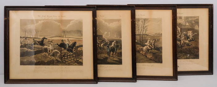
After H. Alken, Group of 4 Steeplechase PrintsOld Kinderhook Auction Company4.6(217)See Sold PriceMar 05, 2024
Galliae Regionis Nova Descriptio Hand Colored Map of France on Laid Paper, Ca. 16th Century, H 10" WDuMouchelles4.6(822)See Sold PriceMar 15, 2024


![[Maps]. Jean Baptiste Nolin. Collection of Four (1 of 1)](https://p1.liveauctioneers.com/906/86613/44530529_1_x.jpg?height=282&quality=70&version=1458833675)
![[Maps]. Jean Baptiste Nolin. Collection of Four (1 of 1)](https://p1.liveauctioneers.com/906/80657/41935123_1_x.jpg?height=282&quality=70&version=1445283342)


![[ARCTIC]. BOWEN, Emanuel. A New & Accurate Map of the North... (1 of 1)](https://p1.liveauctioneers.com/928/318880/171360917_1_x.jpg?height=282&quality=70&version=1707501302)
![[MAPS]. DUFOUR, Auguste-Henri (1795-1865). Bound Volume of ... (1 of 2)](https://p1.liveauctioneers.com/928/318880/171361279_1_x.jpg?height=282&quality=70&version=1707501302)