SoldCollection of (4) French Map PrintsSeries of four European maps of France, in French, all appear to be hand-colored and framed consistently.Overall size: 19 3/4 x 20 1/4 in. Sight size: 12 x 13 1/2 in. Please note that all sales are fiSee Sold Price
FRAMED CONTINENTAL MAPSThree: Jerusalem (after Juan Bautista Villalpando), eight 3" x 5" maps/cityscapes from various European locations from book by Gabriel Bucelin, and a hand colored reprint of Nassovia Comitatus (RhinelSee Sold Price
SoldFour Views: Derbenta, Soltanii, Cangoxuma, GoaNicholas Visscher (1649–1702). Amsterdam, [c.1695]. Hand colored engraving. 20 3/4 x 24 3/4 inches sheet, 31 1/2 x 35 1/4 inches framed. Lots 5 & 6: Two brilliantly colored bird’s-eye views of theSee Sold Price
SoldFOUR EUROPEAN HAND COLORED ENGRAVED MAPS18th through 20th Century. Comprising, the English Counties of Devonshire and Dorsetshire, a large map of Africa and a Dutch "De L' Academi des Royale Scieneces L' Amerique'. Largest (Africa) site meaSee Sold Price
SoldThree European Hand-Colored MapsThree Antique European Hand-Colored Maps , 18th c., incl.: "The Countie and Citie of Lyncolne Described with the Armes...", 15 in. x 20 in.; "Istria olim Iapidia", 15 in. x 19 1/2 in.; and "PrincipatuSee Sold Price
SoldThree Framed Hand-Colored Maps[A New and Accurat Map of the World], by P. Kaerius/John Speed, Amsterdam, circa 1646, miniature version, 3-3/8 x 4-7/8 in. (sight), [toning]; [Tiipus Orbis Terrarum] by Phillipe Galle, circa 1574, thSee Sold Price
SoldA Group of Four Hand-colored Engraved Maps, 19th/20thA Group of Four Hand-colored Engraved Maps, 19th/20th Century, Including three maps by Gerardus Mercator depicting Austria Archiducatus, Saltzburg and Flanders, and one map by Frederick de Wit depictiSee Sold Price
SoldSet of Fine 19th Century Colored EngravingsThree framed hand colored European engravings of various presentations. Late 18th or early 19th century. No found marked or signatures. Measuring approx. 12"x 5" and 20.5" x 13.5" overall with the fraSee Sold Price
SoldSet of Fine 19th Century Colored EngravingsThree framed hand colored European engravings of various presentations. Late 18th or early 19th century. No found marked or signatures. Measuring approx. 12"x 5" and 20.5" x 13.5" overall with the fraSee Sold Price
SoldCurrier and Ives Hand-Colored Lithographs, AmericanAmerican, 19th century. Four large folio hand-colored lithographs, framed. Three with The Old Print Shop labels and one with Clossons label on reverse of frame; 18.5 x 24.25 in. (largest sight), 28.2See Sold Price
SoldThree framed Beers atlas local Dutchess County handThree framed Beers atlas local Dutchess County hand colored maps including Rhinebeck, Rhinecliff, and Red Hook. Published in 1867. Provenance: Private donation to the Northern Dutchess Hospital in RhiSee Sold Price
SoldTwenty-Four European Hand Colored Botanical EngravingsTwenty-Four European Hand Colored Botanical Engravings, after Emanuel Sweert 21-1/4 h x 16 w x 1 d inches (54.0 x 40.6 x 2.5 cm) (each, framed)See Sold Price
SoldMitchell’s New General Atlas.[Maps] Mitchell’s New General Atlas. Philadelphia: S. Augustus Mitchell, Jr., 1861. Publisher’s three-quarter leather over gilt-stamped cloth boards. Seventy-four hand-colored maps and plaSee Sold Price
SoldFour Antique Hand Colored MapsA grouping of four small framed hand-colored engraved maps to include New England and New York by John Seller, A Mapp of the World by John Seller, Terra Firma, and Moscovia (Moscow) of Russia. All inSee Sold Price
SoldJames Wyld, hand-colored mapsJames Wyld, "Map of the Countries lying between Turkey & Birmah...", London, 1839, hand-colored maps on four sheets, framed, 43 in. x 53 inSee Sold Price
SoldSET OF 3 18th CENTURY FRAMED HAND COLORED MAPSSET OF THREE 18th CENTURY FRAMED HAND COLORED MAPS OF BARBADOS, ANTILLES, JAMAICA, CIRCA 1766.See Sold Price
SoldFIVE ANTIQUE ENGRAVINGSThree antique engravings. Two framed and under glass, three unframed. four hand colored and one without color. Framed engravings measure 15 1/2" x 12 1/2". Unframed cathedral interior measures 7" x 5"See Sold Price
SoldFour 18th century maps by Zatta & Euler(lot of 4) Group of 18th century copper engraved maps, each handcolored, three maps produced under the supervision of Leonard Euler (1707-1783), the Swiss mathematician, including Regni Hiberniae (IreSee Sold Price
Four Framed Ornithological Prints. Three hand-coloFour Framed Ornithological Prints. Three hand-colored lithographs after John Gould (1804-1881): the bower bird Gould calls Ailuroedus Arfakianus, now called Ailuroedus Melanotis, or white-eared catbirSee Sold Price
SoldAntique European Map Alsatia, 15th CenturyAntique European Map Alsatia. Hand colored accents 15th century map Latin descriptions. Ca 30x24 inches framed dimensions.Frame included with purchase. Please note that this lot has a confidential resSee Sold Price
SoldFour 19th Century Hand Colored Lithographs.Four 19th Century Hand-Colored Lithographs. Three Sardny & Major and one Haskell & Allen. All are framed, largest measures 15-1/2" x 19-1/2" overall. Condition: Foxing and toning.See Sold Price
SoldA Group of Four English Handcolored Engravings ofA Group of Four English Handcolored Engravings of Parakeets, AF Lydon, each framed. Height 8 1/2 x width 6 inches (visible).See Sold Price
SoldFOUR HAND COLORED EUROPEAN ETCHINGS, 20TH C.FOUR HAND COLORED EUROPEAN ETCHINGS, 20TH C., 7" X 4 TO 8" X 7":Depicting European street scenes, various artists. Pencil signed. Framed. Includes Victor Valery, etc. From the Estate of Robert and EliSee Sold Price
SoldFive Vintage European EtchingsSet of three hand colored European city etchings with matching mounts and frames 17" by 20", Preston Cribb [1876-1937] etching of Edinburgh Castle matted and framed to 12" by 16", Rose Crosman [ChicagSee Sold Price
18TH C. ANTIQUE MAP: FRENCH & INDIAN WAR, FRAMEDThomaston Place Auction Galleries4.4(386)See Sold PriceFeb 24, 2024
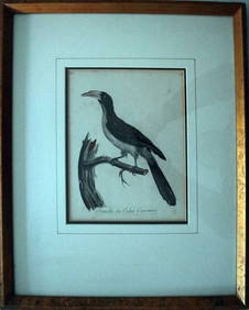
Le Valliant Crowned Hornbill Calao Couronne Rare Engraving ca1802 Framed OrnithologyLuis Porretta Fine Arts4.3(10)See Sold PriceMar 02, 2024
MARTIN VILLALBA Three Baristas Limited Ed 11/50 Engraving Hand ColoredLuis Porretta Fine Arts4.3(10)See Sold PriceMar 02, 2024
THOMAS MOULE 1837 Colored Map of Warwickshire Framed vgcLuis Porretta Fine Arts4.3(10)See Sold PriceMar 02, 2024
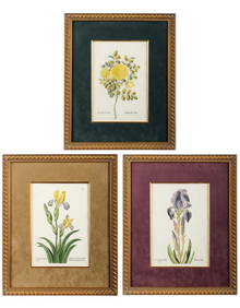
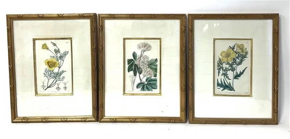
William Curtis; Three(3)19thC. English Botanical PrintsMid-Hudson Auction Galleries4.4(468)See Sold PriceFeb 24, 2024
Hand Colored Map of the city of Amsterdam 1720Global Auctions Company4.3(36)See Sold PriceMar 03, 2024
17th Century Hand Colored Engraved Map of GermanyGlobal Auctions Company4.3(36)See Sold PriceMar 03, 2024
18th Century Hess Germany Hand colored Engraved MapGlobal Auctions Company4.3(36)See Sold PriceMar 03, 2024
[ARCTIC]. BOWEN, Emanuel. A New & Accurate Map of the North...Potter & Potter Auctions4.6(539)See Sold PriceMar 07, 2024
Willem Blaeu, Etc. 17th C. Antiquarian Maps, 2Auctions at Showplace4.5(726)See Sold PriceMar 17, 2024
Framed Hand Colored Antique Map of the Department of Nord, FranceDonny Malone Auctions4.5(1.7k)See Sold PriceMar 04, 2024
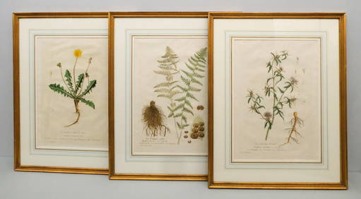
Georg Wolfgang Knorr (German, 1705-1761), Three Antique Hand Colored Botanical Engravings ofHoch LTD.4.5(73)See Sold PriceFeb 25, 2024
Pascal's Collection de fleurs... - Volume with 48 Originally Hand-colored LithographsTrillium Antique Prints & Rare Books4.5(30)See Sold PriceFeb 24, 2024
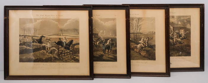
After H. Alken, Group of 4 Steeplechase PrintsOld Kinderhook Auction Company4.6(217)See Sold PriceMar 05, 2024
GROUP OF FOUR ANTIQUE HAND COLORED STEEL ENGRAVINGS OF FRENCH FASHIONChamberlain's Auction Galleries4.4(50)See Sold PriceFeb 24, 2024
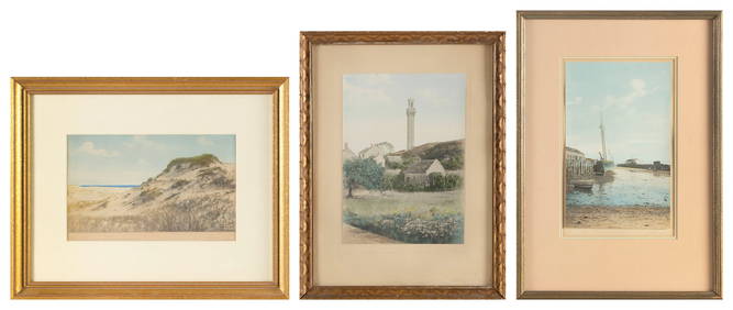
ROBERT WINSLOW (America, Early 20th Century), Three Provincetown views:, Hand-colored photographs,Eldred's4.7(409)See Sold PriceMar 07, 2024
ANTIQUE FRENCH HAND COLORED INTERIOR DESIGN PRINTAntique Arena Inc.4.5(852)See Sold PriceMar 09, 2024


![[ARCTIC]. BOWEN, Emanuel. A New & Accurate Map of the North... (1 of 1)](https://p1.liveauctioneers.com/928/318880/171360917_1_x.jpg?height=282&quality=70&version=1707501302)