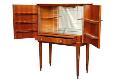
Elevate your home with this exquisite 1950's bar cabinet by Förenades Möbler of Linköping,Magic Hill, LLC4.5(34)See Sold PriceMar 27, 2024
Forlani Engraved Map of Italy, 1569FORLANI, Paolo (fl. 1560-1571) ; GASTALDI, Giacomo (c. 1500-1566). [Italy] [Ded. to Carlo Vicentino] Al Molto magno. et exccellmo Sigor. Carlo Vicentino sup sigor sempre ossexmo. Tra Ie piu belle e plSee Sold Price
SoldForlani Map of Italy 1569FORLANI, Paolo (fl. 1560-1571) ; GASTALDI, Giacomo (c. 1500-1566).[Italy] [Ded. to Carlo Vicentino] Al Molto magno. et exccellmo Sigor. Carlo Vicentino sup sigor sempre ossexmo. Tra Ie piu belle e pluSee Sold Price
SoldCarta Geografica, Ducato di SavoiaPaolo Forlani. engraved map. Venice: Ferdinando Bertelli, 1562. 20 1/4 x 26 inches, 29 3/4 x 35 1/8 inches Framed. Only the second printed map of the Savoy region in Italy.See Sold Price
SoldForlani map of the MediterraneanFORLANI, Paolo (fl. 1560-1571), compiled by Diogo Homem. >br> La carta del navigare...dell'Europa, et parte dell'Africa, et dell'Asia. Engraved map. Venice: 1569. 21" x 31 7/8" sheet, 32 1/2" x 43 1/2See Sold Price
SoldForlani City View of GenevaFORLANI, Paolo (fl. 1560 - 1571).Ginevra [Geneva, Switzerland].Engraved map.Venice, 1567 (1569).10 3/4" x 16 1/4" sheet, 20" x 25 1/2" framed.A highly rare and finely engraved 16th century map of GeneSee Sold Price
Untitled map of GenevaPaolo Forlani (Italy, fl.1560 - 1574). Venice, 1567. 10 6/8 x 16 2/8 inches. A highly rare and finely engraved Sixteenth-Century map of Geneva. These city views for Forlani’s famous atlas are the fiSee Sold Price
SoldHANDCOLORED ENGRAVED MAP, ITALY, JACQUES CANTELLIHANDCOLORED ENGRAVED MAP, ITALY, JACQUES CANTELLI 18TH CENTURY. 20 X 26 1/2"; FRAMED & GLAZED 27 X 33" **DUE TO THE SIZE AND/OR FRAGILITY OF THIS LOT, STANDARD IN-HOUSE SHIPPING IS NOT AVAILABLE. PLEASee Sold Price
Forlani engraved map of Switzerland, 1567FORLANI, Paolo (fl. 1560-1571). [Switzerland] Helvetiam illam regionem ... Engraved map. Venice, c. 1567. 20 1/2" x 28 1/4" sheet; 32" x 39 3/4" framed. RARE. Based on the reduced re-engraving of theSee Sold Price
Forlani Engraved Map of Rome, 1563FORLANI, Paolo (fl. 1560-1571) ; BERTELLI, Ferrando (b. 1525). [Rome] Nova discrittione di tutto il territorio de Roma. Engraved map. Venice: 1563. 20 1/2" x 23 3/8" sheet; 29 5/8" x 32 5/8" framed. BSee Sold Price
SoldEngraved Map of ItalyEngraved Map of Italy, hand-colored copper engraving, after Baptiste Homann, 1752, titled in decorative cartouche upper middle "Regia Celssitudinis Sabaudicae Status in quo Ducatus Saubaudiae PrincipaSee Sold Price
SoldEngraved Map of ItalyEngraved Map of Italy, hand-colored copper engraving, after Baptiste Homann, 1752, titled in decorative cartouche upper middle "Regia Celssitudinis Sabaudicae Status in quo Ducatus Saubaudiae PrincipaSee Sold Price
De L'Isle Philippe Buache engraved map of Italy 1802Important map of Guillaume de L'Isle corrected by Philippe Buache and edited by Dezauche in 1800 ,the Venetian Republic is still intact , The city state suffered defeats from the navy of the Ottoman ESee Sold Price
De L'Isle Philippe Buache engraved map of Italy 1802Important map of Guillaume de L'Isle corrected by Philippe Buache and edited by Dezauche in 1800 ,the Venetian Republic is still intact , The city state suffered defeats from the navy of the Ottoman ESee Sold Price
De L'Isle Philippe Buache engraved map of Italy 1802Important map of Guillaume de L'Isle corrected by Philippe Buache and edited by Dezauche in 1800 ,the Venetian Republic is still intact , The city state suffered defeats from the navy of the Ottoman ESee Sold Price
De L'Isle Philippe Buache engraved map of Italy 1802Important map of Guillaume de L'Isle corrected by Philippe Buache and edited by Dezauche in 1800 ,the Venetian Republic is still intact , The city state suffered defeats from the navy of the Ottoman ESee Sold Price
De L'Isle Philippe Buache engraved map of Italy 1802Important map of Guillaume de L'Isle corrected by Philippe Buache and edited by Dezauche in 1800 ,the Venetian Republic is still intact , The city state suffered defeats from the navy of the Ottoman ESee Sold Price
Sold(2pc) HAND-COLORED ENGRAVED MAPS OF ITALYincluding ‘Genovesato Serenissimae Reipublicae Genuensis Ducatus et Dominii Nova Descriptio, by Willem Blaeu, Amsterdam, 1634 or later; and ‘Status Mediolanensis nec non Ducatum Mantuae, MSee Sold Price
(2pc) HAND-COLORED ENGRAVED MAPS OF ITALYincluding 'Genovesato Serenissimae Reipublicae Genuensis Ducatus et Dominii Nova Descriptio', by Willem Blaeu, Amsterdam, 1634 or later; and 'Status Mediolanensis nec non Ducatum Mantuae, Modenae, ParSee Sold Price
SoldC. 1695 Giacomo Cantelli map of Italy by BARBEY[Italy] Giocomo Cantelli engraved map of Italy, c. 1695: "L'Italia con Le sue Poste e Strade Principali descritta da Giacomo Cantelli da Vignola." Engraved by Antonio Barbey, map shows the Adriatic, sSee Sold Price
SoldMAP, Italy, SansonItaly. Nicolas Sanson, Italie, from Algemeene Weereldbeschryving, 1705 (published). Hand Color. Delicately engraved map of Italy including Corsica, Sicily, and Sardinia, and extending to the Balkan coSee Sold Price
Sold1640 TABULA ITALIAE, CORSICAE,SARDINIAE,JanssonMapsGorgeous 1640 Handcolored Engraved Map of Italy by Jansson! 1640, “TABULA ITALIAE, CORSICAE, SARDINIAE...,” by Jan Jansson, Amsterdam, Choice Very Fine. 18” x 21.25”, coppeSee Sold Price
SoldForlani Map of the River DanubeFORLANI, Paolo (fl. 1560-1571) ; GASTALDI, Giacomo (c. 1500-1566).[River Danube] Map of Romania, Bulgaria and Hungary by Giacomo Gastaldi, engraved by Paulo Forlani.Engraved map, two sheets joined.VenSee Sold Price
SoldMap: L'Italia Con Le sue Poste e Strade PrincipaliAntique engraved map of Italy. Titled: L'Italia Con Le sue Poste e Strade Principali. Published by Presso la Calcografia Camerale, Rome, 1799. The map depicts the Adriatic, some of the Balkans and ProSee Sold Price
Senex (John) A New Map of ItalySenex (John) A New Map of Italy, engraved map of Italy, Sicily, Corsica and Sardinia, on 2 sheets, joined, original outline hand-colouring, large pictorial cartouche (uncoloured), 650 x 940 mmSee Sold Price
17th Century Hand Colored Engraved Map of GermanyGlobal Auctions Company4.3(36)See Sold PriceMar 03, 2024
18th Century Hess Germany Hand colored Engraved MapGlobal Auctions Company4.3(36)See Sold PriceMar 03, 2024
Hand Colored Engraved Map of Europe, Jean Baptiste Bourguignon Anville 1754Global Auctions Company4.3(36)See Sold PriceMar 03, 2024
De Jode, Rare, pub. 1593 - Map of Italy (Italiae Totius Orbis olim Domatricis Nova ExactissTrillium Antique Prints & Rare Books4.5(30)See Sold PriceFeb 24, 2024
Map: A 17thC engraved map of the British Isles titled A Generall Mapp of the Isles of GreatClaydon Auctioneers Ltd4.3(125)See Sold PriceFeb 26, 2024
Map: An 18thC engraved map of Bedfordshire titled An Accurate Map of the County of Bedford DividedClaydon Auctioneers Ltd4.3(125)See Sold PriceFeb 26, 2024
Cooke, George 1801 Antique Map. Italy, Sicily, Sardinia & CorsicaAlbion Auctions4.6(341)See Sold PriceMar 01, 2024
Blackie (Pub) 1882 Pair of Folio Maps. Italy - North & SouthAlbion Auctions4.6(341)See Sold PriceMar 01, 2024