First Printed Map to Name GalvestonFirst Printed Map to Name Galveston One of Six Maps Streeter Considered Most Important for a Texas Collection 303. &nbsSee Sold Price
Henry PoppleThe Earliest Large Scale Map of North America, the First Printed Map to Name the Thirteen Colonies, and the Best English Representation of North America Prior to John Mitchell's Landmark Map of 1755;See Sold Price
Sold-. Murray's Handbooks for Travellers.- A Hand-Book-. Murray's Handbooks for Travellers.- A Hand-Book for Travellers in Switzerlandand the Alps of Savoy and Piedmont, first edition, map printed on silk, lacking front endpaper, ownership name iSee Sold Price
SoldTolkien (J.R.R.) The Lord of the RingsTolkien (J.R.R.) The Lord of the Rings,3 vol., first editions, first impressions, vol.III third state with sagging text and printed '4' on p.49, maps, ink name on front free endpapers, originaSee Sold Price
SoldTolkien (J.R.R.) The Lord of the RingsTolkien (J.R.R.) The Lord of the Rings,3 vol., first editions, first impressions, vol.III third state with sagging text and printed '4' on p.49, maps, ink name on front free endpapers, originaSee Sold Price
Tolkien (J.R.R.) The Lord of the RingsTolkien (J.R.R.) The Lord of the Rings,3 vol., first editions, first impressions, vol.III third state with sagging text and printed '4' on p.49, maps, ink name on front free endpapers, originaSee Sold Price
SoldFirst Delineation of the New World 1928Heading: Author: Stevens, Henry N. Title: The First Delineation of the New World and the First use of the Name America on a Printed Map Place Published: London Publisher:Henry Stevens, Son and StilesSee Sold Price
First Delineation of the New World 1928Title: The First Delineation of the New World and the First use of the Name America on a Printed Map Author: Stevens, Henry N. Description: xvi, 127, [1] pp. Wiith 2 folding facsimile maps. 12½x10. mSee Sold Price
SoldEarly maps of American in facsimiileHeading: Author: Stevens, Henry N. Title: The First Delineation of the New World and the First use of the Name America on a Printed Map Place Published: London Publisher:Henry Stevens, Son and StilesSee Sold Price
Early maps of American in facsimiileHeading: Author: Stevens, Henry N. Title: The First Delineation of the New World and the First use of the Name America on a Printed Map Place Published: London Publisher:Henry Stevens, Son and StilesSee Sold Price
Early maps of American in facsimiileHeading: Author: Stevens, Henry N. Title: The First Delineation of the New World and the First use of the Name America on a Printed Map Place Published: London Publisher:Henry Stevens, Son and StilesSee Sold Price
Ruggiero (Michele) Degli Scavi di Stabia dal MDCCXRuggiero (Michele) Degli Scavi di Stabia dal MDCCXLIX al MDCCLXXXII,first edition, half-title, folding engraved map with some names printed in red, 19 plates, most folding, some partly hand-coSee Sold Price
Ruggiero (Michele) Degli Scavi di Stabia dal MDCCXRuggiero (Michele) Degli Scavi di Stabia dal MDCCXLIX al MDCCLXXXII,first edition, half-title, folding engraved map with some names printed in red, 19 plates, most folding, some partly hand-coSee Sold Price
Ruggiero (Michele) - Degli Scavi di Stabia dal MDCCXLIXfirst edition , half-title, folding engraved map with some names printed in red, 19 plates, most folding, some partly hand-coloured, little worming throughout, later vellum, folio, Naples , 1881. TheSee Sold Price
Ruggiero (Michele) - Degli Scavi di Stabia dal MDCfirst edition , half-title, folding engraved map with some names printed in red, 19 plates, most folding, some partly hand-coloured, little worming throughout, later vellum, folio, Naples , 1881. See Sold Price
First Printed Map of Detroit, c. 1764First Printed Map of Detroit, c. 1764. La Rivière du Détroit Depuis le Lac Sainte Claire jusqu'au Lac Erié. Engraved for Jacques-Nicolas Bellin (1703-72) after EnsignSee Sold Price
SoldFirst printed map of Detroit 1764Title: La Riviere du Detroit Depuis le Lac Sainte Claire jusqu’an Lac Erie Author: Bellin, Jacques Nicolas Description: Copper-engraved map, slight hand-coloring (later). 21x32 cm. (8½x12½").The fSee Sold Price
This is the first printed map to show AlaskaQuivirae Regnu, Cum Alija Versus Borea. Cornelis De Jode (1568-1600). Engraved map with original hand color in full. Antwerp: Arnold Coninx for Fornelis De Jode, 1593. 17 4/8 x 11 4/8 inches sheet, 29See Sold Price
SoldMAP OF NEW ENGLAND'Nova Belgica et Anglia Nova', by Willem Blaeu (1571-1663), hand-colored engraving, after a manuscript map by Adriaen Block, see Burden 241: 'First printed map that depicts canoes and North American fSee Sold Price
SoldOne of the most sought after maps of theCOLTON, Joseph H. (1800 - 1893). Nebraska and Kansas. Lithograph with original hand color. New York: 1857.31" x 22 3/4" sheet. 39 1/4" x 31 3/4" framed. Colton's map is the first printed map to show tSee Sold Price
Moll: Antique Map of Peypses or Pepys Island, 1699Title/Content of Map: First printed map of Peypses or Pepys Island Date Printed: 1699 Cartographer: Moll, Herman Size (inches): 5 x 6 Four scarce views on one sheet based on a manuscipt maps drawn bySee Sold Price
Sold1633 Map Nova Virginiae Tabula - Henricus HondiusNova Virginiae Tabula map by Henricus Hondius (1597-1651). Undated, published circa 1633. This map is the 5th derivative of John Smith's 1612 map of Virginia, which was the first printed map of the ChSee Sold Price
[MAP]. ORTELIUS, Abraham. Maris Pacifici. 1589“First Printed Map to be Devoted to the Pacific Ocean” (Burden) A Peninsular California—1589 347. &nbSee Sold Price
SoldMARIS PACIFICI quod vulgo MAR del SUDMARIS PACIFICI quod vulgo MAR del SUD Map Maker: Abraham Ortelius Date: 1603 Place: Antwerp Color: Colored 17” x 21” (43 cm x 53 cm) WRITE UP: The First Printed Map of the Pacific OSee Sold Price
1818 RARE Geography Made Easy MAPS Jedidiah Morse Boston Indians Atlas AsiaSchilb Antiquarian Rare Books4.8(428)See Sold PriceMar 31, 2024
Putnam - First Map of the State of Ohio by Rufus PutnamTrillium Antique Prints & Rare Books4.5(32)See Sold PriceFeb 24, 2024
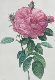
Redoute, Rare, Large Folio - Rose - Rosa Gallica flore giganteoTrillium Antique Prints & Rare Books4.5(32)See Sold PriceFeb 24, 2024
THE DARK KNIGHT RISES (2012) - "Andy Thompson" Gotham City Airplane TicketPropstore4.2(6)See Sold PriceMar 14, 2024
Afrique. Partie du Sahara #16. Niger & Chad Libya. VANDERMAELEN 1827 old mapJasper524.5(9.9k)See Sold PriceFeb 28, 2024
Afrique. Partie du Désert de Sahara #13. Mauritania Mali. VANDERMAELEN 1827 mapJasper524.5(9.9k)See Sold PriceFeb 28, 2024
Afrique Pays… sud du Lac Tchad 30 Central African Republic VANDERMAELEN 1827 mapJasper524.5(9.9k)See Sold PriceFeb 28, 2024
Afrique. Partie du Sahara #12. Mauritania. Western Sahara. VANDERMAELEN 1827 mapJasper524.5(9.9k)See Sold PriceFeb 28, 2024
Afrique. Benguela #44. Southern Angola & Northern Namibia. VANDERMAELEN 1827 mapJasper524.5(9.9k)See Sold PriceFeb 28, 2024
Afrique. Bambara #20 Niger River. Western Mali. Mauritania VANDERMAELEN 1827 mapJasper524.5(9.9k)See Sold PriceFeb 28, 2024
WAGNER COSIMA: (1837-1930)International Autograph Auctions Europe S.L.4.5(52)See Sold PriceMar 13, 2024
WILSON EDITH: (1872-1961)International Autograph Auctions Europe S.L.4.5(52)See Sold PriceMar 13, 2024
KENNEDY JACQUELINE: (1929-1994)International Autograph Auctions Europe S.L.4.5(52)See Sold PriceMar 13, 2024
NEHRU JAWAHARLAL: (1889-1964)International Autograph Auctions Europe S.L.4.5(52)See Sold PriceMar 13, 2024


![[MAP]. ORTELIUS, Abraham. Maris Pacifici. 1589 (1 of 3)](https://p1.liveauctioneers.com/514/20078/6859797_1_x.jpg?height=282&quality=70)