Sold(European Regional, Germany), Three maps: Mejer, J(European Regional, Germany), Three maps: Mejer, Johannes, Comitatus Pinnenberg, [Amsterdam], c. 1650, originally published in Danckwerth?s atlas and the in Blaeu's Atlas Minor, double-page with laterSee Sold Price
SoldThree Maps by A. J. Johnson, consisting of "NewThree Maps by A. J. Johnson, consisting of "New Brunswick, Nova Scotia, Newfoundland, and Prince Edward Island," 1860-1863, hand colored, H.- 13 3/8 in., W.- 17 in.; "Prussia and Germany," 1866, handSee Sold Price
SoldThree Early German Maps of EuropeThree early European maps, created in Germany, depicting Deutschland (Germany) and Frankreich (France) and Europa (Europe) each measures approx. 16" x 12" ID all in matching framesSee Sold Price
SoldThree 17th century European mapsThree 17th century European maps: John Speede, [Breknoke, Both Shyre and Towne described], published by J. Sudbury and G. Humbell, London, 1610, frame windowed on reverse to show text, 16 x 21-1/4 in.See Sold Price
Course of the Rhine from Worms to Bonn. RegionalTitle: Course of the Rhine from Worms to Bonn. Regional Germany 1762 by Homann Heirs Date/Period: 1762 Materials: Copper plate engraved Size: 24 x 20 1/2" 1762, by J. B. Homann & Homann Heirs, from "ASee Sold Price
Course of the Rhine from Worms to Bonn. RegionalTitle: Course of the Rhine from Worms to Bonn. Regional Germany 1762 by Homann Heirs Date/Period: 1762 Materials: Copper plate engraved Size: 24 x 20 1/2" 1762, by J. B. Homann & Homann Heirs, from "ASee Sold Price
Course of the Rhine from Worms to Bonn. RegionalTitle: Course of the Rhine from Worms to Bonn. Regional Germany 1762 by Homann Heirs Date/Period: 1762 Materials: Copper plate engraved Size: 24 x 20 1/2" 1762, by J. B. Homann & Homann Heirs, from "ASee Sold Price
Course of the Rhine from Worms to Bonn. RegionalTitle: Course of the Rhine from Worms to Bonn. Regional Germany 1762 by Homann Heirs Date/Period: 1762 Materials: Copper plate engraved Size: 24 x 20 1/2" Description: 1762, by J. B. Homann & Homann HSee Sold Price
Course of the Rhine from Worms to Bonn. RegionalTitle: Course of the Rhine from Worms to Bonn. Regional Germany 1762 by Homann Heirs Date/Period: 1762 Materials: Copper plate engraved Size: 24 x 20 1/2" Description: 1762, by J. B. Homann & Homann HSee Sold Price
Seat of the War Between Germany & France Map, 1870Map: Seat of the War Between Germany and France. 1870. Rare Advertising Map of Franco-Prussian War Publication Date: 1870 ca. Authors: GERMANIA FIRE INSURANCE COMPANY, HIGGINSON, J. H. Publisher: GERMSee Sold Price
SoldSouthern Germany regional area includes parts ofTitle: Southern Germany regional area includes parts of Switzerland. ‘Circuli Sueviae’. 1762 by Homann Heirs Date/Period: 1762 Materials: Copper plate engraved Size: 24 x 20 1/2" 1762, by J. B. HoSee Sold Price
Southern Germany regional area includes parts ofTitle: Southern Germany regional area includes parts of Switzerland. ‘Circuli Sueviae’. 1762 by Homann Heirs Date/Period: 1762 Materials: Copper plate engraved Size: 24 x 20 1/2" 1762, by J. B. HoSee Sold Price
SoldLOT OF 6: LARGE PATTERN GERMAN KNIVES IN 1, 2, 3, 4,(A) J.A. ROEHLE SOLIGEN. 4 - 1/2" two blade lock back with swing guard. Handled in genuine stag, lock is solid, knife is in excellent condition. (B) VOM CLEFF & CO GERMANY. 4" three blade Anglo SaxonSee Sold Price
Germany (Deutschland) II Eastern Part Ofbthe PrussianTitle/Content of Map: Germany (Deutschland) II Eastern Part Ofbthe Prussian States. Date: 1832-12-15 Cartographer: WALKER, J.& C. Publisher: Baldwin & Cradock/S.D.U.K. Size: 15.5Height - 12.25Width BaSee Sold Price
Colton: Antique Map of Northern Germany, 1861Title/Content of Map: Germany's Northern Central area. Hamburg & Breman Date Printed: 1861 Cartographer: J. H. Colton Material/Medium: Paper Size: 17 1/2" x 13 1/2" Hand colored. Steel engraved. FromSee Sold Price
Great 1860s school atlas physical map of EuropeFascinating map shows three different profiles of the physical nature of the European continent. A nice presentation and a very sound, clean map. From J. H. Colton’s 1864 edition of his School ASee Sold Price
Homann: Antique Map of Germany, Poland, Austria, 1753Map: 1753 Homann Map of Germany, Poland, Austria -- Imperii Romano-Germanici in svos Status et Circulos divisi Tabula Generalis in Usus Iuventutis eru diendae… Cartographer: J. Homann Year / Place:See Sold Price
Sold1856 Map of Germany No.1 Colton Germany No. 1. (with) two inset maps: Hamburg and Bremen. Published By J.H. Colton & Co. No. 172 William St. New York. Entered ... 1855 by J.H. Colton & Co. ... New York. No. 12. Author: GW ColtoSee Sold Price
SoldColton: Antique Map of Germany, 1857Title: Map of Germany by Colton Date: 1857 Medium: Hand Colored Lithograph Dimensions (inches): 17 x 14 Condition: Good Condition Joseph Hutchins Colton (1800 - 1893), known professionally as J.H. ColSee Sold Price
SoldColton: Antique Map of Germany, 1857Title: Map of Germany by Colton Date: 1857 Medium: Hand Colored Lithograph Dimensions (in.): 17 x 14 Joseph Hutchins Colton (1800 - 1893), known professionally as J.H. Colton, founded an American mapmSee Sold Price
Homann: Antique Map of Germany, Poland, Austria, 1753Map: 1753 Homann Map of Germany, Poland, Austria -- Imperii Romano-Germanici in svos Status et Circulos divisi Tabula Generalis in Usus Iuventutis eru diendae… Cartographer: J. Homann Year / Place:See Sold Price
Colton: Antique Map of Germany, 1857Title: Map of Germany by Colton Date: 1857 Dimensions (inches): 17 x 14 Medium: Hand Colored Lithograph Condition: Good Condition Joseph Hutchins Colton (1800 - 1893), known professionally as J.H. ColSee Sold Price
Sold1856 Map of Germany No.1 Colton Germany No. 1. (with) two inset maps: Hamburg and Bremen. Published By J.H. Colton & Co. No. 172 William St. New York. Entered ... 1855 by J.H. Colton & Co. ... New York. No. 12. Author: GW ColtoSee Sold Price
SoldHenckels German Bakelite Flatware (6)Three knives and three forks Marked J. A.Henckels Twinworks Solingen Germany. Six pcs. in the lot.See Sold Price
[JUGGLERS]. Sixteen Variety Broadsides Featuring European J...Potter & Potter Auctions4.6(539)See Sold PriceFeb 24, 2024
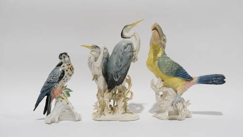
A lot of three porcelain bird figurines by Karl EnsOstantix Auctions4.4(10)See Sold PriceFeb 28, 2024
Ampol Three Wheeled Car with Spinning Map Parasol - Tin ToyThe RSL Auction Company4.6(239)See Sold PriceMar 09, 2024
1977 JRR Tolkien 1st ed Silmarillion Lord of the Rings Middle Earth + MAPSchilb Antiquarian Rare Books4.8(421)See Sold PriceMar 31, 2024
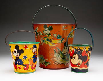
THREE TIN LITHOGRAPH DISNEY MICKEY MOUSE PAILS.Amelia Jeffers, Auctioneers & Appraisers4.6(101)See Sold PriceMar 08, 2024
1849 Orr & Co. Hand Colored Southern Germany MapMatthew Bullock Auctioneers4.7(1.8k)See Sold PriceMar 02, 2024
1675: ANTIQUE ILLUSTRATED JULIUS CAESAR MAPS OF ROMAN HISTORYNY Elizabeth 4.3(84)See Sold PriceMar 03, 2024
Set of 4 Maps - Netherlands - Seven United Provinces - Germany - Sweden, Denmark, Norway, FinlandProverde Auctions4.3(3)See Sold PriceFeb 28, 2024


![[JUGGLERS]. Sixteen Variety Broadsides Featuring European J... (1 of 1)](https://p1.liveauctioneers.com/928/317913/170626297_1_x.jpg?height=282&quality=70&version=1706650066)