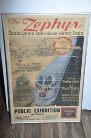
Chicago Burlington and Quincy RR 1934 Streamlined Zephyr Motor Train PosterJM Hobby Supply and Railroad Artifact Auctions4.4(127)See Sold PriceFeb 24, 2024
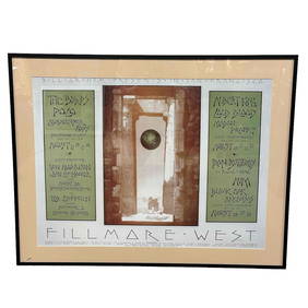
Vintage Led Zeppelin, The Byrds and Many others 1970 Bill Graham Concert PosterPremier Auction Galleries4.3(331)See Sold PriceMar 09, 2024
DRINK BIG CHIEF SODA WATER EMBOSSED TIN SIGN W/ NATIVE AMERICAN GRAPHIC.Dan Morphy Auctions4.2(1.3k)See Sold PriceFeb 24, 2024
POLLY GAS PORCELAIN NEON SIGN W/ ORIGINAL METAL CAN.Dan Morphy Auctions4.2(1.3k)See Sold PriceFeb 24, 2024
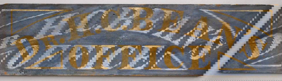
"OPEN 4:30 COCKTAILS" TWO-SIDED TRADE SIGNJohn McInnis Auctioneers,LLC4.5(505)See Sold PriceFeb 25, 2024
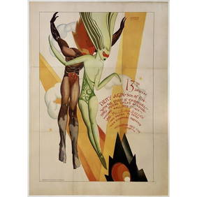
Original Vintage Poster 13th DESCENT KOKOON ARTS CLUB '26 Cleveland Carnival OLActivity Auctions4.5(357)See Sold PriceFeb 27, 2024
SoldEphemera Highway Maps - 7 maps(3) Conoco (Iowa, Nebraska, Chicago), (2) Diamond Road Maps (Kansas, Michigan), (1) Tydol Gasoline (Massachusetts, Rhode Island, Connecticut) (1) Texaco (North Dakota) All Folded MapsSee Sold Price
Alaska Ephemera Lot #7: Map of Alaska, 1900Alaska Ephemera Lot #7: Map of Alaska, 1900. 14" x 11", color.See Sold Price
SoldEphemera Highway Maps and Fishing Information -(1) Pure Oil Company (1) Phillips 66, (1) 1946 Texaco, and (3) location maps for travel, fishing and sports, (1) 1940 Minnesota Arrowhead Country, (1) 1930, 190 Pages Minnesota Book - Land of PleasureSee Sold Price
SoldEphemera Highway Maps Lot of 55 Highway Maps 1940 Colorado, 1941 Montana and Wyoming, 1930's Mobil gas (Iowa), Standard Oil Co., Places To Go by John P Roberts - 50 pagesSee Sold Price
SoldProspectus for "Phoenix Gold Mining Co." Black Hills8" x 12" Booklet - Illustrated with photos & maps. 7" x 16" FO Claim map.Date: 1903Country if not USA: State: DakotasCity: DeadwoodProvenance:See Sold Price
SoldEphemera Standard Oil Highway Vintage Maps- 5Standard Oil Highway Maps- Compliments of Standard Oil Company Indiana (Michigan, Missouri, Kansas, Colorado, Iowa).See Sold Price
SoldWWII US / Chinese Military EphemeraComprising: four maps, Chinese Ministry of Information "War Map of China and Far East Showing Japanese Military Aggression (July 7, 1943)", MacMillan "Map of China (1937-1943)", "Follow the War: HagstSee Sold Price
Sold19th C Linen Manuscript Map Tuckingmill Cornwall19th century manuscript linen map on an area referred to as Tuckingmill in the County of Cornwall. Very Good, Measures 9 x 7”. Please note that this lot has a confidential reserve. When you leave aSee Sold Price
SoldJigsaw maps,7 maps + guides in box,Paris,1825Jigsaw maps.- 7 engraved maps of the World, Europe, Africa, Asia, North America, South America and France, hand-coloured in outline, world map with hand-coloured allegorical vignettes of theSee Sold Price
Sold12 maps of northeastern states. Asher & Adams, et[United States: Mid-Atlantic]. 12 Maps. ++ 7 maps: Asher & Adams' (1) Pennsylvania And New Jersey, (2) New York And Part Of Ontario, (3) New Hampshre, Vermont, Massachusetts, Rhode Island, And ConnectSee Sold Price
SoldVirginia & Truckee Railroad Maps, Business Archive andLot of 3. 1) Virginia Truckee Railway Monthly Statement of Account (2). From 1900's. 2) Virginia & Truckee Railway Form 71 (2). 3) Virginia and Truckee Railroad maps (7). Maps show Reno to Minden withSee Sold Price
SoldGrp: 7 Maps of Sicily and Sardinia ItalyGroup of seven maps of Sicily and Sardinia, Italy. Early 18th century Johann Homann (1664-1724) map "Regnorum Sicilia et Sardinia;" 18th century Homann Heirs map of Sicily "Regni & Insulae Siciliae TaSee Sold Price
SoldGrp: 7 Maps of Sicily Italy 18th/19th c. Blair ClGroup of seven maps of Sicily. Includes Rev. John Blair, "Sicilia Antiqua quae at Sicania et Trinacria dicta;" Philipp Cluver, "Siciliae Antiquae Descriptio," Leiden, 1697, which features a stunninglySee Sold Price
SoldGrp: 7 Maps of Russia and EuropeGroup of seven maps of Russia and Europe. Includes a map of the Kamchatka Peninsula "Carte Du Kamtchatka Dressee et Gravee par Laurent." A map of the lands inhabited by the Sami and Khanty peoples "CaSee Sold Price
Sold7 Maps incl North America and PanamaIncludes Panama to Guayaquil (Thomas Kitchin), Mexico & Gautemala (Thomas Coperthwait & Co., 1850), Utah & Nevada (Mitchell), California (Mitchell, 1874), State of Texas (Mitchell, 1852), North AmericSee Sold Price
SoldGrp: 7 Maps of Italian Cities and a Map of BrusseGroup of eight 18th century maps, comprised of seven maps of Italian cities and one map of Brussels. The maps of Italian cities include: Ancona, Trieste, Modena, Genoa, and Padua. SKU: 03511See Sold Price
SoldGrp: 7 Maps of South AmericaGroup of seven maps of South America. Includes three maps of the continent overall; one map of North and South America; two maps of southern South America, depicting Chile, Argentina, Uruguay, and BolSee Sold Price
SoldM371-M377 Grp: 7 Maps of South AmericaGroup of seven maps of South America. Includes one hand colored map, "A Chart of the Streights of Magellan;" one 18th century map of Guyana by R. Waddington, "A Chart of the Coast of Guayana, From theSee Sold Price
SoldGrp: 7 Maps of IndiaGroup of seven maps of India. Includes two hand colored maps by Pierre Duval (1618-1683), "Presquisle de L'Inde de ca le Gange" and "Empire Du Mogol"; three maps by Girolamo Ruscelli (1500-1566), "TabSee Sold Price
SoldMaps C1850-1908 Mixed Lot of 7 MapsMixed Lot of Engraved and Lithographed Maps. Incl German Empire, Europe, Canaan/Palestine, Central Europe, Zoological Regions of the World and British Isles. Examples by Stanford/Medland, Weller, GoldSee Sold Price
SoldBlackie & Weller 1882 Lot 7 Maps of South America etcIncl South America, Venezuela/Colombia, Brazil, Peru/Bolivia, and Argentina/Chile. Also North Atlantic and Pacific Ocean. Lithograph Maps Published 1882 by Blackie & Son, London for "The ComprehensiveSee Sold Price
SoldBartholomew, John 1922 Lot 7 Maps. Baltic, Germany etcIncl Germany West, Germany East, Southern Scandinavia/Denmark, Poland/Czecho-Slovakia, Siberia, Northern Russia/Finland, Baltic States/East Prussia. Large Lithograph Maps Published 1922 by The Times,See Sold Price
SoldPhilip, George C1900 Lot of 7 Maps of UK & IrelandLithograph Maps Published C1900, London for "Philips' New Handy General Atlas of the World" by George Philip. Paper Size: 14.5 x 10.5 inch (37 x 27cm) Good ConditionSee Sold Price
EARLY 18TH C. DUTCH CHART OF PACIFIC OCEAN BY FREDERIK DE WIT (1629-1706) WITH CALIFORNIA AS ANThomaston Place Auction Galleries4.4(393)See Sold PriceFeb 24, 2024
DUNLEVIE c1856 Map Counties Of Gaspe & Bonaventure Quebec Canada SCARCE! #2Luis Porretta Fine Arts4.3(10)See Sold PriceMar 02, 2024
DEVINE c1856 Dr Salters Map Of Lake Huron Ontario Indian Lands etc. No. 7 ScarceLuis Porretta Fine Arts4.3(10)See Sold PriceMar 02, 2024
Vintage 1955 German Leather Map CaseThe Benefit Shop Foundation Inc.4.3(2.9k)See Sold PriceFeb 28, 2024
[WORLD WAR II – OKINAWA]. Okinawa Shima Western Beaches Top...Potter & Potter Auctions4.6(545)See Sold PriceMar 07, 2024
[CHICAGO]. Rare Pre-Fire Illinois Map: “Blanchard’s Map of ...Potter & Potter Auctions4.6(545)See Sold PriceMar 07, 2024
1704 DESCRIPTION OF ALL THE SEATS OF THE PRESENT WARS OF EUROPE antique w/ MAPSJasper524.5(9.9k)See Sold PriceFeb 27, 2024
MAGHREB. North Africa Morocco Algeria & Tunisia. JOHNSTON 1913 old antique mapJasper524.5(9.9k)See Sold PriceFeb 28, 2024
VERTICAL AXIS OF WU GUANZHONG'S LANDSCAPE MAPMega International Auction4.3(62)See Sold PriceMar 23, 2024
Lot Of Mid Century Ephemera, Including Maps & 1957 License PlatesClark's Auction Company4.6(443)See Sold PriceMar 03, 2024
Vintage 1920s Rand McNally Auto Trails MapThe Benefit Shop Foundation Inc.4.3(2.9k)See Sold PriceMar 20, 2024


![[WORLD WAR II – OKINAWA]. Okinawa Shima Western Beaches Top... (1 of 1)](https://p1.liveauctioneers.com/928/318880/171361141_1_x.jpg?height=282&quality=70&version=1707501302)
![[CHICAGO]. Rare Pre-Fire Illinois Map: “Blanchard’s Map of ... (1 of 2)](https://p1.liveauctioneers.com/928/318880/171361260_1_x.jpg?height=282&quality=70&version=1707501302)


