Vintage Ca. 1940's International Panel Delivery Truck Converted into Stationary Food Truck, WasSwisher Bros. Auction LLC4.4(257)See Sold PriceFeb 25, 2024
Martin Custom Acoustic Guitar 000 Body Style Rosewood with Hard CaseHess Fine Auctions4.5(213)See Sold PriceMar 02, 2024
1968 Gibson LG-0 Acoustic Dreadnought Parlor GuitarHess Fine Auctions4.5(213)See Sold PriceMar 02, 2024
Replica Robinson 1862 Sharps CarbineSchmidt's Antiques Inc. Since 19114.8(440)See Sold PriceMar 02, 2024
PAIR (18th c) OF FLINTLOCK DUELING PISTOLSJohn McInnis Auctioneers,LLC4.5(505)See Sold PriceFeb 24, 2024
PAIR T KETLAND of LONDON .60 CAL FLINTLOCK PISTOLSJohn McInnis Auctioneers,LLC4.5(505)See Sold PriceFeb 25, 2024
Gibson ES335 Semi Hollow Vintage Sunburst Electric Guitar with Certificate of Authenticity Hand MadeHess Fine Auctions4.5(213)See Sold PriceMar 02, 2024
WALT DISNEY WORLD - Figment Animatronic Character Skin from EPCOT's Journey Into ImaginationPropstore4.3(7)See Sold PriceMar 12, 2024
Lot Of 3 Early Large Three-Ring Binders Full Of Thousands Of StampsRbfinearts4.5(579)See Sold PriceFeb 24, 2024
A FINE PERSIAN MALAYER PRAYER RUG WITH CYPRESS C. 1860Soulis Auctions4.8(958)See Sold PriceFeb 24, 2024
Thomas Hart Benton; 20thC. American Regionalist Oil SignedMid-Hudson Auction Galleries4.4(471)See Sold PriceFeb 24, 2024
Fender USA Stratocaster Electric Guitar Classic Candy Red and White Original Stickers with Gig BagHess Fine Auctions4.5(213)See Sold PriceMar 02, 2024
1986 Fender Stratocaster Japan Blue-Green with White Pickguard and Gig Bag JapaneseHess Fine Auctions4.5(213)See Sold PriceMar 02, 2024
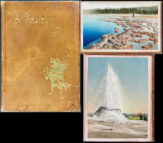
SoldEnsign & Thayer's Western Map Book 1851 w/ Pa MapEnsign & Thayer's Map of the Western United States. Cover 5-1/2" x 3-1/2", brown leather/gilt with locomotive and riverboat. Cover page "Ensign & Thayer's Travellers Guide Through the States of Ohio,See Sold Price
SoldWith State Seals /Presidents Surrounding U.S. MapAtwood, J. M. (1818-c. 1880) & Phelps, Humphrey (fl. c. 1830-1860). Phelps's National Map of the United States, a Travellers Guide... Engraved map. Ensign & Thayer, 1851. 20 ½" x 25 ¾" sheet. "ESee Sold Price
With State Seals /Presidents Surrounding U.S. MapAtwood, J. M. (1818-c. 1880) & Phelps, Humphrey (fl. c. 1830-1860). Phelps's National Map of the United States, a Travellers Guide... Engraved map. Ensign & Thayer, 1851. 20 ½" x 25 ¾" sheet. "ESee Sold Price
SoldENSIGN & THAYER’S MAP OF THE WESTERN STATES. 1854.[United States/Midwest]. ENSIGN & THAYER’S MAP OF THE WESTERN STATES [Cover title]. Pocket map, with printed text. Map of the Western States by J. M. Atwood. 1854. 21 ½ x 27 inches (sheet size unfoSee Sold Price
Sold1849 Map of the Western States Ensign Thayer.1849 Map of the Western States Ensign Thayer. Ensign & Thayer's Map of the Western States. Pocket Map. 1849. 21 x 27". Hand-colored. Some tears and separations at folds. Complete. Includes west to NebSee Sold Price
SoldENSIGN & THAYER MAP OF THE WESTERN STATESENSIGN & THAYER, MAP OF THE WESTERN STATES, 19TH CENTURY:Ensigns & Thayer's Traveler's Guide through the States of Ohio, Michigan, Indiana, Illinois, Missouri, Iowa, and Wisconsin; with Railroad, CanaSee Sold Price
SoldBreou's Chester County, PA Map BookBreou's Chester County, PA Map Book - 1883, Compiled, Drawn and Published from Personal Examinations and Surveys by W.H. Kirk & Co. Philadelphia. CONDITION: 1 Map page loose, cover worn especially onSee Sold Price
Sold[MAP]. ENSIGN & THAYER. Ornamental Map of the US.. 1848287. [MAP]. ENSIGN & THAYER (publishers). Map with pictorial broadside, all enclosed within a green border of stars and chains and red U.S. shields at each corner: [Title of broadside at top]: OrnSee Sold Price
Sold[MAP]. ENSIGN & THAYER. Seat of War & Battles. 1847.288. [MAP]. ENSIGN & THAYER (publishers). Map with pictorial broadside: [Title of broadside at top]: Seat of War & Battles; [title of map]: Map of the Seat of War; [below lower border of broadSee Sold Price
SoldWestern Americana Expedition Map BookThomas W. Symons. Report of an Examination of the Upper Columbia River. 1881. Book with maps. 11 1/4" x 8".See Sold Price
SoldMap of Pa & Rules of the Road Book1931 J Harvey Spahr Manheim, Pa. Motor Patrol Road Rules & Map of PA. W Litzenberger Manheim, PA. 8" t. & 5 ½" t. (Good, Minor Fading, Cover Detached);See Sold Price
SoldEastern & Western Hemisphere Maps w/ Animal ScenesEnglish, mid 19th century. Two hand colored steel engraved maps comprising of a Western Hemisphere & Eastern Hemisphere from "The World in Two Hemispheres" (1851) within a single frame, with illustratSee Sold Price
Ornamental Map of the United States & Mexico.Very Popular Map & Broadside Expressing Extreme Patriotism 293. [MAP]. ENSIGN & THAYER (publishers). [At top] OrSee Sold Price
1569 MUNSTER COSMOGRAPHY LEAF w/ MAP of WESTERN FLANDERS antique 16th century1 leaf w/ woodcuts, from S. MUNSTER, Cosmographey (...) (Basel, 1569). With map of Western Flanders. Double sided. With padding. Size 7 1/2 by 11 3/4 Pad 9 3/4 by 13 3/4" Text in German Very good condSee Sold Price
1569 MUNSTER COSMOGRAPHY LEAF w/ MAP of WESTERN FLANDERS antique 16th century1 leaf w/ woodcuts, from S. MUNSTER, Cosmographey (...) (Basel, 1569). With map of Western Flanders. Double sided. With padding. Size 7 1/2 by 11 3/4 Pad 9 3/4 by 13 3/4" Text in German Very good condSee Sold Price
1569 MUNSTER COSMOGRAPHY LEAF w/ MAP of WESTERN FLANDERS antique 16th century1 leaf w/ woodcuts, from S. MUNSTER, Cosmographey (...) (Basel, 1569). With map of Western Flanders. Double sided. With padding. Size 7 1/2 by 11 3/4 Pad 9 3/4 by 13 3/4" Text in German Very good condSee Sold Price
1569 MUNSTER COSMOGRAPHY LEAF w/ MAP of WESTERN FLANDERS antique 16th century1 leaf w/ woodcuts, from S. MUNSTER, Cosmographey (...) (Basel, 1569). With map of Western Flanders. Double sided. With padding. Size 7 1/2 by 11 3/4 Pad 9 3/4 by 13 3/4" Text in German Very good condSee Sold Price
1632 EUROPE DESCRIPTION by MERCURII GALLOBEGICI antique VELLUM BOUND w/ MAPMERCURII GALLOBEGICI sive, rerum in Gallia et Belgio potissimum; Hispania quoqve Italia, Anglia, Germania, Ungaria, Bohemia... Frankfurt; 1632 Illustrated with one plate and the map of Western EuropeSee Sold Price
1569 MUNSTER COSMOGRAPHY LEAF w/ MAP of WESTERN FLANDERS antique 16th century1 leaf w/ woodcuts, from S. MUNSTER, Cosmographey (...) (Basel, 1569). With map of Western Flanders. Double sided. With padding. Size 7 1/2 by 11 3/4 Pad 9 3/4 by 13 3/4" Text in German Very good condSee Sold Price
1569 MUNSTER COSMOGRAPHY LEAF w/ MAP of WESTERN FLANDERS antique 16th century1 leaf w/ woodcuts, from S. MUNSTER, Cosmographey (...) (Basel, 1569). With map of Western Flanders. Double sided. With padding. Size 7 1/2 by 11 3/4 Pad 9 3/4 by 13 3/4" Text in German Very good condSee Sold Price
[PRINT]. ENSIGNS. Ornamental Map.... 1848[PRINT]. ENSIGNS & THAYER (publishers). Ornamental Map of the United States & Mexico. [along bottom] Bowle and Ward, 43 Cornhill, Boston. Entered According to Act of Congress in the Year 1848,See Sold Price
[PRINT]. PHELPS. Ornamental Map.... 1847[PRINT]. PHELPS, ENSIGNS & THAYER (publishers). Ornamental Map of the United States & Mexico. 1847. [Along bottom]: Entered According to Act of Congress in the Year 1846, by Humphrey Phelps, iSee Sold Price
Sold2 Manuscript maps2 Manuscript maps- Western PA & United States, fair condition. 30 x 21''; 19 x 16 1/2''See Sold Price
Sold1849 guide to Western States w/ gold rush mapHeading: (California Gold Rush) Author: Steele, Oliver G. Title: Steele’s Western Guide Book, and Emigrant’s Directory; Containing Different Routes Through the States of New York, Ohio, Indiana, ISee Sold Price
Crams Township and Railroad Map of Pennsylvania-1898JM Hobby Supply and Railroad Artifact Auctions4.4(127)See Sold PriceFeb 24, 2024
1885 CIVIL WAR 1ed Famous Memoirs US Grant Sheridan Sherman 6v RARE LOT MapsSchilb Antiquarian Rare Books4.8(431)See Sold PriceMar 10, 2024
Vintage County Map Of NY State Plate EngravingThe Benefit Shop Foundation Inc.4.3(3k)See Sold PriceFeb 28, 2024
Large lot of assorted prints. 18th-20th century. To include: North American and other maps, CivilTremont Auctions4.5(298)See Sold PriceFeb 25, 2024
Pair of Early Railroad Maps - 1874 Delaware, Lackawanna & Western and 1876 Pennsylvania RailroadRail & Road Auctions4.6(165)See Sold PriceMar 07, 2024
Rand McNally Railroad Map Cabinet w/ 21 Railroad MapsRail & Road Auctions4.6(165)See Sold PriceMar 08, 2024
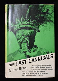
THE LAST CANNIBALS by JENS BJERRE 1957 Fine or Near FineNorth American Artifact Auctions4.7(201)See Sold PriceApr 20, 2024
[WORLD WAR II – OKINAWA]. Okinawa Shima Western Beaches Top...Potter & Potter Auctions4.6(550)See Sold PriceMar 07, 2024
Willem Blaeu, Etc. 17th C. Antiquarian Maps, 2Auctions at Showplace4.6(744)See Sold PriceMar 17, 2024
D'Oyly (Calcutta, India) - Government House from St. Andrew's LibraryTrillium Antique Prints & Rare Books4.5(33)See Sold PriceFeb 24, 2024
D'Oyly (Calcutta, India) - Procession of the CurruckpoojaTrillium Antique Prints & Rare Books4.5(33)See Sold PriceFeb 24, 2024
Putnam - First Map of the State of Ohio by Rufus PutnamTrillium Antique Prints & Rare Books4.5(33)See Sold PriceFeb 24, 2024
Schmidt's Memoir, A Western Trip - Volume with 12 Photos by William Henry Jackson, 17 by Schmidt andTrillium Antique Prints & Rare Books4.5(33)See Sold PriceFeb 24, 2024
De Jode, Rare, pub. 1593 - Map of Africa (Africae Vera Forma, et Situs)Trillium Antique Prints & Rare Books4.5(33)See Sold PriceFeb 24, 2024
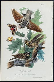
Audubon - Common Osprey Fish Hawk. 15Trillium Antique Prints & Rare Books4.5(33)See Sold PriceFeb 24, 2024
Audubon, Imperial Folio - American Cross Fox. 6Trillium Antique Prints & Rare Books4.5(33)See Sold PriceFeb 24, 2024
Audubon, Imperial Folio - Canada Lynx. 16Trillium Antique Prints & Rare Books4.5(33)See Sold PriceFeb 24, 2024
1738 BIBLE in DUTCH ILLUSTRATED w/ MAPS MASSIVE FOLIO in DUTCH antique BIBLIAJasper524.5(9.9k)See Sold PriceFeb 27, 2024


![[MAP]. ENSIGN & THAYER. Ornamental Map of the US.. 1848 (1 of 4)](https://p1.liveauctioneers.com/514/38480/16487178_1_x.jpg?height=282&quality=70&version=1363614971)
![[MAP]. ENSIGN & THAYER. Seat of War & Battles. 1847. (1 of 6)](https://p1.liveauctioneers.com/514/38480/16487180_1_x.jpg?height=282&quality=70&version=1363614971)


![[PRINT]. ENSIGNS. Ornamental Map.... 1848 (1 of 3)](https://p1.liveauctioneers.com/514/95456/48680539_1_x.jpg?height=282&quality=70&version=1477936169)
![[PRINT]. PHELPS. Ornamental Map.... 1847 (1 of 4)](https://p1.liveauctioneers.com/514/95456/48680540_1_x.jpg?height=282&quality=70&version=1477936169)


![[WORLD WAR II – OKINAWA]. Okinawa Shima Western Beaches Top... (1 of 1)](https://p1.liveauctioneers.com/928/318880/171361141_1_x.jpg?height=282&quality=70&version=1707501302)