17TH C. ENGLISH LINEAR MAP BY OGILBY, FRAMEDThomaston Place Auction Galleries4.4(389)See Sold PriceFeb 24, 2024
MAP - PIETER SCHENK / VALK / JANSSEN Hand Colored superb Map Central Italy c1702Luis Porretta Fine Arts4.3(10)See Sold PriceMar 02, 2024
OGILVY & BOWEN c1736 Original Map of Oxfordshire Berkshire Etc.Luis Porretta Fine Arts4.3(10)See Sold PriceMar 02, 2024
CHARLES ROLLIN c1828 Ceasar Hand Colored Africa Military MapLuis Porretta Fine Arts4.3(10)See Sold PriceMar 02, 2024
MAP - Dufour, A. H. ( Malte / Brun ) :MAP - ESPAGNE PARTIE SUD DIVISEE EN PROVINCES ANCIENNES ( MAPLuis Porretta Fine Arts4.3(10)See Sold PriceMar 02, 2024
RIGOBERT BONNE c1787 Original Colored Map Germany & Region 15" x 12"Luis Porretta Fine Arts4.3(10)See Sold PriceMar 02, 2024
AMBROISE TARDIEU c1822 Napoleonic War Map GermanyLuis Porretta Fine Arts4.3(10)See Sold PriceMar 02, 2024
MAP - AMBROISE TARDIEU c1822 Napoleonic Miltary Map GermanyLuis Porretta Fine Arts4.3(10)See Sold PriceMar 02, 2024
1822 Rare Map by Ambroise Tardieu Napoleon Caldiero Battle of Vento 17" x 11Luis Porretta Fine Arts4.3(10)See Sold PriceMar 02, 2024
THOMAS MOULE 1837 Colored Map of Warwickshire Framed vgcLuis Porretta Fine Arts4.3(10)See Sold PriceMar 02, 2024
PIETER SCHENK / VALK / JANSSEN Hand Colored Map of Rhodes Greece ca1702 vgcLuis Porretta Fine Arts4.3(10)See Sold PriceMar 02, 2024
STICH & DRUCK c1888 Map Austrian Alps 20" x 16"Luis Porretta Fine Arts4.3(10)See Sold PriceMar 02, 2024
SoldMap of Empire of Charlemagne. Europe. 1854.Print of hand colored steel engraving titled „Carte du Partage de L’Empire de Charlemagne“.Drawn by L. Dussieux.Engraved by unknown.From „Atlas General De Geographie physique, politique et hisSee Sold Price
Empire of Charlemagne. Europe. 1854.Print of hand colored steel engraving titled „Empire de Charlemagne“.Drawn by L. Dussieux.Engraved by unknown.From „Atlas General De Geographie physique, politique et historique par L. Dussieux.See Sold Price
SoldMap of Roman Empire. Europe. 1854.Print of hand colored steel engraving titled „Carte de L’Empire Romain”.Drawn by L. Dussieux. Engraved by unknown.From „Atlas General De Geographie physique, politique et historique par L. DusSee Sold Price
EMPIRE OF CHARLEMAGNE. 'Europe in the beginning of the 9th Century' 1876 mapCAPTION PRINTED BELOW PICTURE: 'Europe in the beginning of the 9th Century Shewing the Empire of Charlemagne' DATE PRINTED: 1876 IMAGE SIZE: Approx 16.0 x 22.5cm, 6.25 x 8.75 inches (Medium) TYPE: AntSee Sold Price
Map of Empire Of Alexander. Europe. 1854.Print of hand colored steel engraving titled „Empire D’Alexandre”.Drawn by L. Dussieux. Engraved by unknown.From „Atlas General De Geographie physique, politique et historique par L. Dussieux.See Sold Price
Map of French Empire in 1813. Europe. 1854.Print of hand colored steel engraving titled „Carte de L’ Empire Francais en 1813”.Drawn by L. Dussieux. Engraved by Marlier.From „Atlas General De Geographie physique, politique et historiqueSee Sold Price
Imperium Caroli Magni… Empire of Charlemagne. Western Europe VAUGONDY 1752 mapTITLE/CONTENT OF MAP: 'Baltic Sea' DATE PRINTED: 1860 IMAGE SIZE: Approx 35.5 x 27.0cm, 14 x 10.5 inches (Large); Please note that this is a folding map. TYPE: Antique steel engraved map with originalSee Sold Price
Map of Empire of Germany. Europe. 1854.Print of hand colored steel engraving titled „De l’Empire D’Allemagne“.Drawn by L. Dussieux.Engraved by unknown.From „Atlas General De Geographie physique, politique et historique par L. DusSee Sold Price
Map of Empire of Germany. Europe. 1854.Print of hand colored steel engraving titled „Carte pour servir a l’Histoire de L’Empire D’Allemagne“.Drawn by L. Dussieux.Engraved by unknown.From „Atlas General De Geographie physique, pSee Sold Price
Imperium Caroli Magni… Empire of Charlemagne. Western Europe VAUGONDY 1752 mapTITLE OF MAP (NOT PRINTED ON THE PAGE):'Imperium Caroli Magni Occidentis Imperatoris complectens Galliam, Marcam Hispanicam, Baleares insulas Corsicam Italiam Valturnum usque et Aufidum fluv? InstriamSee Sold Price
Imperium Caroli Magni… Empire of Charlemagne. Western Europe VAUGONDY 1752 mapTITLE OF MAP (NOT PRINTED ON THE PAGE):'Imperium Caroli Magni Occidentis Imperatoris complectens Galliam, Marcam Hispanicam, Baleares insulas Corsicam Italiam Valturnum usque et Aufidum fluv? InstriamSee Sold Price
Map of the Empire of Germany. Europe. 1854.Print of hand colored steel engraving titled „Carte Geographique de L’ Empire D’ Allemagne”.Drawn by L. Dussieux.Engraved by unknown.From „Atlas General De Geographie physique, politique etSee Sold Price
SoldDelamarche, Felix 1829 Lot of 3 Maps. Europe & Germany"L'Europe a l'Epoque du demembrement de l'Empire de Charlemagne" "L'Europe avan l'Invasion des Barbares" and "Germania Antiqua et regiones Danubium" Copper Engraved Maps Published 1829, Paris for "AtlSee Sold Price
SoldDelamarche, Felix 1829 Pair of Maps. Europe Charlemagne"L'Europe a l'Epoque du demembrement de l'Empire de Charlemagne" and "L'Europe divisee en ses differens Etats sous Charlemagne" Copper Engraved Maps Published 1829, Paris for "Atlas de La Geographie..See Sold Price
Map of Europe. Empire of Charlemagne. 1828.Print of steel engraving titled L‘Europe du demembrement de Empire de Charlemagne“.Author Fellx Delamarche.Engraved by unknown.From Atlas de la Geographie ancienne du moyen age et moderne“ by FeSee Sold Price
Maps C1875 Lot of 8 From the National EncyclopediaIncl Plymouth Sound, Manchester Ship Canal, Charlemagne Empire, Carlovingian Empire, Europe, England and Wales, Suez Canal, and Ancient Britain. Lithograph Maps Published C1868-81 by William MackenzieSee Sold Price
Maps C1875 Lot of 8 From the National EncyclopediaIncl Plymouth Sound, Manchester Ship Canal, Charlemagne Empire, Carlovingian Empire, Europe, England and Wales, Suez Canal, and Ancient Britain. Lithograph Maps Published C1868-81 by William MackenzieSee Sold Price
Imperium Caroli Magni Occidentis ImperatorisTITLE/CONTENT OF MAP: 'Imperium Caroli Magni Occidentis Imperatoris' The Empire of Charlemagne. Carolingian Empire. Western Europe DATE PRINTED: Published in 1785. Engraved in 1785 (this date is printSee Sold Price
"Imperium Caroli Magni Occidentis Imperatoris"TITLE/CONTENT OF MAP: 'Imperium Caroli Magni Occidentis Imperatoris' The Empire of Charlemagne. Carolingian Empire. Western Europe DATE PRINTED: Published in 1785. Engraved in 1785 (this date is printSee Sold Price
SoldImperium Caroli Magni. [1600's].[Europe]. Imperium Caroli Magni. Depicts Europe at the height of Charlemagne’s empire. In image at lower right: “Amstelodami sumptibus Henrici Hondy.” [1600’s]. 14 ½” x 20 5/8”. French teSee Sold Price
1757 Imperium Caroli Magni Occidentis Imperatoris…By: Robert De Vaugondy Date: 1757 (Published) Paris Dimensions: 18.75 x 21.5 inches (47.6 cm x 54.6 cm) This is an authentic, antique map of Western Europe during the time of Charlemagne's empire by RSee Sold Price
ADRIEN HUBERT BRUE - L'EUROPE SOUS L'EMPIRE DEAdrien Hubert Brue - L'europe Sous L'empire De Charlemagne, 1826 - 40 X 29 1/8 In. - This Giclée Print Is Gallery Stretched And Ready To Hang Or Lean Against A Wall, Or Display On An Easel. - A Gicl�See Sold Price
ADRIEN HUBERT BRUE - L'EUROPE SOUS L'EMPIRE DE CHAdrien Hubert Brue - L'Europe Sous L'Empire De Charlemagne, 1826 - Giclée On Canvas - 44 X 32 In. A Giclée Print Is The Highest Quality Print Available Today. Because There Is No Visible Dot ScreenSee Sold Price
L'EUROPE SOUS L'EMPIRE DE CHARLEMAGNE, 1826…ADRIENAdrien Hubert Brue - L'europe Sous L'empire De Charlemagne, 1826 - 40 X 29 1/8 In. - This Giclée On Canvas Is Gallery Stretched And Ready To HangSee Sold Price
Numismatic Books - Humphreys - The Coinage of the British EmpireTimeLine Auctions Ltd.4.6(182)See Sold PriceMar 09, 2024
1835 Revolutions in Europe Charlemagne Crusades Columbus Voyages Ottoman WaterlooSchilb Antiquarian Rare Books4.8(422)See Sold PriceMar 31, 2024
ATTR TO LIBERTY COMPANY ARTS CRAFTS COPPER MIRRORAntique Arena Inc.4.5(866)See Sold PriceFeb 24, 2024
ARTS AND CRAFTS HAMMERED LAMP BY FREDRICK FIFIELDAntique Arena Inc.4.5(866)See Sold PriceFeb 24, 2024
MEDIEVAL EUROPEAN CONVERT’S CROSS NECKLACE, 9th-10th CENTURYJasper524.5(9.8k)See Sold PriceFeb 28, 2024
NORTHERN EUROPEAN CONVERT’S CROSS NECKLACE, 9th-10th CENTURYJasper524.5(9.8k)See Sold PriceFeb 28, 2024
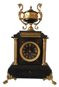
TABLE CLOCK: EMPIRE III STYLE IN CARVED BLACK MARBLE AND GOLDEN BRONZE - FRANCE XIX CENTURYABC Gallery4.2(8)See Sold PriceMar 18, 2024
BALE CHRISTIAN: (1974- )International Autograph Auctions Europe S.L.4.5(52)See Sold PriceMar 12, 2024
SHARIF OMAR: (1932-2015)International Autograph Auctions Europe S.L.4.5(52)See Sold PriceMar 12, 2024
CUSHING PETER: (1913-1994)International Autograph Auctions Europe S.L.4.5(52)See Sold PriceMar 13, 2024
NAZARIANTZ HRAND: (1886-1962)International Autograph Auctions Europe S.L.4.5(52)See Sold PriceMar 14, 2024
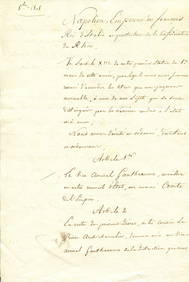
PONIATOWSKI JOZEF: (1763-1813)International Autograph Auctions Europe S.L.4.5(52)See Sold PriceMar 14, 2024
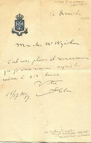
MARIE LOUISE DUCHESS OF PARMA: (1791-1847)International Autograph Auctions Europe S.L.4.5(52)See Sold PriceMar 14, 2024
DULEEP SINGH VICTOR: (1866-1918)International Autograph Auctions Europe S.L.4.5(52)See Sold PriceMar 14, 2024
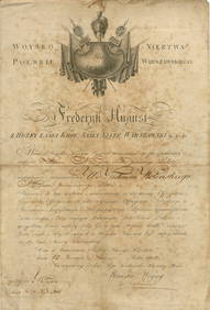
DULEEP SINGH FREDERICK: (1868-1926)International Autograph Auctions Europe S.L.4.5(52)See Sold PriceMar 14, 2024
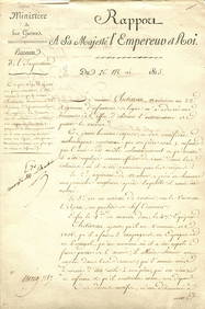
KUTUZOV MIKHAIL: (1745-1813)International Autograph Auctions Europe S.L.4.5(52)See Sold PriceMar 14, 2024


![Imperium Caroli Magni. [1600's]. (1 of 1)](https://p1.liveauctioneers.com/179/31966/12805909_1_x.jpg?height=282&quality=70&version=1346557511)


![[TOKYO TRIAL]: (1 of 20)](https://p1.liveauctioneers.com/1458/320148/172030880_1_x.jpg?height=282&quality=70&version=1708367366)