SoldEldridge chart North America Coast 1882Antique Cape Henry to Cape Sable canvas back chart by Eldrige, as is condition - tears and creasesSee Sold Price
SoldELDRIDGE CHART OF THE EAST COAST OF NORTH AMERICAOcean chart of the east coast of North America from Cape Henry to Halifax. This is an Eldridge chart K, drawn in 1918 and stamped 1920. Compiled from surveys of the United States government. The BritiSee Sold Price
1886 Eldridge chart of North AmericaOriginal chart titled “Coast of North America from Cape Henry to Cape Sable including Chesapeake and Delaware Bays from the U.S. Coast Admiralty’s and George Eldridge Surveys”. The chart carriesSee Sold Price
SoldHand Colored North America ChartHand colored copy from an original 1876 Eldridge's chart showing the upper east coast of North America from New Jersey to New Brunswick Canada and an inset panel showing the Chesapeake Bay. Framed.See Sold Price
1884 Eldridge Chart of North AmericaOriginal chart of North America detailin Chesapeake Bay from 1884. Condition: with losses. Dimensions: 50" L x 47" H Weight: 9.5lbs *This lot is part of a maritime antique auction of ship models, nautSee Sold Price
SoldA MAP, NORTH AMERICA, 1825,A MAP, NORTH AMERICA, 1825, outline chart of North America detailing the West Coast and Gulf of Mexico showing approved route across the Pacific. Some soundings in Gulf. Perhaps printed in Spain copieSee Sold Price
A MAP, NORTH AMERICA, 1825, outline chart of North AmerA MAP, NORTH AMERICA, 1825, outline chart of North America detailing the West Coast and Gulf of Mexico showing approved route across the Pacific. Some soundings in Gulf. Perhaps printed in Spain copieSee Sold Price
Southern California Bight islands San Diego LA ADMIRALTY chart 1885 (1955) mapTitle: Southern California Bight islands San Diego LA ADMIRALTY chart 1885 (1955) map Description: North America - West Coast - California - San Diego Bay to Conception Point including Santa Cruz andSee Sold Price
Antique Nautical Chart of San Francisco Harbor, 1885Map: 1885 British Admiralty Chart of San Francisco Harbor -- North America; West Coast; San Francisco Harbour from United States Coast Survey 1877 Date Printed: 1885, London Cartographer: British AdmiSee Sold Price
British Admiralty Chart of San Francisco Harbor, 1885Map: 1885 British Admiralty Chart of San Francisco Harbor -- North America; West Coast; San Francisco Harbour from United States Coast Survey 1877 Cartographer: British Admiralty Year / Place: 1885, LSee Sold Price
1885 British Admiralty Chart of San Francisco Harbor --Title/Content of Map: 1885 British Admiralty Chart of San Francisco Harbor -- North America; West Coast; San Francisco Harbour from United States Coast Survey 1877 Date Printed: 1885, London CartograpSee Sold Price
SoldBritish Admiralty: Antique Chart of San FranciscoTitle/Content of Map: 1885 British Admiralty Chart of San Francisco Harbor -- North America; West Coast; San Francisco Harbour from United States Coast Survey 1877 Date Printed: 1885, London CartograpSee Sold Price
Los Angeles, California – Pacific Coast North America -Title/Content of Map: Los Angeles, California – Pacific Coast North America - British Admiralty Chart 899, published 1885 Date: 1885 Cartographer: Brittish Admiralty Material/Medium: thick paper SizSee Sold Price
Los Angeles, California – Pacific Coast North America -Title/Content of Map: Los Angeles, California – Pacific Coast North America - British Admiralty Chart 899, published 1885 Date: 1885 Cartographer: Brittish Admiralty Material/Medium: thick paper SizSee Sold Price
Malham: Antique Chart of East Coast of North AmericaMap: A Correct Chart of the East Coast of North America Subtitle: A Correct Chart of the East Coast of North America Creator: Malham, John Year: 1801 Condition: Bottom edge torn. Left bottom corner leSee Sold Price
SoldRare chart of West Coast of North AmericaHeading: (North America - West Coast) Author: Title: Carte de la côte occidentale d'Amérique comprise entre les iles de la Reine Charlotte et la port de San Diego (Amérique Anglaise, Californie).See Sold Price
SoldRare chart of West Coast of North America 1825Heading: (North America) Author: Espinosa y Tello, Josef Title: Carta general para las navegaciones á la India Oriental por el Mar del Sur y el Grande Oceano que separa el Continente Americano del AsSee Sold Price
SoldCommerce of Pacific Coast, 1882Heading: Author: Hittell, John S. Title: The Commerce and Industries of the Pacific Coast of North America; comprising the rise, progress, products, present condition, and prospects of the useful artSee Sold Price
Holland - Chart of the Coast of North AmericaCaptain N. Holland [Probably Samuel Holland (1728-1801)] A New Chart of the Coast of North America from New York to Cape Hatteras Including The Bays of Delaware and Chesapeak, With the Coasts of New JSee Sold Price
SoldCommerce of Pacific Coast 1882Heading: Author: Hittell, John S. Title: The Commerce and Industries of the Pacific Coast of North America; comprising the rise, progress, products, present condition, and prospects of the useful artSee Sold Price
Vancouver Chart of west coast of North AmericaHeading: Author: Vancouver, George Title: Carte de la Partie de la Còte Nord-Ouest de l'Amérique Reconnue pendant les Etés de 1792, 1793, et 1794, depuis 29o 54' de Latitude Nord et 244o 33' de LoSee Sold Price
Commerce of Pacific Coast 1882Heading: Author: Hittell, John S. Title: The Commerce and Industries of the Pacific Coast of North America; comprising the rise, progress, products, present condition, and prospects of the useful artSee Sold Price
SoldChart of Long Island SoundLater copy of a 1875 Eldridge chart of Long Island Sound from Newport to New York. Showing all ports on Long Island Sound, right on the coast of Connecticut to Newport, and the north coast of Long IslSee Sold Price
The McAlpin Horner Merganser Hen Decoy by Nathan Rowley Horner (1882-1942)Copley Fine Art Auctions4.5(40)See Sold PriceFeb 24, 2024
The Muller Horner Goose Decoy by Nathan Rowley Horner (1882-1942)Copley Fine Art Auctions4.5(40)See Sold PriceFeb 24, 2024
LARGE EARLY 18TH C. DUTCH CHART OF UPPER NORTH AMERICA, PIERRE MORTIER (1661-1711), FRAMEDThomaston Place Auction Galleries4.4(386)See Sold PriceFeb 24, 2024
[SHIPWRECKS]. Manuscript testimony (court duplicate) of Thomas Kent, a Black man aboard theFreeman's | Hindman4.4(1.6k)See Sold PriceFeb 27, 2024
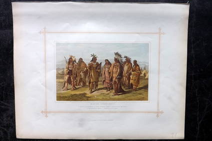
Blackie (Pub) 1882 Folio Print. North American Indians, USAAlbion Auctions4.6(336)See Sold PriceMar 07, 2024
New and Correct Map of North America With the West India Islands,Jasper524.5(9.8k)See Sold PriceFeb 27, 2024
Chart: United States- East Coast/ NORTH CAROLINA/ RIVER INLET TO CAPE FEAR.Churchill Galleries3.7(213)See Sold PriceFeb 26, 2024
2023 Ivory Coast Gold Big Five North America 5-Coin SetGolden Gate Auctioneer4.1(273)See Sold PriceFeb 25, 2024
2023 Ivory Coast Gold Big Five North America 5-Coin Set3 Kings Auction4.3(194)See Sold PriceFeb 28, 2024
Blackie (Pub) 1882 Folio Map. West USA - Pacific StatesAlbion Auctions4.6(336)See Sold PriceMar 01, 2024
Blackie (Pub) 1882 Folio Map. United States of North AmericaAlbion Auctions4.6(336)See Sold PriceMar 01, 2024


![[SHIPWRECKS]. Manuscript testimony (court duplicate) of Thomas Kent, a Black man aboard the (1 of 5)](https://p1.liveauctioneers.com/197/319238/171468014_1_x.jpg?height=282&quality=70&version=1707520367)