SoldEarly Picturesque Atlas of Australia,including maps, illustrations and charts/ af, together with "The Voyages in The E.I.S Marlborough on her passage from London to Calcutta in 1865-66", (2)See Sold Price
SoldAustralia, First 100 YearsBeing a facsimile of volumes I & II of the picturesque atlas of Australia - 1888. First 100 years of Life in Australia. Picturesque Atlas of Australia. Pictorial paperback with title. Title + vignetteSee Sold Price
Australia 1886 Map of New South Wales, Sydney"A Survey of the Settlement in New South Wales New Holland" Lithograph Map (after manuscript) Published 1886-88, Sydney for "Picturesque Atlas of Australia" by Andrew Garran. Engraved by Dulon & PoateSee Sold Price
Australia 1886 Map of New South Wales, Sydney"A Survey of the Settlement in New South Wales New Holland" Lithograph Map (after manuscript) Published 1886-88, Sydney for "Picturesque Atlas of Australia" by Andrew Garran. Engraved by Dulon & PoateSee Sold Price
Australia 1886 Map of New South Wales, Sydney"A Survey of the Settlement in New South Wales New Holland" Lithograph Map (after manuscript) Published 1886-88, Sydney for "Picturesque Atlas of Australia" by Andrew Garran. Engraved by Dulon & PoateSee Sold Price
SoldAustralia.- GarranAustralia.- Garran (Andrew, editor) Picturesque Atlas of Australia, 3 vol., engraved portrait of Cook, wood-engraved plates and illustrations, colour maps, most double-page or folding, some spSee Sold Price
Australia 1886 Map of New South Wales, Sydney"A Survey of the Settlement in New South Wales New Holland" Lithograph Map (after manuscript) Published 1886-88, Sydney for "Picturesque Atlas of Australia" by Andrew Garran. Engraved by Dulon & PoateSee Sold Price
SoldAustralia.- [Garran - Picturesque Atlas of(Andrew, editor ) Picturesque Atlas of Australasia ] , 3 vol., tinted lithographed portrait of Cook, plates, illustrations, linen-backed folding maps, lacking titles and half-titles, occasional librarSee Sold Price
Garran, Andrew Picturesque Atlas of AustralasiaGarran (Andrew) Picturesque Atlas of Australasia,2 vol., numerous wood-engravings, some full-page, many maps, some colour, some double-page, some foxing and browning, lacks map of Australia, vSee Sold Price
Railway Postal and Telegraph Map of South AustraliaTitle/Content of Map: Railway Postal and Telegraph Map of South Australia Cartographer: EVERSON, A. H./ALEX. J. SCALLY Date: 1888 Publisher: THE PICTURESQUE ATLAS PUBLISHING CO. Size: 31Height - 22.5WSee Sold Price
SoldAustralia.- Garran (Andrew, editor) Australasia IlAustralia.- Garran (Andrew, editor) Australasia Illustrated,3 vol., over 800 wood engravings, contemporary half morocco, folio, Picturesque Atlas Publishing Company, Sydney, 1892.See Sold Price
Antique Engraving - Carlotta Arch - Jenolan Caves - New South Wales - AustraliaTitle: Antique Engraving - Carlotta Arch - Jenolan Caves - New South Wales - Australia Description: Antique engraving originates from the first edition of the book "Picturesque atlas of Australasia" bSee Sold Price
Antique Engraving - Sturt Street, Ballarat - Victorian Gold Rush - AustraliaTitle: Antique Engraving - Sturt Street, Ballarat - Victorian Gold Rush - Australia Description: Antique engraving originates from the first edition of the book "Picturesque atlas of Australasia" by ASee Sold Price
4 parts from the Australasia Illustrated series, 1892.Heading: (Australia) Author: Garran, Andrew, editor Title: Australasia Illustrated - Parts 52 - 55 Place Published: Sydney and Melbourne Publisher:The Picturesque Atlas Publishing Co. Date PublisSee Sold Price
SoldBavaria / Southern Germany c. 1550Map Title: Sveviae Et Bavariae Descriptio Published: Munster, S., Basel Date: c. 1550 Size: 10 5/8 x 13 1/2 inches. An attractive early woodcut map of Bavaria/ Southern Germany. A picturesque, early wSee Sold Price
Sold1 BookEarly 19th century engraved German atlas of Europe, Africa, Asia, and Australia (Neu Holland), with several city maps and a final plate showing early locomotives. 28 pp., with all pages tipped in oldSee Sold Price
Sold(2) EARLY MID 19TH CENTURY MAPSStieler's Hand Atlas; (1) 1853 Map of Australia and surrounding island, with color highlights; (1) Stulpnagel 1853 map of North and South America, with color highlights; light foxing; heavy rag paper;See Sold Price
SoldTRANQUILLO MOLLO ATLASTRANQUILLO MOLLO ATLAS; Thirty-four maps out of an original fifty-two include America, United Kingdom, Australia, etc., Vienna, late 18th/early 19th c.; Most maps with color; 15'' x 20''See Sold Price
Sold2 EARLY MAPS OF CHINA, JAPAN, AND AUSTRALIA2 EARLY MAPS OF CHINA, JAPAN, AND AUSTRALIA: 2 maps total to include 1) "An Accurate Map of the Islands and Channels between China and New Holland (Australia), published London, 1794, R. Wilkinson, haSee Sold Price
Southern hemisphere Antarctic Australia South America/Africa. THOMSON 1817 mapTITLE/CONTENT OF MAP: 'Southern hemisphere' DATE PRINTED: Published in 1817 IMAGE SIZE: Approx 53.0 x 52.5cm, 20.75 x 20.75 inches (Large); Please note that this is a folding map. TYPE: Antique earlySee Sold Price
Aaron Arrowsmith Early 1800s Map of AsiaAaron Arrowsmith Early 1800s Engraved Map of Asia. Also shows Australia as "New Holland".Paper Size: 8 5/8" x 11"Image Size: 7 1/4" x 9 1/2"Condition: Paper is sound. Plate mark is clearly visible. ThSee Sold Price
SoldMatthaus Merian,c.1638, India Orientalis MapMatthaus Merian, Swiss, 1593-1650, c.1638 Hand Colored Map of India Orientalis et Insulae Adiecentes (with early discoveries in Western Australia) includes Southeast Asia, China, India, the PhilippineSee Sold Price
12 PC. 19TH CENTURY MAP COLLECTION12 PC. 19TH CENTURY MAP COLLECTION: Comprising; 12- Early 19th Century Book maps, of Europe, Asia, Africa, Australia, and a Hemispherical map.See Sold Price
SoldEarly Atlas Blasting Machine No. 3-50Nice early Atlas brand blasting machine model No. 3-50. Displays well with age appropriate wear. UntestedSee Sold Price
EARLY 18TH C. DUTCH CHART OF PACIFIC OCEAN BY FREDERIK DE WIT (1629-1706) WITH CALIFORNIA AS ANThomaston Place Auction Galleries4.4(389)See Sold PriceFeb 24, 2024
LARGE EARLY 18TH C. DUTCH CHART OF UPPER NORTH AMERICA, PIERRE MORTIER (1661-1711), FRAMEDThomaston Place Auction Galleries4.4(389)See Sold PriceFeb 24, 2024
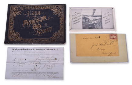
Four Early Railroad Paper Items - Baltimore & Ohio, White Pass & Yukon Route, and Michigan SouthernRail & Road Auctions4.6(165)See Sold PriceMar 07, 2024
4 Throwing/Fighting Clubs, Aboriginal, Eastern Australia, Early 20th C.Material Culture4.6(769)See Sold PriceFeb 29, 2024
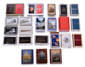
Twenty-Five Canadian Pacific Railway Playing Card DecksRail & Road Auctions4.6(165)See Sold PriceMar 08, 2024
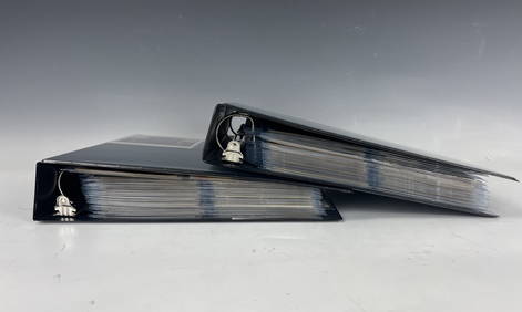
Binders with Some 460 Antique Postcards of Japan Early 20Th CenturyChina Luban Art & Antique, Inc.4.4(78)See Sold PriceFeb 24, 2024
Arrowsmith & Lewis - Map of PolynesiaTrillium Antique Prints & Rare Books4.5(30)See Sold PriceFeb 24, 2024
Arrowsmith & Lewis - Map of North AmericaTrillium Antique Prints & Rare Books4.5(30)See Sold PriceFeb 24, 2024
Arrowsmith & Lewis - Map of the World on Mercator's ProjectionTrillium Antique Prints & Rare Books4.5(30)See Sold PriceFeb 24, 2024
Arrowsmith & Lewis - Map of LouisianaTrillium Antique Prints & Rare Books4.5(30)See Sold PriceFeb 24, 2024
Arrowsmith & Lewis - Map of the United StatesTrillium Antique Prints & Rare Books4.5(30)See Sold PriceFeb 24, 2024
Carey, pub. 1796 - A Chart of the West IndiesTrillium Antique Prints & Rare Books4.5(30)See Sold PriceFeb 24, 2024
Carey, pub. 1796 - Map of the State of MarylandTrillium Antique Prints & Rare Books4.5(30)See Sold PriceFeb 24, 2024
Carey, pub. 1796 - Map of GeorgiaTrillium Antique Prints & Rare Books4.5(30)See Sold PriceFeb 24, 2024
Carey, pub. 1796 - Map of The State of South CarolinaTrillium Antique Prints & Rare Books4.5(30)See Sold PriceFeb 24, 2024
Carey, pub. 1796 - Map of KentuckyTrillium Antique Prints & Rare Books4.5(30)See Sold PriceFeb 24, 2024
Carey, pub. 1796 - Map of the Tennassee State formerly part of North Carolina (Tennessee)Trillium Antique Prints & Rare Books4.5(30)See Sold PriceFeb 24, 2024
Early colonial Africa. Inset Madeira & Aden. SIDNEY HALL 1854 old antique mapJasper524.5(9.8k)See Sold PriceFeb 28, 2024
Early / Signed Chromolithograph - Venetian LandmarksArtemis Fine Arts4.8(1.4k)See Sold PriceFeb 26, 2024