Claude Monet French 1840 - 1926 Oil on canvas Painting Impressionism Renoir Manet Pissarro Era.International Art Auction Gallery4.5(154)See Sold PriceFeb 24, 2024
Antique American Hudson River School Sunset Landscape Framed Original Oil PaintingCurated Gallery Auctions4.6(120)See Sold PriceFeb 25, 2024
Robert William Wood (1889 - 1979) Texas BluebonnetsPremier Auction Galleries4.3(329)See Sold PriceMar 09, 2024
BIRGER SANDZEN (1871-1954) COLORADO OIL ON CANVAS 1936Soulis Auctions4.8(953)See Sold PriceFeb 24, 2024
George Adomeit (American 1879-1964) CAPE COD LandscapePremier Auction Galleries4.3(329)See Sold PriceMar 09, 2024
Vincent Van Gogh Dutch 1853-1890 Oil on canvas. Paul Gaugin, Cezanne, Degas EraInternational Art Auction Gallery4.5(154)See Sold PriceFeb 24, 2024
Renaissance Old Master Altarpiece Adoration Magi Oil Painting Christ Child Virgin Mary Wise MenHess Fine Auctions4.5(197)See Sold PriceMar 02, 2024
19TH C GERMAN OIL PAINTING BY EMIL ZSCHIMMER C 1872Antique Arena Inc.4.5(852)See Sold PriceFeb 24, 2024
JOHN CONSTABLE ANTIQUE ENGLISH CLOUDS OIL PAINTINGAntique Arena Inc.4.5(852)See Sold PriceFeb 24, 2024
ATTRIBUTED TO GILBERT STUART (MA/RI/UK, 1755-1828)Thomaston Place Auction Galleries4.4(386)See Sold PriceFeb 24, 2024
Pablo Picasso Spanish 1881-1973 Oil On Canvas Painting Dali Magritte Braque Juan GrisInternational Art Auction Gallery4.5(154)See Sold PriceFeb 24, 2024
ATTRIB Francisco Miralles Y Galup (Spain,France,1848-1901) oil painting antiqueBroward Auction Gallery4.8(277)See Sold PriceMar 10, 2024
AMERICAN SCHOOL (Early 20th c) Two WorksJohn McInnis Auctioneers,LLC4.6(502)See Sold PriceFeb 25, 2024
Marc Chagall-Limited Edition -Paris Opera Ceiling after ChagallArt Legacy Auctions4.5(217)See Sold PriceFeb 24, 2024
SoldEARLY FRENCH MAP OF NEW ENGLANDHand-colored. Ca 1750-1760. Map in French. Map 14 1/2 x 12 1/2 inches. Fold marks and water stains. Overall 21 inches x 19 inches. Stains and cut down.See Sold Price
SoldEARLY FRENCH MAP "du Roy",dated 1632 colored sigEARLY FRENCH MAP "du Roy",dated 1632 colored sight- 16" x 20"See Sold Price
SoldRARE EARLY FRENCH MAP OF RUSSIAHubert Jaillot: "La Russie Blanche ou Moscovie Divisee Suivant l'Estendue Des Royaumes Duches. . . qui sont Presentement Sous la Domination Du Czar De La Russie" . . . 168(3). Copperplate engraSee Sold Price
SoldEARLY FRENCH MAPS OF VIRGINIA AND MARYLAND, LOT OF TWOEARLY FRENCH MAPS OF VIRGINIA AND MARYLAND, LOT OF TWO hand-colored, the first captioned "der Jungfrauen Landt / Fig. 15", with title in upper proper right corner "VIRGINIE", showing the Chesapeake BaSee Sold Price
SoldFRAMED FRENCH MILITARY ARMED FORCES MAPFramed French map, late 19th/ early 20th c., by Henri Bressler, decorative map of France surrounded by images of the French armed forces, over inset map of Corse and Algeria, published by de VaugirardSee Sold Price
SoldEarly 1900s World Map of French Colonies -- LigueTitle: Early 1900s World Map of French Colonies -- Ligue Maritime et Coloniale Francaise Date: early 1900s Cartographer: Reconnue d'Utilite Publique Size: 29.5 X 44.5 in. Additional Information: ThisSee Sold Price
SoldThree maps, late 18th-early 19th centuryThree mapslate 18th-early 19th centuryComprising a French hand-colored copperplate map of Virginia, 1760-1762; a map of the United States, 1719, by H.A. Chatelain, Amsterdam; and a map of Delaware, 18See Sold Price
Sold1884 Early History of Illinois Breese French1884 Early History of Illinois Breese French Exploration Americana MAPS Indians “The Early History of Illinois” is a late 19th-century account of the settlement and exploration of the state of IllSee Sold Price
SoldEarly French Colonies North America HERMAN MOLL C1732Details: MOLL, Herman (1654-1732). A New Map of ye North Parts of America claimed by France under ye Names of Louisiana, Mississipi, Canada & New France, with the Adjoyning Territories of England & SSee Sold Price
SoldAntique French Map of St. AugustineAntique French Map of St. Augustine, "Plan de la Ville et Port de St. Augustin", late 18th/early 19th c., hand-colored engraved map, sight 8 1/2 in. x 12 in., framed. Provenance: Estate of Faith K. TiSee Sold Price
Sold18th Century French Map of North AmericaL’Amerique Septentrionale. Daniel de la Feuille (1640-1709). Engraved map with hand color in full. Amsterdam, 1702 or 1706. 6 x 8 inches visible, 13 x 14 1/2 inches framed. Nicely colored early 18thSee Sold Price
Weigel: Antique Map of Southern French Antilles, 1718Insulae Antillae Franciae Inferiores A dramatic German early 18th-century map of lower French Antilles, including St. Lucia, St. Vincent and the Grenadines, Grenada, and Barbados, based on "written coSee Sold Price
SoldEARLY UNITED STATES MAPEARLY UNITED STATES MAP: Early American map by Charles Francois Delmarche (French, 1740-1811). Map of Etats-Unis dated 1785. Approx. 31" l x 22" l.See Sold Price
SoldNapoleon Patinated Spelter Table Lamp Napoleon Patinated Spelter Table Lamp French, early 20th century. A patinated spelter table lamp depicting Napoleon sitting at a table where he studies an unfolded map in preparation for the BattleSee Sold Price
Sold1739 Astronomy Galileo Telescope Illustrated Zodiac MAP1739 Astronomy Galileo Telescope Illustrated Zodiac MAPS Optics Pluche Noël-Antoine Pluche was an early 18th-century French priest and historian who is most remembered today for his landmark work ofSee Sold Price
Sold1742 Astronomy Galileo Telescope Illustrated Zodiac MAP1742 Astronomy Galileo Telescope Illustrated Zodiac MAPS Optics Phoenicia Pluche Noël-Antoine Pluche was an early 18th-century French priest and historian who is most remembered today for his land maSee Sold Price
Sold1742 Astronomy Galileo Telescope Illustrated Zodiac MAP1742 Astronomy Galileo Telescope Illustrated Zodiac MAPS Optics Phoenicia Pluche Noël-Antoine Pluche was an early 18th-century French priest and historian who is most remembered today for his land maSee Sold Price
SoldANTIQUE MAPS OF FRENCH CITIES, ROUEN, PARIS, CAHORSIncludes map etching of Cahors and environs, 5 x 3 inch sight size, 11 x 9.5 inch frame. 'Gouvernement de Chaors,' 5 x 7 inch sight size, in 11.75 x 13.75 inch frame. Early 'Rouen' with Seine River, 1See Sold Price
SoldAN EARLY 19TH CENTURY FRENCH GILT AND PATINATED BRONZEAN EARLY 19TH CENTURY FRENCH GILT AND PATINATED BRONZE EMPIRE STYLE MANTEL CLOCK ON NAPOLEONIC THEME the case surmounted by a figure of Napoleon with arms crossed, his flag, map and a laurel wreath orSee Sold Price
Sold1785 ATLAS MAPS & Voyages Travel Geography Asia Arabia1785 ATLAS MAPS & Voyages Travel Geography Asia Arabia BEAUTIFUL Noël-Antoine Pluche was an early 18th-century French priest and historian who is most remembered today for his landmark work of naturaSee Sold Price
Sold[Early Louisiana Geology][Early Louisiana Geology], R. Thomassy, Geologie Pratique de la Louisiane, published in New Orleans and Paris, 1860, in French, illustrated with 5 maps, some fold-out of the Mississippi and illustratiSee Sold Price
SoldEarly Map of the 17th-Century Louisiana ProvinceRare Early Map of the 17th-Century Louisiana Province by Johann Baptist Homann (German, 1664-1724), after Father Louis Hennepin's 1687 account, hand-colored copper engraved map with Latin and French dSee Sold Price
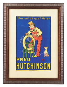
FRENCH PNEU HUTCHINSON "PLUS SOLIDE QUE L'ACIER" FRAMED POSTER W/ DOG GRAPHIC.Dan Morphy Auctions4.2(1.3k)See Sold PriceFeb 25, 2024
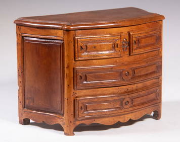
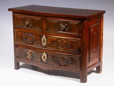
EARLY FRENCH WALNUT MINIATURE COMMODE AS JEWEL BOXThomaston Place Auction Galleries4.4(386)See Sold PriceFeb 24, 2024
EARLY FRENCH WALNUT MINIATURE COMMODEThomaston Place Auction Galleries4.4(386)See Sold PriceFeb 24, 2024
LATE 17TH C. FRENCH MAP OF THE NEW WORLD BY ALEXIS-HUBERT JAILLOT (1632-1712)Thomaston Place Auction Galleries4.4(386)See Sold PriceFeb 24, 2024
Italo-Corinthian Terracotta Aryballos with SoldiersTimeLine Auctions Ltd.4.5(183)See Sold PriceMar 06, 2024
Le Petit Magicien, ou Recueil D’Expériences Tirée de la Mag...Potter & Potter Auctions4.6(539)See Sold PriceFeb 24, 2024
Battle of the Nile: Disposition of the English & French Fleets, at the Commencement of the Action,Trillium Antique Prints & Rare Books4.5(30)See Sold PriceFeb 24, 2024
WEST AFRICA Explorers' routes Senegal Ashanti. Mountains of Kong. SDUK 1857 mapJasper524.5(9.8k)See Sold PriceFeb 28, 2024


![[Early Louisiana Geology] (1 of 3)](https://p1.liveauctioneers.com/268/37440/15804848_1_x.jpg?height=282&quality=70&version=1360341574)