E. Bowen: A New & Accurate Map of Brasil, 1770Map: A New & Accurate Map of Brasil Maker: Emanuel Bowen Published: London, 1770 Size: Folio - 13.75 H x 16.75 W Inches "Divided into its Captainships drawn from the most approved modern maps & chartsSee Sold Price
Bowen: Antique Map of Brazil, 1770Map: A New & Accurate Map of Brasil. Publication Date: 1770 ca. Authors: E. BOWEN, BOWEN, EMANUEL Publisher: E. BOWEN Size: Folio – 13.75 H x 16.75 W Inches "Divided into its Captainships drawn fromSee Sold Price
Bowen: A New & Accurate Map of Brasil, 1770Map: A New & Accurate Map of Brasil Maker: Emanuel Bowen Published: 1770 in London Size: Folio, 13.75 x 16.75 inches "Divided into its Captainships drawn from the most approved modern maps & charts, rSee Sold Price
New & Accurate Map of Brasil.Title/Content of Map: New & Accurate Map of Brasil. Date: 1770 ca. Cartographer: BOWEN, EMANUEL Size: 13.75X16.75 "Divided into its Captainships drawn from the most approved modern maps & charts, reguSee Sold Price
SoldE. Bowen, A New & Accurate Map of China. 1747Emanuel Bowen, 'A New & Accurate Map of China Drawn from Surveys made by Jesuit Missionaries'. London, 1747. Impression measures 14x17'' on 16x18.25'' sheet. Slight discoloration of paper around lowerSee Sold Price
SoldEmanuel Bowen, "New & Accurate Map of Brasil"Emanuel Bowen (English, 1693-1767). "A New & Accurate Map of Brasil, Divided into its Captainships". An engraved map, with vibrant hand coloring, depicting Brasil and a segment with the Isle of St. KaSee Sold Price
SoldA small, mixed group of prints and mapsA small, mixed group of prints, views and maps, including views of Bristol, Gloucester and Portsmouth, Hogarth's The Bench, two birds after Lear, E. Bowen's New and Accurate Map of SwitzerlanSee Sold Price
SoldBowen (E) A New & Accurate Map of GermanyBowen (Emanuel) A New & Accurate Map of Germany,Europe, extending from Denmark and the Netherlands, to the borders of Italy and the Balkan States, decorative vignette title, engraved map withSee Sold Price
SoldE. Bowen 18th century map, Southeast,"A New & Accurate Map of the Provinces of North & South Carolina Georgia & C." by Emmanuel Bowen, showing towns, forts, Indian tribes, and geographical features just prior to the French and Indian WarSee Sold Price
Sold1747 Bowen Map of Kingdoms of Naples and Sicily -- ATitle: 1747 Bowen Map of Kingdoms of Naples and Sicily -- A New & Accurate Map of the Kingdoms of Naples & Sicily … Date: 1747 c., London Cartographer: E Bowen Size: 12.6 X 8.7 in. Additional InformSee Sold Price
SoldSouth America.- Bowen (Emanuel) Four maps, including:South America.- Bowen (Emanuel) Four maps, including: 'A New and Accurate Map of Brasil'; '... Chili, Terra Magellanica, Terra del Fuego &c.'; '... Peru and the Country of the Amazones'; and '... ParaSee Sold Price
SoldBowen: Map of Brasil Divided into Captainships, 1747Map: A New & Accurate Map of Brasil. Divided into its Captainships Cartographer: Bowen Place & Date: London / 1747 Size: 16 3/4" x 13 5/8" Bowen's wonderfully detailed map of Brazil, from his A CompleSee Sold Price
Maps, E. Bowen [Russia, Eastern Europe]**** 1: A New and Accurate Map of Moscovy, or Russian in Europe. 12.5" x 8.75". **** 2: A New and Accurate Map of Poland, Lithuania.... 16.75" x 13.5". **** 3: A New and Accurate Map of the Kingdom ofSee Sold Price
Maps, E. Bowen [Great Britain]**** 1: A New and Very Accurate Map of South Britain or England & Wales drawn… 16.5" x 13.5". One corner chipped, another rounded. **** 2: A New and Accurate Map of Scotland Compiled from SurveySee Sold Price
Maps, E. Bowen [France, Europe]**** 1: A New and Accurate Map of France with its Acquisitions composed from the latest surveys... 12.5" x 8.75". Crease and small holes to upper corner. **** 2: A New and Accurate Map of France withSee Sold Price
SoldGroup of Four Maps by Thomas Bowen (-1790), "A NewGroup of Four Maps by Thomas Bowen (-1790), "A New Acurate Map of North America… For Middleton's Compleat Geography," "Map of Europe," "A New Accurate Map of E. Moscovy or Russia in Europe," 174See Sold Price
SoldMap, West Indies, N&S Amer. Coasts E. Bowen 1745A New & Accurate Chart of the West Indies with the Adjacent Coasts of North & South America' 'Drawn from the Best Authorities . . . .by Emanuel Bowen (mid 1700's), Geographer to His Majesty'. PublisheSee Sold Price
1750 Bowen Map of Bermuda and St. Kitts -- A New & Accurate Map of Bermudas or Sommer's Islands...Title: 1750 Bowen Map of Bermuda and St. Kitts -- A New & Accurate Map of Bermudas or Sommer's Islands... [on sheet with] An Accurate Map of the Island of St. Christopher… Cartographer: E BowenSee Sold Price
1747 BOWEN EMANUEK (1714 ca - 1767) INCISIONE in bianco1747 BOWEN EMANUEK (1714 ca - 1767) INCISIONE in bianco e nero "A new & accurate map of the kingdoms of Naples & Sicily" (cm 52 x 35) Drawn from the most approved foreign maps & charts, and regulatedSee Sold Price
1750 Bowen Map of Bermuda and St. Kitts -- A New & Accurate Map of Bermudas or Sommer's Islands...Title: 1750 Bowen Map of Bermuda and St. Kitts -- A New & Accurate Map of Bermudas or Sommer's Islands... [on sheet with] An Accurate Map of the Island of St. Christopher… Cartographer: E BowenSee Sold Price
SoldThomas Bowen. Map of North America, circa 1770(British, d. 1790). "A New and Accurate Map of North America," hand colored engraving for Middleton's Complete System of Geography, 11 1/4 x 17 3/4 in., framedSee Sold Price
Bowen: Antique Map of England & Wales, 1747Map: 1747 Bowen Map of England and Wales -- A New and Very Accurate Map of South Britain or England and Wales... Cartographer: E Bowen Year / Place: 1847 c., London Map Dimensions: 15.5 X 16.5 in. ConSee Sold Price
Sold1747 Bowen Map of England and Wales -- A New and VeryTitle/Content of Map: 1747 Bowen Map of England and Wales -- A New and Very Accurate Map of South Britain or England and Wales... Cartographer: E Bowen Year/Place: 1847 c., London Size: 15.5 X 16.5 inSee Sold Price
Bowen: Map of England and Wales, 1747Map: 1747 Bowen Map of England and Wales -- A New and Very Accurate Map of South Britain or England and Wales... Cartographer: E Bowen Year / Place: 1847 c., London Map Dimensions: 15.5 X 16.5 in. ThiSee Sold Price
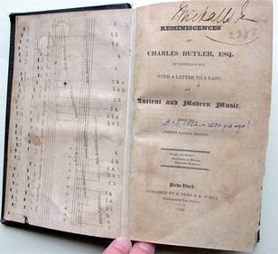
Charles Butler Ancient & Modern Music 1824 1st Edition Scarce MusicLuis Porretta Fine Arts4.3(10)See Sold PriceMar 02, 2024
OGILVY & BOWEN c1736 Original Map of Oxfordshire Berkshire Etc.Luis Porretta Fine Arts4.3(10)See Sold PriceMar 02, 2024
[ARCTIC]. BOWEN, Emanuel. A New & Accurate Map of the North...Potter & Potter Auctions4.6(545)See Sold PriceMar 07, 2024
Johann Homann Hand-Colored Map Engraving, c. 1730Auctions at Showplace4.6(740)See Sold PriceMar 17, 2024
Audubon, Amsterdam Ed - American Robin. 131Trillium Antique Prints & Rare Books4.5(32)See Sold PriceFeb 24, 2024
Map: An 18thC engraved map of Bedfordshire titled An Accurate Map of the County of Bedford DividedClaydon Auctioneers Ltd4.3(125)See Sold PriceFeb 26, 2024
1855 NOTES ON CENTRAL AMERICA by E. G. Squier antique w/ MAPSJasper524.5(9.9k)See Sold PriceFeb 27, 2024
1764 MAP OF COUNTRIES THIRTY MILES ROUND LONDON antique 12.5 by 15"Jasper524.5(9.9k)See Sold PriceFeb 27, 2024
1738 RUSSIA SIBERIA & GREAT TARTARY Description illustrated ANTIQUE in ENGLISHJasper524.5(9.9k)See Sold PriceFeb 27, 2024
Fielding (Henry) The Works, with An Essay on His Life and Genius by Arthur Murphy, 10 vol., newForum Auctions4.3(53)See Sold PriceFeb 29, 2024
Kent & Sussex.- Moss (W.G.) The History and Antiquities of the Town and Port of Hastings, 1824; andForum Auctions4.3(53)See Sold PriceFeb 29, 2024
1750 Bowen Map of Bermuda and St. Kitts -- A New & Accurate Map of Bermudas or Sommer's Islands...Jasper524.5(9.9k)See Sold PriceFeb 27, 2024
New and Correct Map of North America With the West India Islands,Jasper524.5(9.9k)See Sold PriceFeb 27, 2024


![Maps, E. Bowen [Russia, Eastern Europe] (1 of 7)](https://p1.liveauctioneers.com/3532/79779/41533573_1_x.jpg?height=282&quality=70&version=1444167022)
![Maps, E. Bowen [Great Britain] (1 of 7)](https://p1.liveauctioneers.com/3532/79779/41533571_1_x.jpg?height=282&quality=70&version=1444167022)
![Maps, E. Bowen [France, Europe] (1 of 5)](https://p1.liveauctioneers.com/3532/79779/41533569_1_x.jpg?height=282&quality=70&version=1444167022)


![[ARCTIC]. BOWEN, Emanuel. A New & Accurate Map of the North... (1 of 1)](https://p1.liveauctioneers.com/928/318880/171360917_1_x.jpg?height=282&quality=70&version=1707501302)