SoldDury (Andrew) - An Actual Survey of the Provinces ofthe survey by Major James Rennell, Surveyor General to the honourable the East India Company, engraved map with original hand-colouring on 2 sheets, unjoined, approx 995 x 1500mm., if joined, the sheeSee Sold Price
SoldIndia.- Dury (Andrew) An Actual Survey of the ProvincesIndia.- Dury (Andrew) An Actual Survey of the Provinces of Bengal, Bahar &c., By Major James Rennell [...] published from a drawing by A. Dury, large two-sheet wall map of Bengal, illustrating the couSee Sold Price
Laurie & Whitle, "An Actual Survey of the Provinces ofLaurie & Whitle, "An Actual Survey of the Provinces of Bengal, Bohar, etc. by James Rennell from a map by Andrew Dury," 1794, in two parts, Each- H. - 21 1/2 in., W. - 28 3/4 in. (2 Pcs.)See Sold Price
SoldEAS[T]BURN, Benjamin [but after Nicholas SCULL, MEAS[T]BURN, Benjamin [but after Nicholas SCULL, Matthew CLARKSON and Mary BIDDLE]. A Plan of the City of Philadelphia, the Capital of Pennsylvania, from an Actual Survey.London: Andrew Dury, 4See Sold Price
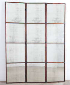
SoldHERTFORDSHIRE. DURY, ANDREW & JOHN ANDREWSHertfordshire. Dury, Andrew and John Andrews. A Topographical Map of Hartford-Shire, from an Actual Survey, folding dissected map backed on to linen, on 36 sheets, a few manuscript marks, offsetting,See Sold Price
SoldDury (Andrew) and P. Bell. Environs of London takeDury (Andrew) and P. Bell. Environs of London taken from Actual Surveys,1st edition, from Luton to Bletchingley and from Canvey Island to Great Marlow, title vignette upper left, engraved mapSee Sold Price
SoldAndrew Dury and John Andrews, 'A Topographical Map ofAndrew Dury and John Andrews, 'A Topographical Map of Hartford-shire From An Actual Survey...', hand coloured engraving, published 1766, mounted over margins, 52 x 69cm; and: Robert Morden, 'ShropshirSee Sold Price
London.- Andrews (John) and Andrew Dury. - A Map of theand Andrew Dury. A Map of the Country Sixty Five Miles Round London from Actual Surveys, 19 of 20 double-page sheets, lacking sheet 12 due west of London, with large oval title on sheet 1, dedicationSee Sold Price
SoldAndrews (John)Andrews (John) and Andrew Dury. A Map of the Country Sixty Five Miles Round London from Actual Surveys, engraved map on 20 double-page sheets with large oval title on sheet 1, dedication ovalSee Sold Price
Dury, Andrew A map of the provinces of Delhi, Agrah,Dury, Andrew A map of the provinces of Delhi, Agrah, Oude and Allahabad. Teilkolorierte Kupferstichkarte in 2 Teilen (nicht zusammengesetzt). London, Laurie & Whittle, 1794. 109 x 107 cm. Große, detaSee Sold Price
SoldIndia.- Dury (Andrew) A Map of the Provinces of Delhi,India.- Dury (Andrew) A Map of the Provinces of Delhi, Agrah, Oude, and Ellahabad, comprehending the Countries lying between Delhi, and the Bengal-Provinces, Surveyed by James Rennell, large two-sheetSee Sold Price
Sauthier's Map of New York 1776A Map of the Province of New-York Reduc'd from the large Drawing of that Province, Compiled from actual Surveys by Order of His Excellency William Tryon Esqr. Captain General & Governor of the Same, BSee Sold Price
SoldKITCHIN, THOMAS; and DURY, ANDREW. British Dominions inKITCHIN, THOMAS; and DURY, ANDREW. British Dominions in America Agreeable to the Treaty of 1763; Divided into the Several Provinces and Jurisdictions. Double-page engraved map of colonial North AmericSee Sold Price
SoldNorfolk.- Bryant (Andrew) Map of the County of Norfolk,Norfolk.- Bryant (Andrew) Map of the County of Norfolk, From an Actual Survey, vignette view of Norwich Cathedral lower right, with key to map lower left, large engraved folding map, in six sections,See Sold Price
Norfolk.- Bryant (Andrew) Map of the County of Norfolk,Norfolk.- Bryant (Andrew) Map of the County of Norfolk, From an Actual Survey, vignette view of Norwich Cathedral lower right, with key to map lower left, large engraved folding map, in six sections,See Sold Price
SoldMontresor, Map of Province of New YorkMONTRESOR, John (1736-1799). A Map of the Province of New York with Part of Pensilvania and New England from an actual survey by Captain Montresor, Engineer, 1775. Engraved map with original color inSee Sold Price
SoldBBRI Dury (Andrew) A Collection of Plans of the PrBBRI Dury (Andrew) A Collection of Plans of the Principal Cities of Great Britain and Ireland,with Maps of the Coast of the Said Kingdoms, Drawn from the most Accurate Surveys, In particular tSee Sold Price
SoldMONTRESOR, John. Map of the Province of New York,MONTRESOR, John. Map of the Province of New York, with Part of Pennsylvania, and New England...Map of the Province of New York, with Part of Pennsylvania, and New England, from an Actual SurveSee Sold Price
EAST INDIA COMPANY Map of the provinces oEAST INDIA COMPANY Map of the provinces of Bengal, Bahar, etc. by Andrew Dury, 1776. 21 x 147 cms. Hogarth frame. Printed on two sheets, hand coloured in outline.See Sold Price
1774 Jeffrey's Map of the Most Inhabited Part of New"Containing the Provinces of Massachusets Bay and New Hampshire with the Colonies of Conecticut and Rhode Island Divided into Counties and Townships; the whole completed from Actual Surveys and its SiSee Sold Price
Montresor's mapping of the Hudson River watershedMONTRESOR, John (1736- 1799). A Map of the Province of New York with Part of Pensilvania and New England from an actual survey by Captain Montresor, Engineer, 1775. Engraved map with original color inSee Sold Price
John MontresorMap of the Province of New York, with Part of Pennsylvania , and New England, from an Actual Survey by Captain Montresor, Engineer, 1775. Copperplate engraving with original outline hand color Paper sSee Sold Price
SoldAntique Map of PennsylvaniaHand-painted copper engraved antique map, "A Map of Pennsylvania Exhibiting not only The Improved Parts of that Province, but also its Extensive Frontiers. Laid down from actual surveys, and chiefly fSee Sold Price
SoldDetailed colored map of Nova Scotia, 1861Heading: (Nova Scotia) Author: MacKinlay, A. & W. Title: MacKinlay's Map of the Province of Nova Scotia, Including the Island of Cape Breton. Compiled by Actual Recent Surveys Place Published: LiverpoSee Sold Price
OGILVY & BOWEN c1736 Original Map of Oxfordshire Berkshire Etc.Luis Porretta Fine Arts4.3(10)See Sold PriceMar 02, 2024
1860 Life of Andrew Jackson Battle of NEW ORLEANS War of 1812 Alexander WalkerSchilb Antiquarian Rare Books4.8(428)See Sold PriceMar 31, 2024
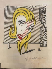
ANDY WARHOL - COMMITTEE 2000 - OIL ON CANVAS - IN THE STYLE OFThe Art's World4.3(1)See Sold PriceFeb 27, 2024
ANDY WARHOL - MICK JAGGER - OIL ON CANVAS - IN THE STYLE OFThe Art's World4.3(1)See Sold PriceFeb 27, 2024
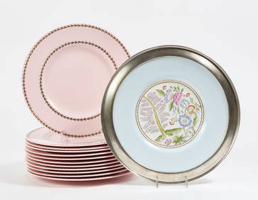
A set of twelve Cauldon porcelain dinner platesAndrew Jones Auctions4.7(208)See Sold PriceFeb 28, 2024
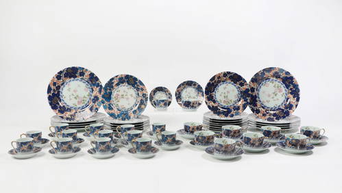
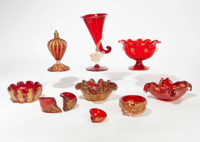
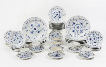
A Haviland Limoges porcelain part dinner serviceAndrew Jones Auctions4.7(208)See Sold PriceFeb 28, 2024
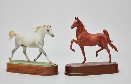
Two Royal Worcester porcelain models of horsesAndrew Jones Auctions4.7(208)See Sold PriceFeb 28, 2024
A set of twelve Wedgwood porcelain dinner platesAndrew Jones Auctions4.7(208)See Sold PriceFeb 28, 2024
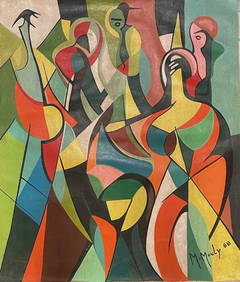
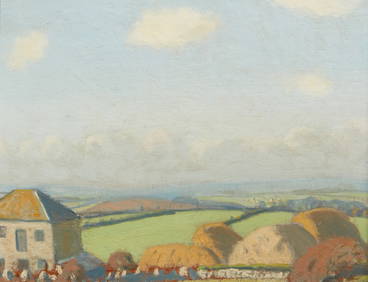
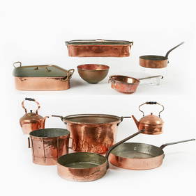
Robert Morson Hughes, Farm Buildings in CornwallAndrew Jones Auctions4.7(208)See Sold PriceFeb 28, 2024
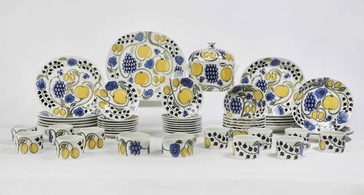
An Arabia of Finland ceramic part dinner serviceAndrew Jones Auctions4.7(208)See Sold PriceFeb 28, 2024
A Royal Copenhagen porcelain part dinner serviceAndrew Jones Auctions4.7(208)See Sold PriceFeb 29, 2024


![EAS[T]BURN, Benjamin [but after Nicholas SCULL, M (1 of 1)](https://p1.liveauctioneers.com/839/17444/5912330_1_x.jpg?height=282&quality=70&version=1226588954)