SoldDesnos 1765 Map. Paris to Bordeaux. France"Ille Feuille Qui donne les Routes de Paris a Bordeaux et Toulouse &Ca" Copper Engraved Map Published 1765, Paris for "Coup d'oeil general sur la France" by Louis Charles Desnos & Louis Brion de la ToSee Sold Price
SoldDesnos 1765 Map of S. W. France. Bordeaux, NantesCopper Engraved Map Published 1765, Paris for "Coup d'oeil general sur la France" by Louis Charles Desnos & Louis Brion de la Tour. Paper Size: 14 x 11 inch (36 x 28cm) Minor toning/staining, otherwisSee Sold Price
SoldDesnos 1765 Map. Paris to Basle. France Switzerland"Feuille Qui donne les Routes de Champagne, Lorraine, Franche Comte: Partie de la Bourgogne et de l'Alsace" Copper Engraved Map Published 1765, Paris for "Coup d'oeil general sur la France" by Louis CSee Sold Price
SoldDesnos 1765 Map. Paris to Frankfurt. France Germany"Fle L'Indicateur Fidele, Donne la Troisieme Route de Paris a Strasbourg..." Copper Engraved Map Published 1765, Paris for "Coup d'oeil general sur la France" by Louis Charles Desnos & Louis Brion deSee Sold Price
SoldDesnos 1765 Map. Paris to Strasbourg, France"L'Indicateur Fidele du Voyageur Francois qui donne la 3me Route de Paris a Strasbourg" Copper Engraved Map Published 1765, Paris for "Coup d'oeil general sur la France" by Louis Charles Desnos & LouiSee Sold Price
SoldDesnos, Louis Charles 1765 Map of Paris, France"Pmiere. Flle. de l'Indicateur Fidele du Voyageur Francois" City Plan of Paris, showing routes out of the city to other parts of France. Copper Engraved Map Published 1765, Paris for "Coup d'oeil geneSee Sold Price
SoldDesnos 1765 Map of the Route from Paris to LyonCopper Engraved Map Published 1765, Paris for "Coup d'oeil general sur la France" by Louis Charles Desnos & Louis Brion de la Tour. Paper Size: 14 x 11 inch (36 x 28cm) Minor toning. Old manuscript inSee Sold Price
SoldDesnos 1765 Map of the Route from Paris to NantesCopper Engraved Map Published 1765, Paris for "Coup d'oeil general sur la France" by Louis Charles Desnos & Louis Brion de la Tour. Paper Size: 14 x 11 inch (36 x 28cm) Very minor toning. Old manuscriSee Sold Price
SoldDesnos 1765 Map of the Route from Strasbourg to Paris"L'Indicateur Fidele du Voyageur Francois" Copper Engraved Map Published 1765, Paris for "Coup d'oeil general sur la France" by Louis Charles Desnos & Louis Brion de la Tour. Paper Size: 17 x 11 inchSee Sold Price
SoldDesnos 1765 Map of South France, Marseilles Toulon"L'Indicateur Fidele du Voyageur Francois" Copper Engraved Map Published 1765, Paris for "Coup d'oeil general sur la France" by Louis Charles Desnos & Louis Brion de la Tour. Paper Size: 14 x 11 inchSee Sold Price
SoldDesnos 1765 Map of Brittany, France. Bretagne"L'Indicateur Fidele qui donne toutes les routes et Chemins de la Bretagne" Copper Engraved Map Published 1765, Paris for "Coup d'oeil general sur la France" by Louis Charles Desnos & Louis Brion de lSee Sold Price
SoldDesnos 1765 Map. Vienna to Strasbourg, France AustriaAlso showing Germany. "Grande Route de Strasbourg a Wienne en Autriche" Copper Engraved Map Published 1765, Paris for "Coup d'oeil general sur la France" by Louis Charles Desnos & Louis Brion de la ToSee Sold Price
SoldDesnos 1765 Map of North East France"Grandes Routes des Provces de Picardie, de Thierache, d'Artois de Hainaut, de la Flandre" Copper Engraved Map Published 1765, Paris for "Coup d'oeil general sur la France" by Louis Charles Desnos & LSee Sold Price
SoldDesnos 1765 Map of the English Channel. UK France"Flle L'Indicateur Fidele du Voyageur Francois du Voyage Francois..." Copper Engraved Map Published 1765, Paris for "Coup d'oeil general sur la France" by Louis Charles Desnos & Louis Brion de la TourSee Sold Price
SoldDesnos 1765 Map of South West France"L'Indicateur Fidele du Voyageur Francois" Copper Engraved Map Published 1765, Paris for "Coup d'oeil general sur la France" by Louis Charles Desnos & Louis Brion de la Tour. Paper Size: 14 x 11 inchSee Sold Price
SoldDesnos 1765 Antique Map of Central France"Feuille Qui donne les Routes et Chemins, tant Royaux que Particuliers, compris entre les deux grandes Routes de Paris" Copper Engraved Map Published 1765, Paris for "Coup d'oeil general sur la FranceSee Sold Price
SoldDesnos, Louis Charles 1765 Map of France"Carte Generale de France" Copper Engraved Map Published 1765, Paris for "Coup d'oeil general sur la France" by Louis Charles Desnos & Louis Brion de la Tour. Paper Size: 14 x 11 inch (36 x 28cm) VerySee Sold Price
Sold1766 Louis Brion de la Tour Paris France Louis Charles1766 Louis Brion de la Tour Paris France Louis Charles Desnos Engraved Map "Mappe-Monde" Dressee pour l'Etude de la Geographie. [Bay of the West] Good Condition. Frame Measures 17-7/8 Inches by 19-1/8See Sold Price
Sold1765 Paris FRANCE City View Maps Architecture Art1765 Paris FRANCE City View Maps Architecture Art Piganiol ILLUSTRATED A rare geographical study of France by Piganiol! Piganiol de la Force was an 18th-century French author known almost exclusivelySee Sold Price
Sold1765 Paris FRANCE City View Maps Architecture Art1765 Paris FRANCE City View Maps Architecture Art Piganiol ILLUSTRATED A rare geographical study of France by Piganiol! Piganiol de la Force was an 18th-century French author known almost exclusivelySee Sold Price
Buffier. Map of Europe. 1765.Print from copper engraving titled „L‘ Europe“.Author/compiler – Buffier.Published in Paris, France in M. DCC. LXV. – 1765.Notes: Septentrion/Orient/Midy/Occident, pag. 9.From „GeographieSee Sold Price
SoldBuffier. Map of Italy. 1765.Print from steel engraving titled „L‘ Italie“.Author/compiler – Buffier.Published in Paris, France in M. DCC. LXV. – 1765.Notes: Septentrion/Orient/Midy/Occident, pag. 177.From „GeographieSee Sold Price
SoldBuffier. Map of France. France. 1765.Print from steel engraving titled „La France“.Author/compiler – Buffier.Published in Paris, France in M. DCC. LXV. – 1765.Notes: Septentrion/Orient/Midy/Occident, pag. 10.From „Geographie UnSee Sold Price
Buffier. Map of the World. 1765.Print from copper engraving titled „Mappe-Monde“.Author/compiler – Buffier.Published in Paris, France in M. DCC. LXV. – 1765.Notes: Septentrion/Orient/Midy/Occident, pag. 7.From „GeographieSee Sold Price
Museum of Horrors - King of Pigs -Emil Zola - 1899Levy Auction House4.3(11)See Sold PriceFeb 27, 2024
Duval - Pair: Map of Georgia & Map of Moscow, RussiaTrillium Antique Prints & Rare Books4.5(30)See Sold PriceFeb 24, 2024
Duval - Pair: Map of India & Map of MaldivesTrillium Antique Prints & Rare Books4.5(30)See Sold PriceFeb 24, 2024
D'Entrecasteaux - Australia: Coasts of Van Diemen's Land (New Holland). 9Trillium Antique Prints & Rare Books4.5(30)See Sold PriceFeb 24, 2024
D'Entrecasteaux - Tasmania, Australia: Map of the Northern Portion of Recherche Bay. 5Trillium Antique Prints & Rare Books4.5(30)See Sold PriceFeb 24, 2024
D'Entrecasteaux - Australia: Chart of Van Diemen's Land (New Holland). 3Trillium Antique Prints & Rare Books4.5(30)See Sold PriceFeb 24, 2024
D'Entrecasteaux - Map of Australia (New Holland), New Zealand, and southern Asia and surroundingTrillium Antique Prints & Rare Books4.5(30)See Sold PriceFeb 24, 2024
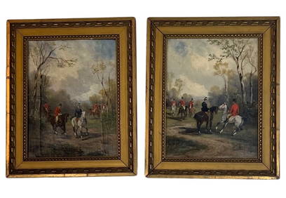
Rene Pierre Charles Princeteau (1843 - 1914) FranceCutler Bay Auctions4.5(168)See Sold PriceFeb 29, 2024
Denis Diderot (1713 - 1784) & Jean Le Rond d’Alembert (1717 - 1783) - Set of 10 Military Prints -Proverde Auctions4.3(3)See Sold PriceFeb 28, 2024
Denis Diderot (1713-1784) & Jean Le Rond d’Alembert - Set of 10 Military Prints - Empty frame [forProverde Auctions4.3(3)See Sold PriceFeb 28, 2024
Carl Johan Billmark - Set of 4 Prints depicting Rome, Italy - Church in Sweden - Views of EuropeProverde Auctions4.3(3)See Sold PriceFeb 28, 2024
Jules Verne, De La Terre a La Lune, Au Steamer Red MacaronLion and Unicorn4.7(1.8k)See Sold PriceMar 10, 2024
Jules Verne, L'Etoile du Sud, Au Steamer Red MacaronLion and Unicorn4.7(1.8k)See Sold PriceMar 10, 2024