MATTHEWS c1856 Map Of Upper Canada Ontario Indian Land Agency Divisions Scarce!Luis Porretta Fine Arts4.3(10)See Sold PriceMar 02, 2024
DEVINE c1856 Dr Salters Map Of Lake Huron Ontario Indian Lands etc. No. 7 ScarceLuis Porretta Fine Arts4.3(10)See Sold PriceMar 02, 2024
DUNLEVIE c1856 Map Counties Of Gaspe & Bonaventure Quebec Canada SCARCE! #1Luis Porretta Fine Arts4.3(10)See Sold PriceMar 02, 2024
DUNLEVIE c1856 Map Counties Of Gaspe & Bonaventure Quebec Canada SCARCE! #2Luis Porretta Fine Arts4.3(10)See Sold PriceMar 02, 2024
Map UNITED COUNTIES LEEDS & GRENVILLE by Walling 1861 Rare Canada Map 5ft x 5ftLuis Porretta Fine Arts4.3(10)See Sold PriceMar 02, 2024
Ambroise TARDIEU c1822 Map Venice Napoleon Italian Campaign 17" x 11"Luis Porretta Fine Arts4.3(10)See Sold PriceMar 02, 2024
de Ferrer: Antique Map of Puerto Antonio, Jamaica, 1809Map: Puerto Antonio, Jamaica, 1809 Date Printed: 1809 Cartographer: Ferrer Material/Medium: Engraving Size: 11 3/4" x 15" Original engraving from José Joaquín de Ferrer y Cafranga's sea atlas, the 'See Sold Price
de Ferrer: Antique Map of Montego Bay, Jamaica, 1809Map: Montego Bay, Jamaica, 1809 Date Printed: 1809 Cartographer: Ferrer Material/Medium: Engraving Size: 11 3/4" x 15" Original engraving from José Joaquín de Ferrer y Cafranga's sea atlas, the 'PorSee Sold Price
de Ferrer: Antique Map of Santa Ana, Jamaica, 1809Map: Santa Ana, Jamaica, 1809 Date Printed: 1809 Cartographer: Ferrer Material/Medium: Engraving Size: 11 3/4" x 15" Original engraving from José Joaquín de Ferrer y Cafranga's sea atlas, the 'PortuSee Sold Price
de Ferrer: Antique Map of Puerto y Fuerte, 1809Map: Puerto y Fuerte de St. Luis, St. Martin Date Printed: 1809 Cartographer: Ferrer Material/Medium: Engraving Size: 11 3/4" x 15" Original engraving from José Joaquín de Ferrer y Cafranga's sea atSee Sold Price
de Ferrer: Antique Map of Puerto del Mole, 1809Map: Puerto del mole de St. Nicolas, Haiti, 1809 Date Printed: 1809 Cartographer: Ferrer Material/Medium: Engraving Size: 11 3/4" x 15" Original engraving from José Joaquín de Ferrer y Cafranga's seSee Sold Price
de Ferrer: Antique Map of Puerto de la Caldera, 1809Map: Puerto de la Caldera, Chile, 1809 Date Printed: 1809 Cartographer: Ferrer Material/Medium: Engraving Size: 11 3/4" x 15" Original engraving from José Joaquín de Ferrer y Cafranga's sea atlas, tSee Sold Price
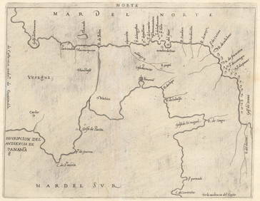
Soldde Ferrer: Antique Nautical Chart of Puerto de ChagresMap: 1809 Nautical Chart of Puerto de Chagres, Panama (Castillo de Lorenzo) Date Printed: 1809 Cartographer: José Joaquín de Ferrer Material/Medium: Engraving Size: 11 3/4" x 15" Original engravingSee Sold Price
Soldde Ferrer: Antique Nautical Chart of Puerto de NaosMap: 1809 Nautical Chart of Puerto de Naos y adyacentes, Panama Date Printed: 1809 Cartographer: José Joaquín de Ferrer Material/Medium: Engraving Size: 11 3/4" x 15" Original engraving from José JSee Sold Price
de Ferrer: Antique Nautical Chart of Puerto de San JuanMap: 1809 Nautical Chart of Puerto de San Juan, Nicaragua Date Printed: 1809 Cartographer: José Joaquín de Ferrer Material/Medium: Engraving Size: 11 3/4" x 15" Original engraving from José JoaquíSee Sold Price
Ferrer: Antique Nautical Chart of Mayaguez, 18091809 Nautical Chart of Mayaguez (Puerto Rico). Original engraving from José Joaquín de Ferrer y Cafranga's sea atlas, the 'Portulano de los Estados Unidos', published in Madrid in 1818. Ferrer devisSee Sold Price
Ferrer: Antique Nautical Chart of Aguadilla, 18091809 Nautical Chart of Aguadilla (Puerto Rico). Original engraving from José Joaquín de Ferrer y Cafranga's sea atlas, the 'Portulano de los Estados Unidos', published in Madrid in 1818. Ferrer deviSee Sold Price
Ferrer: Antique Nautical Chart of Guanica, 18091809 Nautical Chart of Guanica (Puerto Rico). Original engraving from José Joaquín de Ferrer y Cafranga's sea atlas, the 'Portulano de los Estados Unidos', published in Madrid in 1818. Ferrer deviseSee Sold Price
SoldFerrer: Antique Nautical Chart of Tortola BVI, 18091809 Nautical Chart of Tortola BVI. Original engraving from José Joaquín de Ferrer y Cafranga's sea atlas, the 'Portulano de los Estados Unidos', published in Madrid in 1818. Ferrer devised the compSee Sold Price
SoldFerrer: Antique Nautical Chart of Norman Island, 18091809 Nautical Chart of Norman Island BVI (Treasure Island). Original engraving from José Joaquín de Ferrer y Cafranga's sea atlas, the 'Portulano de los Estados Unidos', published in Madrid in 1818.See Sold Price
SoldFerrer: Antique Nautical Chart of Antigua, 18091809 Nautical Chart of Antigua. Original engraving from José Joaquín de Ferrer y Cafranga's sea atlas, the 'Portulano de los Estados Unidos', published in Madrid in 1818. Ferrer devised the compreheSee Sold Price
Soldde Ferrer: Antique Map of Kingston, Jamaica, 1818Map: Kingston, Jamaica, 1818 Date Printed: 1818 Cartographer: José Joaquín de Ferrer Size: 11 3/4" x 15" Original engraving from José Joaquín de Ferrer y Cafranga's sea atlas, the 'Portulano de loSee Sold Price
de Ferrer: Antique Map of Bluefields, Jamaica, 1818Map: Bluefields, Jamaica, 1818 (Arrecife del Moro) Date Printed: 1818 Cartographer: José Joaquín de Ferrer Size: 11 3/4" x 15" Features southwest coast of Jamaica near Bluefields Bay & town of BelmoSee Sold Price
de Ferrer: Antique Map of Lucea, Jamaica, 1818Map: Lucea, Jamaica, 1818 (Hanover) Date Printed: 1818 Cartographer: José Joaquín de Ferrer Size: 11 3/4" x 15" Original engraving from José Joaquín de Ferrer y Cafranga's sea atlas, the 'PortulanSee Sold Price
de Ferrer: Antique Map of Moore's Pen, Jamaica, 1818Map: Moore's Pen, Jamaica, 1818 Date Printed: 1818 Cartographer: José Joaquín de Ferrer Size: 11 3/4" x 15" Map features Great Goat Island, Ridley's Bay, Coleman's Bay, Salt River Bay, Peake Bay, MaSee Sold Price
de Ferrer: Antique Map of Mosquito Cove, Jamaica, 1818Map: Mosquito Cove, Jamaica, 1818 Date Printed: 1818 Cartographer: José Joaquín de Ferrer Size: 11 3/4" x 15" Original engraving from José Joaquín de Ferrer y Cafranga's sea atlas, the 'PortulanoSee Sold Price
de Ferrer: Antique Map Bahia de San Lorenzo, 1809Map: Bahia de San Lorenzo, o de las Perlas, Dominican Republic, 1809 Date Printed: 1809 Cartographer: Ferrer Material/Medium: Engraving Size: 11 3/4" x 15" Original engraving from José Joaquín de FeSee Sold Price
de Ferrer: Antique Map of Bahia Gonaives, Haiti, 1809Map: Bahia Gonaives, Haiti, 1809 Date Printed: 1809 Cartographer: Ferrer Material/Medium: Engraving Size: 11 3/4" x 15" Original engraving from José Joaquín de Ferrer y Cafranga's sea atlas, the 'PoSee Sold Price
de Ferrer: Antique Map of Ciudad de Santo Domingo, 1809Map: Embocadura del rio Ozama y Ciudad de Santo Domingo, Haiti, 1809 Date Printed: 1809 Cartographer: Ferrer Material/Medium: Engraving Size: 11 3/4" x 15" Original engraving from José Joaquín de FeSee Sold Price
de Ferrer: Antique Map of Plano de la Bahia, 1809Map: Plano de la Bahia de Acul, 1809 Date Printed: 1809 Cartographer: Ferrer Material/Medium: Engraving Size: 11 3/4" x 15" Original engraving from José Joaquín de Ferrer y Cafranga's sea atlas, theSee Sold Price
17TH C. ANTIQUE MAP SIEGE OF LA ROCHELLE, FRANCE, FRAMEDThomaston Place Auction Galleries4.4(386)See Sold PriceFeb 24, 2024
De Jode, Rare, pub. 1593 - Map of the Czech Republic or Kingdom of Bohemia (Chorographia insignisTrillium Antique Prints & Rare Books4.5(30)See Sold PriceFeb 24, 2024
De Jode, Rare, pub. 1593 - Map of the Middle East, Eastern Asia (Primae Partis Asiae accurataTrillium Antique Prints & Rare Books4.5(30)See Sold PriceFeb 24, 2024
De Jode, Rare, pub. 1593 - Map of Africa (Africae Vera Forma, et Situs)Trillium Antique Prints & Rare Books4.5(30)See Sold PriceFeb 24, 2024
Vaillant - Hawaii: Stranding in the Sandwich Islands (Echouage aux Iles Sandwich). 43Trillium Antique Prints & Rare Books4.5(30)See Sold PriceFeb 24, 2024
Vaillant - Kealakekua Bay, Hawaii (Village de Kearakekoua, Iles Sandwich). 44Trillium Antique Prints & Rare Books4.5(30)See Sold PriceFeb 24, 2024
Vaillant - Honolulu, Hawaii (Vue de Honolulu, Iles Sandwich). 45Trillium Antique Prints & Rare Books4.5(30)See Sold PriceFeb 24, 2024
Vaillant - Hawaiian Dance (Scene de Danse aux Iles Sandwich). 42Trillium Antique Prints & Rare Books4.5(30)See Sold PriceFeb 24, 2024
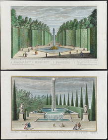
Demortain - 4 Fountain & Garden EngravingsTrillium Antique Prints & Rare Books4.5(30)See Sold PriceFeb 24, 2024
Pablo Picasso & Jean Cocteau's Picasso de 1916 ? 1961 - 24 LithographsTrillium Antique Prints & Rare Books4.5(30)See Sold PriceFeb 24, 2024
Kipling's Les plus beaux contes - 24 Engravings by Kees Van DongenTrillium Antique Prints & Rare Books4.5(30)See Sold PriceFeb 24, 2024
First Copy of Gautier's Le Roman de la Momie - 13 Original Watercolors by George Barbier (2 VolumesTrillium Antique Prints & Rare Books4.5(30)See Sold PriceFeb 24, 2024
Pascal's Collection de fleurs... - Volume with 48 Originally Hand-colored LithographsTrillium Antique Prints & Rare Books4.5(30)See Sold PriceFeb 24, 2024
Karl Bodmer - Scalp Dance of the Minatarres. 27Trillium Antique Prints & Rare Books4.5(30)See Sold PriceFeb 24, 2024
1764 Bellin Map of Port Antonio, Jamaica -- Plan des Havres de Port Antonio et de Saint FrancoisJasper524.5(9.8k)See Sold PriceFeb 27, 2024
Henri-Joseph Redouté - Large Folio Botanical Print - Plants in Egypt - Fagonia latifoliaProverde Auctions4.3(3)See Sold PriceFeb 28, 2024
Antique Map of Poland, 1700 by Guillaume De Lisle, ParisAntiques Online Auctions4.6(407)See Sold PriceMar 14, 2024