MAP - PIETER SCHENK / VALK / JANSSEN Hand Colored superb Map Central Italy c1702Luis Porretta Fine Arts4.3(10)See Sold PriceMar 02, 2024
CHARLES ROLLIN c1828 Ceasar Hand Colored Africa Military MapLuis Porretta Fine Arts4.3(10)See Sold PriceMar 02, 2024
MAP - Dufour, A. H. ( Malte / Brun ) :MAP - ESPAGNE PARTIE SUD DIVISEE EN PROVINCES ANCIENNES ( MAPLuis Porretta Fine Arts4.3(10)See Sold PriceMar 02, 2024
RIGOBERT BONNE c1787 Original Colored Map Germany & Region 15" x 12"Luis Porretta Fine Arts4.3(10)See Sold PriceMar 02, 2024
AMBROISE TARDIEU c1822 Napoleonic War Map GermanyLuis Porretta Fine Arts4.3(10)See Sold PriceMar 02, 2024
MAP - AMBROISE TARDIEU c1822 Napoleonic Miltary Map GermanyLuis Porretta Fine Arts4.3(10)See Sold PriceMar 02, 2024
1822 Rare Map by Ambroise Tardieu Napoleon Caldiero Battle of Vento 17" x 11Luis Porretta Fine Arts4.3(10)See Sold PriceMar 02, 2024
PIETER SCHENK / VALK / JANSSEN Hand Colored Map of Rhodes Greece ca1702 vgcLuis Porretta Fine Arts4.3(10)See Sold PriceMar 02, 2024
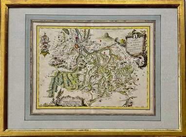
Map: Carte du Canton de Bale, Jacques Clermont, Paris, 1788Kensington Estate Auction4.6(216)See Sold PriceFeb 26, 2024
De Fer Map showing California as an IslandDE FER, Nicholas (1646-1720). La Californie ou Nouvelle Caroline... Engraved map with original color in outline. Paris, 1720. 18 1/2" x 26 1/2" visible, 28" x 36" framed. An impressive map depicting CSee Sold Price
SoldMap showing California as an Island dated 1717 byMap showing California as an Island dated 1717 by Nicolas Defer, approx 10" x 14".See Sold Price
SoldDe Fer Map of California as an IslandDe Fer, Nicholas (1646-1720). La Californie ou Nouvelle Caroline... Engraved map. Paris, 1720. 19" x 27" visible, 28 1/2" x 36 1/2" framed. Hard to find this stunning map of Califronia as an Island. TSee Sold Price
SoldHand-Colored 1727 Map: California As An IslandHistoric MapsHand-Colored 1727 Map With California As An Island" 1727, Hand-Colored Map of The Americas, by Nicholas de Fer and engraved by H. Van Loon, with California as an Island, and the MississipSee Sold Price
De Fer world map with insular California 1714Title: Mappe-Monde ou Carte Universelle par N. de Fer Author: De Fer, Nicolas Description: Copper-engraved map. Engraved by C. Inselin. 22.5x33.5 cm. (9x13¼").World map with California an island. TheSee Sold Price
SoldKino map with California an islandHeading: Author: De Fer, Nicolas Title: Cette Carte de Californie et du Nouveau Mexique, est tirée de celle qui a èté envoyée par un grande d'Espagne pour ètre communiquée a Mrs. de l'AcademieSee Sold Price
SoldDe Fer world map with insular California 1714Title: Mappe-Monde ou Carte Universelle par N. de Fer Author: De Fer, Nicolas Description: Copper-engraved map. Engraved by C. Inselin. 22.5x33.5 cm. (9x13¼").World map with California an island. TheSee Sold Price
SoldKino map with California an islandHeading: Author: De Fer, Nicolas Title: Cette Carte de Californie et du Nouveau Mexique, est tirée de celle qui a èté envoyée par un grande d'Espagne pour ètre communiquée a Mrs. de l'AcademieSee Sold Price
SoldNicolas De Fer: Carte Generale du Globe Terrestre, 1705Map: Carte Generale du Globe Terrestre et Aquatiques ou Mappemonde en Deux Plans-Hemisphere [Scarce 1705 antique map with California as an island] Maker: Nicolas De Fer Size: 8.125 x 11.125 (10.25 x 1See Sold Price
SoldDe Fer's map of America with California an IslandTitle: L'Amerique, Meridionale et Septentrionale Dressee selon les Dernieres Relations et Suivant les Nouvelles Decouvertes... Author: De Fer, Nicolas Description: Copper-engraved map. 22.7x33.5 cm. (See Sold Price
SoldFrench Map of Island of California & History, 1700Nicolas De Fer (French, 1646 to 1720) / Charles Inselin (French, 1673 to 1715), printed in the 19th century CE, first created in 1700 CE. A fun pair of black prints on laid paper; a map of the "IslandSee Sold Price
SoldWIT, FREDERICK de. Novissima et Accuratissima TotiusWIT, FREDERICK de. Novissima et Accuratissima Totius Americae Descriptio. Double-page engraved map of the Americas showing California as an island. 20x23½ inches sheet size, ample margins; originSee Sold Price
Sold1705 Map: L-AMERIQUE [AMERICA] by N. de FerHistoric MapsMap of "L'Amerique" with California as an Island 1705, "L'AMERIQUE, MERIDIONALE, ET SEPTENTRIONALE," by N. de Fer, Paris, Very Fine. This excellent and highly detaSee Sold Price
SoldNorth and South America with California an island 1700Heading: Author: De Fer, Nicolas Title: L'Amerique, Meridionale et Septentrionale Dressee selon les Dernieres Relations et Suivant les Nouvelles Decouvertes... Place Published: Paris Publisher:See Sold Price
SoldSanson (Nicolas) - Audience de Guadalajara, Nouveaushowing California as an island, with Mexico lower right, engraved map, with outline hand-colouring in yellow, 210 x 245 mm., central vertical fold, wide margins, minor spotting and browning, four orSee Sold Price
SoldDe Fer Map of California, 1720DE FER, Nicholas (1646-1720). La Californie ou Nouvelle Caroline, teatro de los trabajos, apostolicos de la campa e Jesus en la America… Engraved map with original color in outline. Paris, 1720.See Sold Price
SoldDe Fer Engraved Map of CaliforniaLa Californie ou Nouvelle Caroline, teatro de los trabajos, apostolicos de la campa e Jesus en la America...Nicholas de Fer (1646-1720). Engraved map. Paris, 1720. 19 x 27 inches visible, 28 1/2 x 36See Sold Price
Sold1740 America Map Showing California As An IslandHistoric Maps c. 1740 Beautiful Map Showing California As An Island! A MAP OF NORTH AMERICA... by R.W. Seale, London c. 1740, Historic Hand-Colored Map titled, “A MAP OF NORTH AMERICA WITH THE EUROPSee Sold Price
SoldRare Mexican map showing California not an islandHeading: Author: Castillo, Domingo del. Title: [Nautical chart of the Pacific coast of Mexico, Baja California, and the Gulf of California] Place Published: Mexico Publisher:[Impr. del Superior GobieSee Sold Price
Senex's World Map Showing California as an IslandSenex’s World Map Showing California as an Island With Text by Isaac Newton & Edmond Halley 361. See Sold Price
SoldKino map showing California not an islandHeading: Author: Kino, Eusebio Francisco Title: A Passage by Land to California Discover'd by Father Eusebius Francis Kino a Jesuit between ye years 1698 and 1701... Place Published: London PublisherSee Sold Price
SoldWith world map showing California as an island, 1705Heading: Author: Halley, Edmond, editor Title: Miscellanea Curiosa. Being a collection of some of the principal phaenomena in nature, accounted for by the greatest philosophers of this age. TogetherSee Sold Price
De Fer California MapDe Fer, Nicholas (1646-1720). La Californie ou Nouvelle Caroline... Engraved map with original color in outline. Paris, 1720. 18 1/2" x 26 1/2" visible, 28" x 36" framed. An impressive map depicting CSee Sold Price
Sold[Map]. Small Map Showing California as an Island. Large[Map]. Small Map Showing California as an Island. Large sheet from an unknown almanac orSee Sold Price
EARLY 18TH C. DUTCH CHART OF PACIFIC OCEAN BY FREDERIK DE WIT (1629-1706) WITH CALIFORNIA AS ANThomaston Place Auction Galleries4.4(386)See Sold PriceFeb 24, 2024
CHARLES ROLLIN c1828 Ceasar Hand Colored Africa Military MapLuis Porretta Fine Arts4.3(10)See Sold PriceMar 02, 2024
Italian edition of Sanson's map of North America, 1677PBA Galleries4.7(381)See Sold PriceMar 07, 2024
COLONIAL GABON & CONGO. Afrique équatoriale française. Brazzaville plan 1929 mapJasper524.5(9.8k)See Sold PriceFeb 28, 2024
COLONIAL GABON & CONGO. Afrique équatoriale française. Brazzaville plan 1938 mapJasper524.5(9.8k)See Sold PriceFeb 28, 2024
Chemins De Fer Belges - Art By Van Doren (1928) Belgian Advertising Poster LBJasper524.5(9.8k)See Sold PriceFeb 28, 2024


![1705 Map: L-AMERIQUE [AMERICA] by N. de Fer (1 of 4)](https://p1.liveauctioneers.com/218/16690/5553153_1_x.jpg?height=282&quality=70&version=1218659325)


![[Map]. Small Map Showing California as an Island. Large (1 of 2)](https://p1.liveauctioneers.com/906/21743/7489549_1_x.jpg?height=282&quality=70)


