Ink on paper Ernst Ludwig Kirchner after Expressionist German dancing womenVintage Art Finder Gallery4.2(4)See Sold PriceApr 07, 2024
Pastel on paper Hans Hartung after French German Abstract drawingVintage Art Finder Gallery4.2(4)See Sold PriceApr 07, 2024
Franz Marc after German Expressionist drawing on paper geometric abstractionVintage Art Finder Gallery4.2(4)See Sold PriceApr 07, 2024
Max Pechstein style of German Expressionist ink on paper nude womanVintage Art Finder Gallery4.2(4)See Sold PriceApr 07, 2024
SoldD-DAY MAP OF ALL LANDING BEACHES WITH KEY TO GERMAN GUND-DAY MAP OF ALL LANDING BEACHES WITH KEY TO GERMAN GUN EMPLACEMENTS Historically important pairing of items including a pre-invasion printed map with plots of all of the OVERLORD landing beaches, asSee Sold Price
SoldGERMAN HELMET RECOVERED AT UTAH BEACHA fine D-Day landing beach relic, a German M42 helmet recovered along the strand at Utah Beach by a Dutch collector and 'digger' in 1986 and bearing his cardboard identification tag. The helmet was liSee Sold Price
SoldWW II D-Day Invasion Map29 1/2" x 43 1/2" sight with German gun emplacements and ranges labeled Top Secret upper right dated April 14, 1944 lower rightSee Sold Price
SoldMAP OF FALAISE AND BRITISH D-DAY LANDING BEACHESMAP OF FALAISE AND BRITISH D-DAY LANDING BEACHES British military map: "CAEN-FALAISE SHEET 7f", 31" x 38", issued by the War Office, 1943. The British D-Day landing zones about Ouistreham are shown inSee Sold Price
SoldUTAH BEACH SOUTH - INVASION MAP OF LANDING CRAFT ANDUTAH BEACH SOUTH - INVASION MAP OF LANDING CRAFT AND BEACH DEFENSES Highly important and historical map intended for use in the D-Day invasion of France in Normandy. The map, titled "UTAH BEACH-SOUTHSee Sold Price
SoldCLARENCE R. HUEBNER(1888 - 1972) American general commanded the 1st Infantry Division during and after the D-Day landings on June 6 1944 where it was the first force to face the Germans on Omaha Beach and he joined hisSee Sold Price
CLARENCE R. HUEBNER(1888-1972) American general, commanded the 1st Infantry Division during and after the D-Day landings on June 6, 1944, where it was the first force to face the Germans on Omaha Beach, and he joined hiSee Sold Price
SoldCLARENCE R. HUEBNER(1888-1972) American general commanded the 1st Infantry Division during and after the D-Day landings on June 6 1944 where it was the first force to face the Germans on Omaha Beach and he joined his meSee Sold Price
SoldCLARENCE R. HUEBNER RETIRES FROM THE AMERICAN ARMY(1888 - 1972) American general commanded the 1st Infantry Division during and after the D-Day landings on June 6 1944 where it was the first force to face the Germans on Omaha Beach and he joined hisSee Sold Price
SoldD-Day Invasion: Operation Bigot Omaha Beach Map.D-Day Invasion: August 1944 Allied Landing Map. 21.75" x 28.75" military map of beachheads in Provence, part of Operation Dragoon, mounted to board and housed in a simple inexpensive frame. Issued subSee Sold Price
SoldMAP OF GUN POSITIONS DEFENDING D-DAY BEACHESMAP OF GUN POSITIONS DEFENDING D-DAY BEACHES Excellent original 1:147,700-scale map, 43 ½" x 29 ½" (sight), published by the British Hydrographic Office of the Admiralty on March 15, 1944, and sSee Sold Price
IRON CROSS FRAGMENT FOUND ON A D-DAY BEACHAn excellent find, the beaded front frame from a German Iron Cross, discovered on an unidentified Normandy landing beach by a Dutch collector and 'digger' in the 1980s. The digger usually 'worked' aloSee Sold Price
SoldMAP TRACINGS USED FOR D-DAY LANDINGS AT UTAH AND OMAHAMAP TRACINGS USED FOR D-DAY LANDINGS AT UTAH AND OMAHA BEACHES Lot of four 13"" x 14"" pieces of tracing paper printed with late corrections to nautical maps showing fortifications obstacles etc. usedSee Sold Price
SoldMAP TRACINGS USED FOR D-DAY LANDINGS AT UTAH AND OMAHAMAP TRACINGS USED FOR D-DAY LANDINGS AT UTAH AND OMAHA BEACHES Lot of four 13"" x 14"" pieces of tracing paper printed with late corrections to nautical maps showing fortifications obstacles etc. usedSee Sold Price
SoldWWII TREASURY POSTER "INVSASION BOND" D-DAY THEME20" x 28" color poster depicting advancing GI's with thompson sub machine guns, P-51 aircraft, and Higgins boats landing on a beach under fire. Designed by R. Moore, printed by the US Treasury DepartmSee Sold Price
SoldMAP OF THE DEFENSES OF UTAH BEACH, FROM A COMBATMAP OF THE DEFENSES OF UTAH BEACH, FROM A COMBAT VETERAN WHO LANDED THERE A most important map showing the German defenses of the four landing zones comprising UTAH BEACH, northwest of St. Marie du MoSee Sold Price
DEFENSES MAP OF UTAH BEACH AT STE. MARIE DU MONTDEFENSES MAP OF UTAH BEACH AT STE. MARIE DU MONT A most important map showing the German defenses of the four landing zones comprising UTAH BEACH, northwest of St. Marie du Mont and just east of St.MaSee Sold Price
RNSC 6 11. Operation Neptune, D-Day, 6th June 1944RNSC 6 11. Operation Neptune, D-Day, 6th June 1944 Pre-Assault Royal Navy Bombardment. Cover design shows a map of the Navy approach and assault on the beaches. 50th Anniversary -D-Day Landings OperatSee Sold Price
Collection of Sixteen (16) Travel BooksIncludes "The Curse of the Dutchman's Gold", "The Beaches of the D-Day Landings", "Isles of the Caribbees", "Department of the Army Technical Manual: Map Reading", "Rocamadour Tourist Guide", "The FonSee Sold Price
SoldOMAHA BEACH INVASION PLANS AND MAP OVERLAYS, USED BY ANOMAHA BEACH INVASION PLANS AND MAP OVERLAYS, USED BY AN OFFICER WHO LANDED ON D-DAY Historic set of plans for OPERATION NEPTUNE, the D-Day landings in Normandy on June 6, 1944, this set specifically pSee Sold Price
SoldACCOUNT OF ANTI-AIRCRAFT BALLOONS USED ON D-DAYACCOUNT OF ANTI-AIRCRAFT BALLOONS USED ON D-DAY British officer’s account of anti-aircraft balloons used to protect British warships while en route to the D-Day landing beaches and during operaSee Sold Price
SoldWW2 US Bigot D-DAY Map, Omaha Beach West, 1944World War Two, US Bigot D-Day Map, Omaha Beach (1pc). A rare "TOP SECRET-BIGOT" Map of "Omaha Beach--West" (Vierville-sur-Mer) as prepared by Commander Task Force 122, April 1944. This map features whSee Sold Price
SoldWWII D-DAY MAP OMAHA BEACH SECTOR DOG & CHARLIEWWII D-DAY MAP OMAHA BEACH SECTOR DOG & CHARLIE From Rear Admiral George B.H. Stallings Archive; map of Omaha Beach, sectors Dog and Charlie. Rear Admiral George B.H. Stallings served in the Navy DepaSee Sold Price
Sold3 Vintage WWII Pacific Theater Intelligence MapsAvailable are these 3 Vintage WWII Pacific Theater Intelligence Maps. One is and Okinawa Invasion map, size 17.5" x 22". The second is a map showing landing beaches on Tarawa Atoll, size 18"See Sold Price
MAP OF SALZBURG BY GEORGE BRAUN & FRANS HOGENBURG. 1588Thomaston Place Auction Galleries4.4(394)See Sold PriceFeb 24, 2024
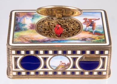
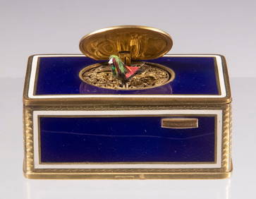
KARL GRIESBAUM ENAMELED SINGING BIRD BOXThomaston Place Auction Galleries4.4(394)See Sold PriceFeb 25, 2024
KARL GRIESBAUM GERMAN SINGING BIRD BOXThomaston Place Auction Galleries4.4(394)See Sold PriceFeb 25, 2024
Medieval Printed Paper Bible Page by Johann GrüningerTimeLine Auctions Ltd.4.6(184)See Sold PriceMar 07, 2024
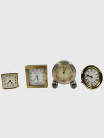
4 Pieces desk clocks (1) Van Cleef & Arpels wind up alarm clock, Swiss movement, 8 day, Swiss #179Neely Auction4.6(227)See Sold PriceFeb 25, 2024
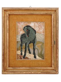
ITALIAN PIETRA DURA HORSE PICTURE AFTER FRANZ MARCAntique Arena Inc.4.5(883)See Sold PriceFeb 24, 2024
Group of 15 Printed or Lithographed Items, including: litho...Potter & Potter Auctions4.6(550)See Sold PriceMar 07, 2024
[WORLD WAR II – OKINAWA]. Okinawa Shima Western Beaches Top...Potter & Potter Auctions4.6(550)See Sold PriceMar 07, 2024
ANTIQUE GERMAN HEXAGONAL BRASS TABLE CLOCK WITH KEYAntique Arena Inc.4.5(883)See Sold PriceMar 02, 2024
Thomas Harland Sligh inlaid Grandfather ClockBroken Arch Auction Gallery NCFL#93994.6(301)See Sold PriceMar 04, 2024
Mathias Joseph Alten (German/American, 1871-1938) Oil on Canvas Ca. 1911, "St. Andreas Church,DuMouchelles4.6(833)See Sold PriceMar 15, 2024
Nancy Graves (American, 1939-1995) Lithograph in Colors on Arches Paper 1972, "Lunar Landscape V", HDuMouchelles4.6(833)See Sold PriceMar 15, 2024


![[WORLD WAR II – OKINAWA]. Okinawa Shima Western Beaches Top... (1 of 1)](https://p1.liveauctioneers.com/928/318880/171361141_1_x.jpg?height=282&quality=70&version=1707501302)