Complete System Universal Geography Christopher Ke"New and Complete System of Universal Geography" by Christopher Kelly. Volume I of a two volume set. London: Printed for Thomas Kelly, 1828. Hardcover, 774pp., quarto, leather boards, gilt stamping. DSee Sold Price
Complete System Universal Geography Christopher Ke"New and Complete System of Universal Geography" by Christopher Kelly. Volume I of a two volume set. London: Printed for Thomas Kelly, 1828. Hardcover, 774pp., quarto, leather boards, gilt stamping. DSee Sold Price
Complete System Universal Geography Christopher K''New and Complete System of Universal Geography'' by Christopher Kelly. Volume I of a two volume set. London: Printed for Thomas Kelly: 1828. Hardcover, 774pp., quarto with marbled endpapers and giltSee Sold Price
SoldRussia 1818-1835 Pair of Antique Maps"Russian Empire" Copper Engraved Map Published 1818, London for "A New and Complete System of Universal Geography" by Christopher Kelly. Together with "Russia in Europe Part V" Steel Engraved Map PublSee Sold Price
Book Complete Geography Christopher Kelly Volume''New and Complete System of Universal Geography'' by Christopher Kelly. Volume I of a two volume set. London: Printed for Thomas Kelly: 1828. Hardcover, 774pp., quarto with marbled endpapers and giltSee Sold Price
Book Complete Geography Christopher Kelly Volume I 1828''New and Complete System of Universal Geography'' by Christopher Kelly. Volume I of a two volume set. London: Printed for Thomas Kelly: 1828. Hardcover, 774pp., quarto with marbled endpapers and giltSee Sold Price
SoldKELLY (CHRISTOPHER) A NEW AND COMPLETE SYSTEM OFKELLY (Christopher) A New and Complete System of Universal Geography; Or, An Authentic History and Interesting Description of the Whole World...forming and Ornamental and Complete Atlas, 2 volumes, LoSee Sold Price
SoldThe State of Pennsylvania from the Latest Surveys, 1800The State of Pennsylvania from the Latest Surveys, 1800 Published by John Low, New York From John Payne's "A New and Complete System of Universal Geography," published circa 1802. Medium: Original copSee Sold Price
SoldEgypt C1790 Antique Print. Pyramids, Sphinx, NileCopper Plate Published C1790 London for "A New Royal Authentic and Complete System of Universal Geography Antient and Modern" by Thomas Bankes. Paper Size: 14.5 x 9 inch (37 x 23cm) Good ConditionSee Sold Price
SoldKentucky Map, 1800 Payne"The State of Kentucky with Adjoining Territories" Map, by John Payne, engraved by John Scoles, published by John Low, New York, 1800. From "A New and Complete System of Universal Geography" by John PSee Sold Price
SoldVermont from the Latest Authorities, 1799Vermont from the Latest Authorities, 1799 From John Payne's "A New and Complete System of Universal Geography", published circa 1802. Medium: Original copper engraved map Plate size: 9 inches high x 7See Sold Price
SoldMap; The State of Pennsylvania, 1800.Map; The State of Pennsylvania from the Latest Surveys 1800. Published by J. Low, NYork. This map is from John Payne's A New and Complete System of Universal Geography, published c1798-1800 per ListerSee Sold Price
SoldThree Maps of PennsylvaniaThree Maps of Pennsylvania Including, PAYNE, John. The State of Pennsylvania from the Latest Surveys 1800. New York, 1800. From Payne's New & Complete System of Universal Geography, one of the earSee Sold Price
SoldBankes, Thomas C1790 Folio Print. Alaska, USA"View of Oonalashka…" Copper Plate Published C1790 London for "A New Royal Authentic and Complete System of Universal Geography Antient and Modern" by Thomas Bankes. Paper Size: 14.5 x 9.5 inch (37See Sold Price
SoldBANKES (Rev. Thomas) A New Royal Authentic and CompleteBANKES (Rev. Thomas) A New Royal Authentic and Complete System of Universal Geography. London: for J. Cooke no date, c.1790, folio, frontispiece, plates and 22 maps and charts including folding, as reSee Sold Price
SoldBankes, Thomas C1790 Folio Print. View of Alaska USA"View of Oonalashka, and the inhabitans, &c" Copper Plate Published C1790 London for "A New Royal Authentic and Complete System of Universal Geography Antient and Modern" by Thomas Bankes. Paper Size:See Sold Price
Payne's Geography Book IV, 1799New and Complete System of Universal Geography Describing Asia, Africa, Europe, and America; Book IV, by John Payne. Printed and sold by John Low, New York, 1799. 525 pages plus tables. Leather boundSee Sold Price
SoldPayne's Geography with maps of U.S. states 1798-1800Heading: Author: Payne, John Title: New and Complete System of Universal Geography; Describing Asia, Africa, Europe and America... Place Published: New York Publisher:John Low Date Published: </See Sold Price
SoldKelly's Universal Geography 1817Heading: Author: Kelly, Christopher Title: A New And Complete System Of Universal Geography, Or, An Authentic History And Interesting Description Of The Whole World And Its Inhabitants... Place PubliSee Sold Price
World.- Bankes (Rev. Thomas) A New Royal Authentic andWorld.- Bankes (Rev.Thomas), E.W.Blake and Alexander Cook. A New Royal Authentic and Complete System of Universal Geography Ancient and Modern, engraved allegorical frontispiece and 88 plates (many wiSee Sold Price
Two volumes ' Kelly's New System of Universal GeographyTwo volumes ' Kelly's New System of Universal Geography ' by Christopher Kelly, London 1814, in gilt tooled leather bindings (lacking maps and plates) together with a 19th Century leather bound book,See Sold Price
SoldThomas Kitchin, A New Map of China. 1782Thomas Kitchin, A New Map of China made by order of the Emperor. London, 1782. Published in George H. Millar's 'New Complete & Universal System of Geography'. Impression measures 13.5x15.25'' on 14.5xSee Sold Price
SoldMiller, George 1782 HC Print. Brazil Natives & St.Hand Colored Copper Plate Published 1782 London for "Millar's New Complete & Universal System of Geography" by George Henry Millar. Paper Size: 14 x 9 inch (36 x 23cm) Approx. Minor text offsetting inSee Sold Price
SoldMiller, George 1782 Copper Engraving of Paris, FranceCopper Plate Published 1782 London for "Millar's New Complete & Universal System of Geography" by George Henry Millar. Paper Size: 15 x 9.5 inch (38 x 24cm) Good ConditionSee Sold Price
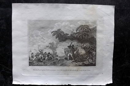
Cooke, George 1801 Print. Death of Captain Cook at Hawaii USAAlbion Auctions4.6(341)See Sold PriceMar 07, 2024
Cooke, George 1801 Print. Kaneena, Chief of the Sandwich Islands. HawaiiAlbion Auctions4.6(341)See Sold PriceMar 07, 2024
Cooke, George 1801 Print. Maori Tattoo Man, Warrior of New ZealandAlbion Auctions4.6(341)See Sold PriceMar 07, 2024
Cooke, George 1801 Print. Natives of Tahiti attacking Capt. WallisAlbion Auctions4.6(341)See Sold PriceMar 07, 2024
Cooke, George 1801 Print. Papua New Guinea Man hunting Wild HogsAlbion Auctions4.6(341)See Sold PriceMar 07, 2024
Cooke, George 1801 Print. Savage of New Caledonia, PacificAlbion Auctions4.6(341)See Sold PriceMar 07, 2024
Cooke, George 1801 Print. Savage of Nootka Sound, CanadaAlbion Auctions4.6(341)See Sold PriceMar 07, 2024
Cooke, George 1801 Print. Savage of Price William Sound, AlaskaAlbion Auctions4.6(341)See Sold PriceMar 07, 2024
Cooke, George 1801 Print. Woman of the Sandwich Islands. HawaiiAlbion Auctions4.6(341)See Sold PriceMar 07, 2024
Cooke, George 1801 Antique Map. United States of AmericaAlbion Auctions4.6(341)See Sold PriceMar 01, 2024
Cooke, George 1801 Antique Map. West Indies CaribbeanAlbion Auctions4.6(341)See Sold PriceMar 01, 2024
Cooke, George 1801 Antique Map. Germany divided into CirclesAlbion Auctions4.6(341)See Sold PriceMar 01, 2024
Cooke, George 1801 Antique Map. Italy, Sicily, Sardinia & CorsicaAlbion Auctions4.6(341)See Sold PriceMar 01, 2024