SoldNEW CENTURY ATLAS OF COUNTIES OF THE STATE OF NEW YORK,NEW CENTURY ATLAS OF COUNTIES OF THE STATE OF NEW YORK, EVENTS PUB. CO., 1912; (42) COLORED MAPS. 26 X 20" (IMPERFECTIONS)See Sold Price
(9) Assorted 19th Century Maps w/ Hand ColoringCollection of nine (9) assorted 19th Century maps with hand coloring, New York Lithograph engraving and printing Company, 16 Park Place, New York, New York. Including: Italia, Roma, Assyria, Empire ofSee Sold Price
SoldGrp: 9 Maps of New York City 18th-Early 20th c.Group of nine maps of New York City, dating from the 18th to early 20th century. By cartographers including John Montresor (1736-1799). Additionally includes a lovely 1704 map of the city featuring thSee Sold Price
SoldEarly Map of New HavenEarly map of New Haven. 19th century frame. Frame size: H 18", W 20-1/2". Collection of Laura Mitler. Please see link for high res photos: https://www.dropbox.com/sh/dyyxg1niyhdxg4j/AABXxW62_-x5i3adK3See Sold Price
SoldAN ANTIQUE MAP, "Southern States, Western Section,"AN ANTIQUE MAP, "Southern States, Western Section," EARLY/MID 20TH CENTURY, color ink on paper, "Mathews, Northup & Co...Buffalo, N.Y.," with map of New Orleans and Vicinity. 9.25" x 11.50"See Sold Price
Sold19th Century Map - A Plan of the Town, New HavenMap of plan of New Haven. Paper in linen. 19th century. Map opening size : H 7-3/4", W 6"; frame size: H 14", W 12". Excellent condition. Professionally framed. Collection of Laura Mitler. Please refeSee Sold Price
SoldFRENCH & AMERICAN PRINTED MAPS 19TH C.-20TH C. 3PCFRENCH & AMERICAN PRINTED MAPS, 19TH C.-20TH C., THREE, H 9 1/4"-14", W 9 1/2"-12 1/2":Including one French map of New Holland, measuring H. 14" x 9 3/4", circa late 19th Century; together with one maSee Sold Price
SoldCollection of 19th Century mapsVarious engravers and publishers including Augustus Mitchell A.J. Johnson New York, Taintor Bros & Merrill are a few. See photos for details. Fair to good condition as shown. Also a great 1832 by BaldSee Sold Price
SoldDelamarche: New Spain, New Mexico, West IndiesCartographer: Delamarche Place & Date: Paris / 1812 Size: 14 3/4" x 9 3/4" Condition: outline color; overall age toning; minor spotting, mostly in margins An early 19th-century depiction of the SpanisSee Sold Price
SoldNine (9) Augustus Mitchell MapsCollection of late 19th century United States STATE maps including Minnesota, Iowa and Missouri, State of Maine , Illinois-Missouri-Iowa-Nebraska-and Kansas on one, Two Georgia and Alabama, ConnecticuSee Sold Price
Sold[CANADA & NORTH AMERICA] A collection of 13 maps[CANADA & NORTH AMERICA] A collection of 13 engraved maps. Early 19th century. Various dimensions (approx. 30 x 25 cm). Various conditions. Includes: Northern Hemisphere, Illman & Pilbrow. New York. *See Sold Price
SoldCollection of Twelve Maps and Charts, 18th-19th centuryincludes: The World, a small double hemisphere map showing Cook's voyages; Ea-hei-no-maue, North Island, New Zealand (1798, rare); The Coti River, in Borneo; Map of Yucatan; Map of Siam and Cochin ChiSee Sold Price
Millar: Antique Map of Hanover, 1768Title/Content of Map: 1768 Millar Map of Hanover -- A New Correct Plan of Hanover Date Printed: 1768 c. Cartographer: G Millar Size: 14.3 x 9.3 in. A very interesting and rather rare 18th century planSee Sold Price
Sold1897 Alabama map. The Century Atlas, New York. 11 31897 Alabama map. The Century Atlas, New York. 11 3/4" x 16"See Sold Price
SoldChinese Celadon Jade Wine EwerWith crab motif in two tone colors. 19th century. From a New York collection. 9" WSee Sold Price
SoldBay Area Embossed Soda Bottle Collection, 9 [168820]Bay Area embossed bottles. Hutch-2x W Twomey/Vallejo, New Century Steam/San Francisco, Klammer & Malz/San Rafael. Crowntop-A N M W/Martinez, Haywards Soda Works, Enterprise Soda Works/San Francisco. RSee Sold Price
SoldNew Century Atlas of Lake County Ohio''New Century Atlas of Lake County Ohio'', Alexander C. Stark, Chief Engineer, Century Map Co., Philadelphia, 1915, 127pp containing 29 maps and 14 pgs of test, atlas folio (17 1/2 x 24''), hard boundSee Sold Price
SoldNew Century Atlas of Montgomery and Fulton Counties, NYNew century atlas of Montgomery and Fulton counties, NY C. 1890's with many maps in color of all surrounding towns. Binding separated. 18" wide, 21" tall.See Sold Price
Sold1904 NEW CENTURY ATLAS CAYUGA CO. NY FARMS.1904 NEW CENTURY ATLAS CAYUGA CO. NY FARMS. 137 PGS OF HAND COLORED MAPS INCL. PORTRAIT GALLERIES, VIEWS, BUSINESS DIRECTORIES AND FARM HISTORIES. PAPER/CLOTH MAPS. REBOUND ORIG. PGS. IN NEW MAROON CLSee Sold Price
Sold1904 NEW CENTURY ATLAS OF WAYNE CO. NY FARMS.1904 NEW CENTURY ATLAS OF WAYNE CO. NY FARMS. 90 PGS INCL. HAND COLORED MAPS, BUSINESS DIRECTORIES, VALUABLE FARMS, 1 BLACK & WHITE PLATE OF 4 PHOTOS OF FARMS. PUBLISHED BY CENTURY MAP CO., PHIL. 1904See Sold Price
SoldNEW CENTURY ATLAS STATE OF NEW YORK, 1911 LARGE BONEW CENTURY ATLAS STATE OF NEW YORK, 1911 LARGE BOOK, INCLUDES MAP OF THE STATE AND COUNTIES, ADVERTISEMENTS FROM BUSINESSES IN WESTCHESTER AND ROCKLAND COUNTIES,AND ILLUSTRATIONS, COVER IS TORN AND LSee Sold Price
Sold(2) Fenton New Century Collection(1) 9.5" Fenton "New Century Collection, turquoise blue, pitcher. In rib optic pattern, with a heart shaped mouth. Ribbed twist handle. Hand painted design. Excellent condition, signed on base. (1) NeSee Sold Price
SoldPair Antique 19th Century Atlases, Bound MapsPair Antique 19th Century Atlases. ‘Mitchell’s New General Atlas Containing Maps of Various Countries of the World, Plans of Cities, Etc.’ published by S. Augustus Mitchell, Jr. c 1860. ‘AtlasSee Sold Price
SoldPair Antique 19th Century Atlases, Bound MapsPair Antique 19th Century Atlases. ‘Mitchell’s New General Atlas Containing Maps of Various Countries of the World, Plans of Cities, Etc.’ published by S. Augustus Mitchell, Jr. c 1860. ‘AtlasSee Sold Price
Gordon Redmond 20C Purple Coral Art Glass 12" VaseHill Auction Gallery 4.7(1k)See Sold PriceFeb 28, 2024
Mitchell - Map of the City of Washington (Washington, DC)Trillium Antique Prints & Rare Books4.5(32)See Sold PriceFeb 24, 2024
EDWARD MORAN (1829-1901) "LAKESIDE LANDSCAPE".Amelia Jeffers, Auctioneers & Appraisers4.5(120)See Sold PriceMar 07, 2024
EDWARD HENRY POTTHAST (1857-1927) "VETERANS".Amelia Jeffers, Auctioneers & Appraisers4.5(120)See Sold PriceMar 07, 2024
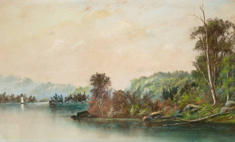
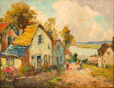
GIFFORD BEAL (1879-1956) "VILLAGE LANDSCAPE".Amelia Jeffers, Auctioneers & Appraisers4.5(120)See Sold PriceMar 07, 2024
AFTER GEORGE BENJAMIN LUKS (1867-1933) "NOCTURN".Amelia Jeffers, Auctioneers & Appraisers4.5(120)See Sold PriceMar 07, 2024
AFTER JOHN FRENCH SLOAN (1871-1951) "PORTRAIT OF AN OLDER MAN".Amelia Jeffers, Auctioneers & Appraisers4.5(120)See Sold PriceMar 07, 2024
AFTER ROBERT (HENRY COZAD) HENRI (1865-1929) "PORTRAIT OF A SEATED BOY".Amelia Jeffers, Auctioneers & Appraisers4.5(120)See Sold PriceMar 07, 2024
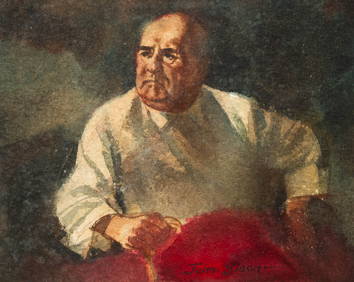
EDMUND CHARLES TARBELL (1862-1938) "EMELINA AND JOSE".Amelia Jeffers, Auctioneers & Appraisers4.5(120)See Sold PriceMar 07, 2024
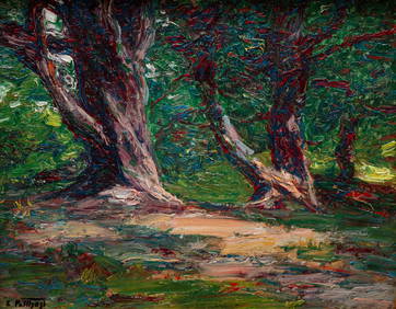
WILLIAM RUSSELL WHITMORE (1861-1917) "LANDSCAPE".Amelia Jeffers, Auctioneers & Appraisers4.5(120)See Sold PriceMar 07, 2024
1816 MAP SOUTHERN PART OF RUSSIA or MUSCOVY in EUROPE copper engraving ANTIQUEJasper524.5(9.9k)See Sold PriceFeb 27, 2024
1816 MAP NORTHERN PART OF RUSSIA or MUSCOVY in EUROPE copper engraving ANTIQUEJasper524.5(9.9k)See Sold PriceFeb 27, 2024
Afrique Ancienne. Ancient North Africa. MALTE-BRUN c1871 old antique map chartJasper524.5(9.9k)See Sold PriceFeb 28, 2024
Two Hand-Colored 19th Century Maps of New Orleans and Louisiana, Larger- H.- 12 1/2 in., W.- 15 1/2Crescent City Auction Gallery4.3(231)See Sold PriceMar 08, 2024
3PC Police Documents & Photograph EphemeraBruneau & Co. Auctioneers4.5(491)See Sold PriceMar 18, 2024
16 Sotheby's New York & London Catalogs, 1990-1999Artemis Fine Arts4.8(1.4k)See Sold PriceMar 01, 2024


![[CANADA & NORTH AMERICA] A collection of 13 maps (1 of 2)](https://p1.liveauctioneers.com/1124/187577/94368854_1_x.jpg?height=282&quality=70&version=1607095126)


![Bay Area Embossed Soda Bottle Collection, 9 [168820] (1 of 3)](https://p1.liveauctioneers.com/2699/299100/159223703_1_x.jpg?height=282&quality=70&version=1692048031)