SoldCollection of [7] ancient geographic maps -EngravingsSoria Et Diarbeck, seven ancient geographic maps of Syria, one hand painted after printing. Average size: 19x26 cm. Overall fine condition.See Sold Price
SoldCollection of [7] ancient geographic maps. Asia and* Mesopotamia, Syria, Arabia Petera AC Deserta. Syria, Turkey the Arabian Dsert. 34x45 cm. * Turcici Imperii Imago. Engraving hand painted soon after it was printed. Arabian Peninsula, Turkey, Syria aSee Sold Price
SoldFive ancient geographic maps-Engravings. Europe, AsiaFive geographical maps - Europe, Asia and North Africa. *Â Carte Geographique du Monde Ancien, 1721. Asia, Europe and North Africa, 33x45 cm. *Â Carta Nuova Del Dominio, e stati del Turco Nell EurSee Sold Price
SoldA collection [7] of Ancient Maps of the Land of IsraelEarly geographical maps from various publishers. Some of the maps show the division into tribes. Three maps are painted by hand from the time of printing, and four are black and white. Two large maSee Sold Price
Collection of [9] ancient geographic maps. Asia, Holy* Orbis Romani Pars Orientalis. Large map, hand painted during the era of printing, includes Turkey, the Black Sea, the Holy Land and Egypt. 18th century. 55x70 cm. * Yabula Prima Gua Totius OrbSee Sold Price
SoldA Collection [7] of Maps and Engravings on the Topic of* Campo Dege Israeliti. An engraving of the Tabernacle including the symbols of the tribes, the tribes' camping places around the Tabernacle, and the census of each tribe. Size: 34x22 cm. * Rama.See Sold Price
SoldCollection of [6] ancient maps of the Holy Land, with* Rtibvs Ephraim Beniamin Et, Dan. Ancient geographic map, according to the plots of Ephraim, Benjamin and Dan. Latin captions. 17th century. 40x49 cm. *Â Mare Magnum...Canaan under Filios. Israel.See Sold Price
SoldCollection of [9] antique, colored maps of Palestine.Nine ancient geographic maps of Palestine. All hand-painted at the time of printing. Some have nice cartouches of the kings of Judah and the Temple Mount. Various printings: W. Hungar, E.A. Hancock, DSee Sold Price
MAPS IN BOOK, Atlases, TardieuAtlases. Ambroise Tardieu, Atlas Universel de Geographie Ancienne et Moderne, 1842 (published). Hand Color. This nearly complete atlas (26 of 27 maps) consists of 7 ancient maps and 19 (of 20) modernSee Sold Price
MAPS IN BOOK, Atlases, TardieuAtlases. Ambroise Tardieu, Atlas Universel de Geographie Ancienne et Moderne, 1842 (published). Hand Color. This nearly complete atlas (26 of 27 maps) consists of 7 ancient maps and 19 (of 20) modernSee Sold Price
SoldMoll, Hermann Sammlung von 36 Kupferstichen aus: AtlasMoll, Hermann Collection with 36 copper engravings. The collection represents beautiful geographic maps with rare maps of Persia, North Pole, Japan and China, Peru, Mexico, Barbados, Great Tartary, JaSee Sold Price
7 ENGRAVINGS ANCIENT GREECE7 Rare Engravings Ancient Greece . Size: 7 X 10 inches approx. Engravings are Unframed. Printed Ca 1881. German Text.See Sold Price
7 ENGRAVINGS ANCIENT GREECE7 Rare Engravings Ancient Greece . Size: 7 X 10 inches approx. Engravings are Unframed. Printed Ca 1881. German Text.See Sold Price
7 ENGRAVINGS ANCIENT GREECE7 Rare Engravings Ancient Greece . Size: 7 X 10 inches approx. Engravings are Unframed. Printed Ca 1881. German Text.See Sold Price
7 ENGRAVINGS ANCIENT GREECE7 Rare Engravings Ancient Greece . Size: 7 X 10 inches approx. Engravings are Unframed. Printed Ca 1881. German Text.See Sold Price
7 ENGRAVINGS ANCIENT GREECE7 Rare Engravings Ancient Greece . Size: 7 X 10 inches approx. Engravings are Unframed. Printed Ca 1881. German Text.See Sold Price
Sold27 Kupferstiche aus: Atlas élémentaire, datiert 1795.Collection with 27 copper engravings from "Atlas élémentaire", dated 1795. - The collection represents beautiful geographic maps with rare maps of Asia, Siberia, the Molucca islands and Nubian natioSee Sold Price
Collection of [6] antiquated geographic maps. Southern*Â Carte de la Terre de Chanaan. Engraving, hand painted soon after printing. Egypt, Sinai and southern Palestine. 23x29 cm. *Â Histoire Sainte. Engraving, hand painted soon after printing. Egypt,See Sold Price
SoldCollection of Jerusalem Maps. [27]. 15-19th Century.Unique collection of 27 maps of ancient and modern Jerusalem and the Holy Temple. Black and white engravings. 15-19th century. A collector lovingly collected these maps for decades. * Plan of JerusaleSee Sold Price
2 ENGRAVINGS ANCIENT GREECE THE PARTHENON2 Rare Engravings of The Parthenon. Size: 26.7 X 10 inches approx & 25 X 10 inches approx. Engravings are Unframed. Printed Ca 1881. Folded as issuedSee Sold Price
2 ENGRAVINGS ANCIENT GREECE THE PARTHENON2 Rare Engravings of The Parthenon. Size: 26.7 X 10 inches approx & 25 X 10 inches approx. Engravings are Unframed. Printed Ca 1881. Folded as issuedSee Sold Price
2 ENGRAVINGS ANCIENT GREECE THE PARTHENON2 Rare Engravings of The Parthenon. Size: 26.7 X 10 inches approx & 25 X 10 inches approx. Engravings are Unframed. Printed Ca 1881. Folded as issuedSee Sold Price
2 ENGRAVINGS ANCIENT GREECE THE PARTHENON2 Rare Engravings of The Parthenon. Size: 26.7 X 10 inches approx & 25 X 10 inches approx. Engravings are Unframed. Printed Ca 1881. Folded as issuedSee Sold Price
2 ENGRAVINGS ANCIENT GREECE THE PARTHENON2 Rare Engravings of The Parthenon. Size: 26.7 X 10 inches approx & 25 X 10 inches approx. Engravings are Unframed. Printed Ca 1881. Folded as issuedSee Sold Price
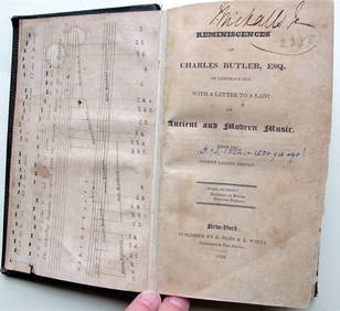
Charles Butler Ancient & Modern Music 1824 1st Edition Scarce MusicLuis Porretta Fine Arts4.3(10)See Sold PriceMar 02, 2024
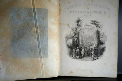
PAYNES UNIVERSUM ca1850 Calf 1st ed Travel 65 X Engravings China etc.Luis Porretta Fine Arts4.3(10)See Sold PriceMar 02, 2024
DEVINE c1856 Dr Salters Map Of Lake Huron Ontario Indian Lands etc. No. 7 ScarceLuis Porretta Fine Arts4.3(10)See Sold PriceMar 02, 2024
Japanese Woodblock c1950 Hand Colored Kegon Falls 10" x 7" SealedLuis Porretta Fine Arts4.3(10)See Sold PriceMar 02, 2024
Japanese Woodblock c1950 Valley Of Trees Hand Colored 10" x 7"Luis Porretta Fine Arts4.3(10)See Sold PriceMar 02, 2024
Neo Babylonian Agate Duck Weight with EngravingTimeLine Auctions Ltd.4.6(183)See Sold PriceMar 07, 2024
Hendrick Goltzius. 7 engravings. To include: several prints from "Allegories of the ChristianTremont Auctions4.5(297)See Sold PriceFeb 25, 2024
Hendrick Goltzius. 7 engravings by, after, and by the students of Goltzius. To include: History ofTremont Auctions4.5(297)See Sold PriceFeb 25, 2024
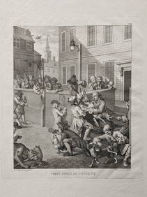
William Hogarth. 7 engravings by and after, including the Stages of Cruelty and The Times. Each mattTremont Auctions4.5(297)See Sold PriceFeb 25, 2024
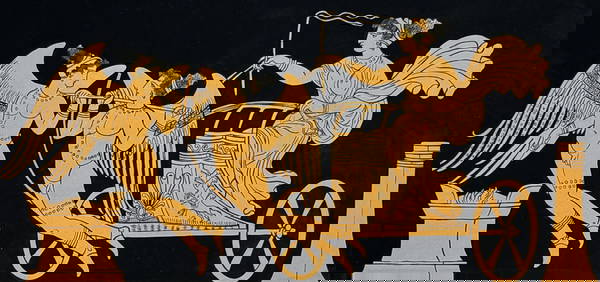
Hamilton - Engraving of a Painting from a Grecian Vase. 1Trillium Antique Prints & Rare Books4.5(32)See Sold PriceFeb 24, 2024
Hamilton - Engraving of a Painting from a Grecian VaseTrillium Antique Prints & Rare Books4.5(32)See Sold PriceFeb 24, 2024
Hamilton - Engraving of a Painting from a Grecian Vase. 2Trillium Antique Prints & Rare Books4.5(32)See Sold PriceFeb 24, 2024
Hamilton - Engraving of a Painting from a Grecian Vase. 32Trillium Antique Prints & Rare Books4.5(32)See Sold PriceFeb 24, 2024
Hamilton - Engraving of a Painting from a Grecian Vase. 114Trillium Antique Prints & Rare Books4.5(32)See Sold PriceFeb 24, 2024
Hamilton - Engraving of a Painting from a Grecian Vase. 5Trillium Antique Prints & Rare Books4.5(32)See Sold PriceFeb 24, 2024
1816 MAP SOUTHERN PART OF RUSSIA or MUSCOVY in EUROPE copper engraving ANTIQUEJasper524.5(9.9k)See Sold PriceFeb 27, 2024
1816 MAP NORTHERN PART OF RUSSIA or MUSCOVY in EUROPE copper engraving ANTIQUEJasper524.5(9.9k)See Sold PriceFeb 27, 2024
Nottingham.- Ordnance Survey Office (publisher) Collection 8 geological maps on the environs ofForum Auctions4.3(53)See Sold PriceFeb 29, 2024
Georg Bockler Map of Ancient Jerulsaem EtchingAuctions at Showplace4.6(740)See Sold PriceApr 07, 2024
Framed Collection Engravings & A Map From The Excursions In The County Of Sussex Published In 1822Rapid Estate Liquidators and Auction Gallery4.5(1.1k)See Sold PriceMar 01, 2024
![Collection of [7] ancient geographic maps -Engravings First Image](https://p1.liveauctioneers.com/2398/102367/52339682_1_x.jpg?height=282&quality=95&version=1491682802&width=282)
![Collection of [7] ancient geographic maps -Engravings (1 of 7)](https://p1.liveauctioneers.com/2398/102367/52339682_1_x.jpg?height=282&quality=70&version=1491682802)
![Collection of [7] ancient geographic maps -Engravings First Image](https://p1.liveauctioneers.com/2398/102367/52339682_1_x.jpg?height=282&quality=1&version=1491682802&width=282)
![Collection of [7] ancient geographic maps. Asia and (1 of 7)](https://p1.liveauctioneers.com/2398/98907/50388427_1_x.jpg?height=282&quality=70&version=1484078795)

![A collection [7] of Ancient Maps of the Land of Israel (1 of 7)](https://p1.liveauctioneers.com/2398/92630/47375540_1_x.jpg?height=282&quality=70&version=1471793846)
![Collection of [9] ancient geographic maps. Asia, Holy (1 of 9)](https://p1.liveauctioneers.com/2398/98907/50388420_1_x.jpg?height=282&quality=70&version=1484078795)
![A Collection [7] of Maps and Engravings on the Topic of (1 of 7)](https://p1.liveauctioneers.com/2398/106082/54328086_1_x.jpg?height=282&quality=70&version=1499076176)
![Collection of [6] ancient maps of the Holy Land, with (1 of 6)](https://p1.liveauctioneers.com/2398/98907/50388424_1_x.jpg?height=282&quality=70&version=1484078795)
![Collection of [9] antique, colored maps of Palestine. (1 of 9)](https://p1.liveauctioneers.com/2398/98907/50388421_1_x.jpg?height=282&quality=70&version=1484078795)


![Collection of [6] antiquated geographic maps. Southern (1 of 6)](https://p1.liveauctioneers.com/2398/98907/50388425_1_x.jpg?height=282&quality=70&version=1484078795)
![Collection of Jerusalem Maps. [27]. 15-19th Century. (1 of 9)](https://p1.liveauctioneers.com/2398/61770/30789838_1_x.jpg?height=282&quality=70&version=1412252439)