SoldCITY OF DETROIT MAP, 1845, W/ OVERLAY OF FORTCITY OF DETROIT MAP, 1845, WITH OVERLAY OF FORT FROM 1798, 20 1/2" X 16 1/2":Framed under glass.See Sold Price
SoldCITY OF DETROIT MAP COLORED LITHOGRAPH 1873CITY OF DETROIT MAP, COLORED LITHOGRAPH, 1873 H 17" W 22 3/4":Depicting Downtown Detroit from the Detroit River. Compiled by Eugene Robinson, City Surveyor. Produced by the Calvert Lithograph Co, DetrSee Sold Price
SoldJohnson's United States, 1870A.J. Johnson, Johnson, A.J., 1870, Double Folio – 16.00 H x 22.00 W Inches, Map detailing towns, cities, townships, forts, topography and railroads in the continental U.S. Dakota not separated. ShowSee Sold Price
Sold1845 map of Boston[U.S./BOSTON]. A New & Complete Map of the City of Boston With part of Charlestown, Cambridge & Roxbury. From the best of Authorities by G. W. Boynton. Bos: N. Dearborn, 1845. 17 3/8 x 14 3/4, folds iSee Sold Price
SoldNY Times Civil War June, July Sept 1861, The GreatLot of 3. NY Times paper's hardcovers with gold lettering and plastic overlay[x=#8217/]s. Articles : Rebels believed 10,000 strong w/map of Fort Pickens. On the ground report from Fort Pickens. PossibSee Sold Price
SoldThe Holy City, George Williams, 1845The Holy City by George Williams, published by J. W. Parker, London, 1845. 16 plates of lithographs and maps, as well as several illustrations throughout text. Length: 21.5 cm. Good condition (slightSee Sold Price
Johnson's Nebraska, Dakota, Colorado, & Kansas.Johnson & Ward, Johnson, Alvin Jewett, 1862, Folio – 12.50 H x 15.50 W Inches, Shows forts, railroads and trails. Colorado very early, showing only Pueblo, Denver City and Auroria. 55. Please note tSee Sold Price
Purser: Antique View Haridwar Ganges India 1845Map: Beautiful print of 1845 circa of the plains near the city of Haridwar in India. Author: W. Finden on drawing by W. Purser Atlas: The indian Empire Date: 1845 circa Technique: steel etching engravSee Sold Price
SoldNicholas de Fer (1646-1720), "Le Detroit de Magellan,"Nicholas de Fer (1646-1720), "Le Detroit de Magellan," 1705, Map of the Straits of Magellan, shrink wrapped, H.- 10 in., W.- 14 in.See Sold Price
SoldMATTHAUS SEUTTER (LUXEMBOURG C. 1730) MAPMap of fort and city of Luxembourg. Hand colored engraving. Dimensions: (Frame) H 20.75" x W 24.25", (Sight) H 19.75" x W 23" Condition: Foxing. Age toning.See Sold Price
View Haridwar Ganges India 1845 Steel etching FindenBeautiful print of 1845 circa of the plains near the city of Haridwar in India. Author: W. Finden on drawing by W. Purser Atlas: The indian Empire Date: 1845 circa Technique: steel etching engraving LSee Sold Price
Rome, Italy 1950's City Map W/ Daily ItinerariesRome, Italy 1950's city map with daily itineraries. The item is in good condition. Please note that this lot has a confidential reserve. When you leave a bid in advance of the auction, submit your maxSee Sold Price
SoldSchucoEnglish: Schuco, Varianto Signal Light, Garage, City Map, W.-Germany, mixed material, original box condition 1 - condition 2, slightly dusty, condition 2 Deutsch: Schuco, Varianto Ampel, Garage, StadtSee Sold Price
SchucoSchuco, Varianto 3070 City Map, W.-Germany, mixed material, functions ok, original box condition 1-, condition 1- Beschreibung: Schuco, Varianto 3070 Stadtplan, Box 15x9 cm, W.-Germany, GemischtbauweiSee Sold Price
Sold1853 City of Detroit MapAn 1853 City of Detroit, Michigan Map. Shows the 5th and 6th wards from Greenfield Road to the Detroit river and lists Hotels, Newspaper and Telegraph offices, and churches in the Legend. Overall toniSee Sold Price
SoldANTWERP ANTWERPEN ANVERS town city map. Schelde fortsTITLE/CONTENT OF MAP: 'ANTWERP (ANTWERPEN) (ANVERS); inset plan of the Schelde and forts from Antwerp to Lillo' DATE PRINTED: This map was originally published by Baldwin & Cradock in 1832; this dateSee Sold Price
SoldWiking, Stadtplan IIWiking, City Map II, W.-Germany, out of paper, min. kinks, otherwise good condition, please inspectSee Sold Price
Sold1890 City of Detroit street map1890 City of Detroit street map Map 11â€Â x 14â€Â H **Age appropriate condition, as seen in photosSee Sold Price
1940 Atlantic City New Jersey Map W Kents Restaurant AdVintage 1940 Atlantic City, New Jersey Map with KENTS RESTAURTS and STEEL PIER Advertisements. Map folds into a brochure which is about 3-3/4" x 9". Actual map size when completely unfolded is aSee Sold Price
c. 1940 ATLANTIC CITY NEW JERSEY MAP w KENTS RESTAURANTc. 1940 ATLANTIC CITY NEW JERSEY MAP w KENTS RESTAURANT ADVERTISEMENT STEEL PIER c. 1940 ATLANTIC CITY NEW JERSEY MAP w KENTS RESTAURANT ADVERTISEMENT STEEL PIER Vintage 1940 Atlantic City, New JerseySee Sold Price
c. 1940 ATLANTIC CITY NEW JERSEY MAP w KENTS RESTAURANTc. 1940 ATLANTIC CITY NEW JERSEY MAP w KENTS RESTAURANT ADVERTISEMENT STEEL PIER c. 1940 ATLANTIC CITY NEW JERSEY MAP w KENTS RESTAURANT ADVERTISEMENT STEEL PIER Description Vintage 1940 Atlantic CitySee Sold Price
SoldETCHING, DETROIT CITY SCAPE W/ BOBLO ISLANDETCHING, C. 1920, H 13 1/2" X W 18", DETROIT CITY SCAPE WITH BOBLO ISLAND:Having an illegible signature in lower right; matted and framed under glass. Ex estate Frank J Sladen, Grosse Pointe FarmsSee Sold Price
SoldCITIES SERVICE ROAD MAP DISPLAY W/ MAPS"CITIES SERVICE ROAD MAP" DISPLAY WITH APROX 40+ MAPS. 20 1/2"H X 13"W X 4"DSee Sold Price
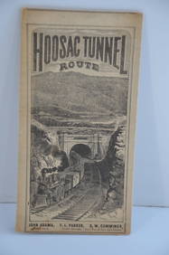
Fitchburg Railroad 1880 Hoosac Tunnel Route Public TimetableJM Hobby Supply and Railroad Artifact Auctions4.4(126)See Sold PriceFeb 24, 2024
FORT LARAMIE NATIONAL MONUMENT, WYOMING 1954North American Artifact Auctions4.6(182)See Sold PriceApr 20, 2024
Johann Homann Hand-Colored Map Engraving, c. 1730Auctions at Showplace4.5(726)See Sold PriceMar 17, 2024
Willem Blaeu, Etc. 17th C. Antiquarian Maps, 2Auctions at Showplace4.5(726)See Sold PriceMar 17, 2024
1845 Delisle/Bauche Map of Martinique -- Carte de l'Isle de la Martinique Colonie Francoise de l'uneJasper524.5(9.8k)See Sold PriceFeb 27, 2024
Two Hand-Colored 19th Century Maps of New Orleans and Louisiana, Larger- H.- 12 1/2 in., W.- 15 1/2Crescent City Auction Gallery4.3(229)See Sold PriceMar 08, 2024
Georg Bockler Map of Ancient Jerulsaem EtchingAuctions at Showplace4.5(726)See Sold PriceApr 07, 2024
Antique Dutch Painted Armoire, c. 1845, H.- 68 in., W.- 43 1/2 in., D.- 17 in.Crescent City Auction Gallery4.3(229)See Sold PriceMar 09, 2024
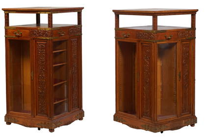
Pair of Aesthetic Carved Oak Revolving Bookmills, late 19th c., H.- 51 7/8 in., W.- 26 3/8 in., D.-Crescent City Auction Gallery4.3(229)See Sold PriceMar 09, 2024
"Map of the Parishes of Iberville Most of West Baton Rouge and Including Parts of the Parishes ofCrescent City Auction Gallery4.3(229)See Sold PriceMar 09, 2024