SoldChatelain (H. A.) Map of BohemiaChatelain (Henri Abraham) Carte du Royaume de Boheme. La Chronologie De Ses Rois. Les Etats de Silesie, Moravie, et Lusace,showing part of the Czech Republic and parts of Hungary and Austria,See Sold Price
Chatelain (H.) 3 maps Switzerland & AustriaChatelain (Henri Abraham) Carte Generale des Treize Cantons Suisse,with numerous coats-of-arms above and to lower corners, tables at each side; with Carte des Grisons.... et Quelques Autres EtSee Sold Price
Chatelain (H.) 4 maps of the German EmpireChatelain (Henri Abraham) 4 maps of the German Empire,ancient and modern, military and civil, all with text panels and tables, 1 with numerous inset smaller maps, 2 with inset views, engravedSee Sold Price
SoldH.A. CHATELAIN: Antique Map of New FranceChatelain, Henri Abraham "Carte de la Nouvelle France" ( "A Map of New France")1719 Copperplate engraving. Lower Loisiana is colored yellow, the pink area represents Canadian territory, the green BritSee Sold Price
SoldThree maps, late 18th-early 19th centuryThree mapslate 18th-early 19th centuryComprising a French hand-colored copperplate map of Virginia, 1760-1762; a map of the United States, 1719, by H.A. Chatelain, Amsterdam; and a map of Delaware, 18See Sold Price
SoldCHATELAIN, H. [North America], [1720]Chatelain, H. DRESSEE SUR LES PLUS NOUVELLES OBSERVATIONS DE MESSIEURS DE L’ACADEMIE... [Amsterdam, c.1720].Engraved map, outline colour, folds and minor imperfections, small loss affecting 4 lSee Sold Price
SoldChatelain (H.) Mappemonde... Globe TerrestreChatelain (Henri Abraham) Mappemonde ou Description Generale du Globe Terrestre,double-hemisphere world map with ornate border, California as an island, sun and moon in upper corners, tables bSee Sold Price
SoldChatelain (H.) Mappemonde... Globe TerrestreChatelain (Henri Abraham) Mappemonde ou Description Generale du Globe Terrestre,double-hemisphere world map with ornate border, California as an island, sun and moon in upper corners, tables bSee Sold Price
SoldChatelain, H. A. Carte Contenant le Royaume du MexiqueChatelain, H. A. Carte Contenant le Royaume du Mexique et la Floride... Amsterdam, 1719. Engraved map, 41x52 cm. Framed.See Sold Price
Chatelain (H A) Carte de L'Amerique[Chatelain (Henri Abraham)] Carte de L'Amerique, engraved sheet comprising a small map of the Americas (135 x 95mm.), 4 vignette scenes, and extensive text panels, 340 x 440mm., [Amsterdam],See Sold Price
Chatelain, HA. Carte du Canada ou de la Nouvelle FranceChatelain, Henri Abraham Carte du Canada ou de la Nouvelle France... 1718 Copperplate engraving; coloured Printed area: 53 x 41.5 cm; 20.9 x 16.3 in An important map in the history of Canada from theSee Sold Price
SoldChatelain (H.A.) Nouvelle Carte... de LondresChatelain (Henri Abraham) Nouvelle Carte du Gouvernement Civil d'Angleterre et de Celuy de la Ville de Londres,central plan of London, map of England and Wales above, two allegorical scenes inSee Sold Price
Chatelain, HA. Carte du Canada ou de la Nouvelle FranceChatelain, Henri Abraham Carte du Canada ou de la Nouvelle France 1719 Copperplate engraving; area coloured Printed area: 52 x 40.5; 20.5 cm x 16 in Chatelain's map of Canada & the Great Lakes was theSee Sold Price
SoldChatelain (H.A.) 10 plates of SwedenChatelain (Henri Abraham) 9 tables of Swedish genealogy and government organisation, 6 plates with maps and native rural scenes, 2 double-page plates with portrait medallions and vignette viewSee Sold Price
SoldMap of Bohemia, 19th centuryFramed hand-colored etching, Map of Bohemia, 19th century, overall: 27.75''h x 31.25''wSee Sold Price
Antique Print of the Map of Bohemia & Austria 1681Antique print of the map of Bohemia and Austria 1681. Fair condition. Some tears. Sold as is. 36" W x 25" H.See Sold Price
1708 Chatelain Map of England and London -- NouvelleTitle: 1708 Chatelain Map of England and London -- Nouvelle Carte du Gouvernement Civil d'Angleterre et de Celuy de la Ville de Londres Year/Place: 1708 c., Amsterdam Cartographer: H Chatelain Size: 1See Sold Price
1708 Chatelain Map of England and London -- NouvelleTitle: 1708 Chatelain Map of England and London -- Nouvelle Carte du Gouvernement Civil d'Angleterre et de Celuy de la Ville de Londres Date: 1708 c., Amsterdam Cartographer: H Chatelain Size: 13.8 XSee Sold Price
Sold1719 H. Chatelain - Carte de la Nouvelle France...Title: Carte de la Nouvelle France, ou se voit le Cours des Grandes Rivieres de S. Laurens & de Mississipi Aujour d'hui S. Louis, aux Environs des Quelles se Trouvent les Etats, Pais, Nations, PeuplesSee Sold Price
Soldfigurine, Meissenfigurine, Meissen, 2.H.20th c., designed by Reinicke 1744, card trader of the edition Criede Paris, with representation the map Saxonia/Bohemia/Bavaria, polychrome painted, gold decoration, H. 17 cmSee Sold Price
Nouvelle Carte des Etats du Grand Duc de Moscovie enNouvelle Carte des Etats du Grand Duc de Moscovie en Europe. Partie Sertentrionale. Kupferstichkarte. Amsterdam, H. Chatelain, um 1720. Plattengröße ca. 36,5 x 48,4 cm. Copper engr. map. - CentrefolSee Sold Price
Soldc.1680 A.M. Mallet Prague Bohemia Engraved MapSubject Matter: Prague with View of Vlatava River Engraver: Alain Manesson Mallet (1630-1706) Period: c. 1680 Engraving Dimensions (through mat window): 5 7/8"(h) x 4 1/4"(w) Frame Dimensions: 13"(h)See Sold Price
[Henri Abraham CHATELAIN] Nouvelle Carte de L’IrlandeFrom Atlas Historique, by H. A. Chatelain, 1718. Nouvelle Carte de L'Irlande, Hand-coloured maps. Map of the whole of Ireland (43 x 52 cm.) with two smaller maps. Some damp soiling, else good and cleaSee Sold Price
MAP - Dufour, A. H. ( Malte / Brun ) :MAP - ESPAGNE PARTIE SUD DIVISEE EN PROVINCES ANCIENNES ( MAPLuis Porretta Fine Arts4.3(10)See Sold PriceMar 02, 2024
Vintage County Map Of NY State Plate EngravingThe Benefit Shop Foundation Inc.4.3(2.9k)See Sold PriceFeb 28, 2024
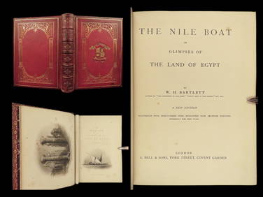
1880 Niles Boat Egypt Voyages Sphinx Pyramids Valley of Kings Illustrated MAPSSchilb Antiquarian Rare Books4.8(428)See Sold PriceMar 31, 2024
Chatelain - Map of the Americas and Details and Insets of Government CounselsTrillium Antique Prints & Rare Books4.5(32)See Sold PriceFeb 24, 2024
Chatelain - 3 Maps of the British Isles (England, Ireland, Scotland)Trillium Antique Prints & Rare Books4.5(32)See Sold PriceFeb 24, 2024
Large Royal Dux Bohemia Sea Life Vase, c. 1900, H.- 14 in., Dia.- 10 in.Crescent City Auction Gallery4.3(231)See Sold PriceMar 09, 2024
Robert H Labberton - Map of The Territory of the Present United States - The territory of theProverde Auctions4.3(3)See Sold PriceFeb 28, 2024
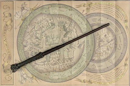
Universal Studios Harry Potter Wand BRapid Estate Liquidators and Auction Gallery4.5(1.1k)See Sold PriceFeb 28, 2024
Tavik Frantisek Simon, (Bohemia, 1877-1942) Color Etchings H 13.5" W 15.5" 2 pcsDuMouchelles4.6(830)See Sold PriceMar 15, 2024


![CHATELAIN, H. [North America], [1720] (1 of 11)](https://p1.liveauctioneers.com/1124/187577/94368858_1_x.jpg?height=282&quality=70&version=1607095126)


![[Henri Abraham CHATELAIN] Nouvelle Carte de L’Irlande (1 of 1)](https://p1.liveauctioneers.com/1187/57305/28080704_1_x.jpg?height=282&quality=70&version=1403622104)