SoldCelestial Map By Homann, 1730Historic MapsBeautiful Celestial Map By Homann 1730, GLOBI COELESTIS IN TABULAS PLANAS REDACTI PARS VI, by Homann, Nuremberg, Very Fine. 19” x 23”, uncolored image portion. Color side paneSee Sold Price
SoldCelestial Map By Homann, 1730MapsBeautiful Celestial Map By Homann 1730, GLOBI COELESTIS IN TABULAS PLANAS REDACTI PARS VI, by Homann, Nuremberg, Very Fine. 19” x 23”, uncolored image portion. Color side panels give lSee Sold Price
SoldCelestial Map By Homann, 1730MapsBeautiful Celestial Map By Homann 1730, GLOBI COELESTIS IN TABULAS PLANAS REDACTI PARS VI, by Homann, Nuremberg, Very Fine. 19” x 23”, uncolored image portion. Color side panels give lSee Sold Price
SoldCelestial Map By Homann, 1730MapsBeautiful Celestial Map By Homann 1730, GLOBI COELESTIS IN TABULAS PLANAS REDACTI PARS VI, by Homann, Nuremberg, Very Fine. 19” x 23”, uncolored image portion. Color side panels give lSee Sold Price
SoldCelestial Map By Homann, 1730Historic MapsBeautiful Celestial Map By Homann 1730, GLOBI COELESTIS IN TABULAS PLANAS REDACTI PARS VI, by Homann, Nuremberg, Very Fine. 19" x 23", uncolored image portion. Color side panels gSee Sold Price
Sold1 piece. Hand-Colored Engraved Celestial Map. Hom1 piece. Hand-Colored Engraved Celestial Map. Homann, John Baptist. Planiglobi Terrestris cum Utroq. Hemisphaerio Caelesti Generalis Exhibito." Nuremberg, [ca. 1730]. 19 1/4 x 22 1/2 inches; 489 x 570See Sold Price
SoldDoppelmayr/Homann: Northern Hemisphere Celestial MapTitle/Content of Map: 1742 Doppelmayr / Homann Celestial map of Northern Hemisphere -- Hemisphaerium Coeli Boreale in quo Fixarum Loca Secundum Eclipticae Ductum ad Anum 1730… Date Printed: 1742, NuSee Sold Price
MAPS, Celestial, DoppelmayrCelestial. Doppelmayr/Homann, [Lot of 5] Globi Coelestis in Tabulas Planas Redacti Pars II, III, IV, V, VI, 1730 (dated). Hand Color. This lot includes 5 of 6 large charts in this set, each depictingSee Sold Price
Sold[MAP OF THE WORLD] HOMANN, JOHANN BAPTISTPlaniglobii Terrestris cum Utroq Hemisphaerio Caelesti, double-page engraved double-hemispheric map with two celestial insets, with hand-coloring, Nuremburg, circa 1730, framed h. 19 w. 21-3/4 in. (siSee Sold Price
SoldMAP, Globes, SeutterCartographic Miscellany, Globes. Matthias Seutter, Sphaerae Artificiales Synoptica Idea Delineatiae et Propositae, 1730 (circa). Hand Color. This elegant engraving is from one of Homann's celestial atSee Sold Price
Sold1 piece. Partly Hand-Colored Engraved Celestial M1 piece. Partly Hand-Colored Engraved Celestial Map. Homann, Johann Baptist; Doppelmayer, Johann Gabriel. Hemisphaerium Coeli Boreale." Nuremberg, [1720]. 19 1/2 x 23 1/4 inches; 495 x 590 mm, marginSee Sold Price
SoldEighteenth Century Engraved Celestial MapsEighteenth Century Engraved Celestial Maps c.1730, two color tinted maps on vellum including the 'Hemisphareium Coeli Boreale' chart and the 'Globi Coelestis in Tabulas Planas redacti Pars I' Height:See Sold Price
Sold1730 Homann Map of Western Belgium and Northern FranceTitle/Content of Map: 1730 Homann Map of Western Belgium and Northern France -- Comitatus Flandriae in omnes ejusdem subjacentes Ditioes Cartographer: J Homann Year/Place: 1730 c., Nurnberg Size: 19 XSee Sold Price
Doppelmayr and Homann Celestial MapGlobi Coelestis in Tabula Planas Redacti Pars II 19 3/8" x 23" hand colored engraving 18th centurySee Sold Price
SoldRegnorum Hispaniae et Portugalliae, 1730 Homann Map ofRegnorum Hispaniae et Portugalliae, 1730 Homann Map of Spain and PortugalSee Sold Price
1730 Homann Map of Western Belgium and Northern FranceTitle/Content of Map: 1730 Homann Map of Western Belgium and Northern France -- Comitatus Flandriae in omnes ejusdem subjacentes Ditioes Cartographer: J Homann Year/Place: 1730 c., Nurnberg Size: 19 XSee Sold Price
SoldLarge Double-folio Hand-Colored and Engraved CelesLarge Double-folio Hand-Colored and Engraved Celestial Map, c. 1743, Homann family and heirs, Nuremburg, entitled "Planisphaerium Coeleste", with elaborate circular vignettes and a cartouche, with beaSee Sold Price
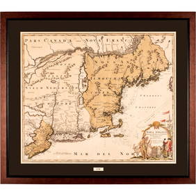
Soldc 1730 Hand-Colored Map of New England titled, NOVA ANGLIA Septentrionali America by Johannes HomannHistoric Maps Beautiful Circa 1730 "Homann" Map of Early New England c. 1730 Colonial Period, Hand-Colored Copper-plate Engraved Map of New England in America entitled, "NOVA ANGLIA Septentrionali AmeSee Sold Price
Soldc. 1730 Map of New England NOVA ANGLIA by HomannColonial America Beautiful circa 1730 “Homann” Map of Early New England c. 1730 Colonial Period, Hand-Colored Copper-plate Engraved Map of New England in America entitled, “NOVA ANGLIA SeptentriSee Sold Price
Homann: Antique Celestial Map of Solar System, 1752Map: 1752 Homann Solar System Map -- Systema Solare et Planetarium ex hypothesi Copernicana secundum elegantissimas Illustrissimi quondam Hugenii deductiones novissime collectum & exhibitum Date/PlaceSee Sold Price
SoldRare 1710 Johann Homann Color Celestial MapNuremberg; 1710. Johann Homann colored engraved celestial Hemispherium Coeli Boreale map printed on woven paper. It is displayed in eglomized glass and wood frame. Dimensions Map: 23" by 19" (58.4 cmSee Sold Price
SoldPhaenomena Motuum Irregularium, celestial mapPhaenomena Motuum Irregularium, celestial map, 18th c., Doppelmayr/Homann, each sheet: 19"h x 22.5"w (sight), 43.5"h x 26.75"w (framed ensuite) Provenance: Property from a New York Corporate CollectioSee Sold Price
Homann: Antique Solar System Celestial Map, 1752Title/Content of Map: 1752 Homann Solar System Map -- Systema Solare et Planetarium ex hypothesi Copernicana secundum elegantissimas Illustrissimi quondam Hugenii deductiones novissime collectum & exhSee Sold Price
SoldCa. 1730 Johann Homann Comitatus Flandriae MapCa. 1730 Comitatus Flandriae Map, 'Johann Baptist Homann' , 24" x 21.5"See Sold Price
Johann Homann Hand-Colored Map Engraving, c. 1730Auctions at Showplace4.5(726)See Sold PriceMar 17, 2024
1730 BIBLE in DUTCH ILLUSTRATED w/ MAPS antique MASSIVE FOLIO BIBLIAJasper524.5(9.8k)See Sold PriceFeb 27, 2024


![[MAP OF THE WORLD] HOMANN, JOHANN BAPTIST (1 of 8)](https://p1.liveauctioneers.com/522/152734/77123886_1_x.jpg?height=282&quality=70&version=1571345617)