SoldCary (John) A New Map of the East India IslesCary (John) A New Map of the East India Isles,engraved map with original hand-colouring, 500 x 550mm., central vertical fold, slight spotting, mostly marginal with slight damp-staining at sheeSee Sold Price
Cary (John) A New Map of the East India IslesCary (John) A New Map of the East India Isles,engraved map with original hand-colouring, 500 x 550mm., central vertical fold, slight spotting, mostly marginal with slight damp-staining at sheeSee Sold Price
Cary (John) A New Map of the East India IslesCary (John) A New Map of the East India Isles,engraved map with original hand-colouring, 500 x 550mm., central vertical fold, slight spotting, mostly marginal with slight damp-staining at sheeSee Sold Price
SoldJohn Cary, Engraver - A New Map of the East India Isles1801 49 x 55 cm (19 x 22 in)See Sold Price
SoldCARY,E. INDIA ISLES.,EGYPT,TARTARY - (3), C.1830Title: A New Map of East India Isles & …Egypt & …Tartary - group of 3, Printmaker: John Cary, Pub: John Cary, Date: C.1803, Medium: Hand-colored engraving, Paper size: 20 1/2 x 22 1/2 each, InscriSee Sold Price
SoldCary map of West Indies 1803Title: A New Map of the West India Isles, From the Latest Authorities Author: Cary, John Description: Copper-engraved map, slight hand-coloring in outline. 45.7x51.2 cm. (18x20¼").The islands of theSee Sold Price
Cary map of West Indies 1803Title: A New Map of the West India Isles, From the Latest Authorities Author: Cary, John Description: Copper-engraved map, slight hand-coloring in outline. 45.7x51.2 cm. (18x20¼").The islands of theSee Sold Price
SoldAntique Map, "West India Isles", a new map of the WestAntique Map, "West India Isles", a new map of the West India Isles from the latest Authorities, by John Cary,engraver, 1803, framed, 18.5" by 20.5". Notice: Please note that our auctions will continueSee Sold Price
SoldLondon.- Cary (John) Cary's New and Accurate Plan ofLondon.- Cary (John) Cary's New and Accurate Plan of London and Westminster, the Borough of Southwark and parts adjacent, large detailed map showing from Kensington to the East India Docks, and from CSee Sold Price
Thomson: Antique Map of East India Isles, 1817Title/Content of Map: East India Isles Cartographer: THOMSON, JOHN & CO. Size: 17.25X20.75 No.35 (unnumbered) from Thomson's New General Atlas 1817. T. Clerk sculpt. Edinr.Browned. Narrower margins thSee Sold Price
East India IslesTitle/Content of Map: East India Isles Date: 1817 Cartographer: THOMSON, JOHN & CO. Publisher: JOHN THOMSON, JUNR. & CO. Size: 17.25Height - 20.75Width No.35 (unnumbered) from Thomson's New General AtSee Sold Price
Sold-. Speed (John) A New Map of East India-. Speed (John) A New Map of East India,1st and only edition, title cartouche supported by costume figures, upper right, engraved map with hand-colouring, 385 x 495mm., English text verso withSee Sold Price
Speed (John) A New Map of East IndiaSpeed (John) A New Map of East India,from Speed's atlas 'The Prospect of the Most Famous Parts of the World', with decorative title cartouche upper centre, engraved map by Francis Lamb, 390 xSee Sold Price
SoldSpeed (John) A New Map of East IndiaSpeed (John) A New Map of East India,1st and only edition, title cartouche supported by costume figures, upper right, engraved map with hand-colouring, 385 x 495mm., English text verso with woSee Sold Price
SoldSpeed (John) A New Map of East IndiaSpeed (John) A New Map of East India,from Speed's atlas 'The Prospect of the Most Famous Parts of the World', with decorative title cartouche upper centre, engraved map, by Francis Lamb, 390 xSee Sold Price
SoldAsia.- East Indies.- Speed (John) A New Map of EastAsia.- East Indies.- Speed (John) A New Map of East India, map of south east Asia showing from India, Ceylon, Indonesia, Malay Peninsula, and the Philippines, engraving with hand-colouring, platemarkSee Sold Price
SoldAsia.- East Indies.- Speed (John) A New Map of EastAsia.- East Indies.- Speed (John) A New Map of East India, map of south east Asia showing from India, Ceylon, Indonesia, Malay Peninsula, and the Philippines, engraving with hand-colouring, platemarkSee Sold Price
Speed Map of East Indies*** START PRICE IS THE RESERVE *** [Asia] SPEED, John (1552-1629). A New Map of East India. Engraved map. London: 1676. 17" x 21 1/2" sheet. Comparable: Bloomsbury Auctions, 2013 - £1,769. The mSee Sold Price
SoldThomson: East India IslesMap: East India Isles. Cartographer: John Thomson Place/Date: Edinburgh / 1816 Size: 20 3/4" x 171/2" Condition: outline color; overall age toning, overprinting and marginal staining, repaired splitsSee Sold Price
SoldThomas Clerk EAST INDIA ISLES MAP 1817 Antique EngravedThomas Clerk EAST INDIA ISLES MAP 1817 Antique Engraved Hand‐Colored Map John Thomson & Co. John Thomson Junr. & Co. Edinburgh Cartography Indian Ocean China Sea Philippine Islands PacifSee Sold Price
SoldJohn Pinkerton, map of East IndiesJohn Pinkerton, map of East Indies, John Pinkerton (Scottish, 1758-1826), "East India Isles", c. 1818, map of the East Indies and Southeast Asia (Singapore, Borneo, Java, Sumatra, Thailand), 21.5"h xSee Sold Price
Cary (John) - A New Map of North America from thethe continent", joined in the north east with Greenland, also showing Iceland, the West Indies and Central America, the United States confined east of the Mississippi, the north west regions of AlaskaSee Sold Price
SoldCary (John) A New Map of ScotlandCary (John) A New Map of Scotland,with inset maps of the The Shetland Isles and the Orkney Islands, engraved map with full hand-colouring, 910 x 1050mm., dissected and linen-backed, some offseSee Sold Price
SoldCary (George and John) Cary's New Plan of London aCary (George and John) Cary's New Plan of London and its Vicinity,from Newington Green to North Brixton and from East India Docks to Kensington Gore, title panel below, unrecorded edition showSee Sold Price
Portfolio of 15 County Maps by Robert Morden (English 1650-1703)Nadeau's Auction Gallery4.7(405)See Sold PriceFeb 24, 2024
[ARCTIC]. BOWEN, Emanuel. A New & Accurate Map of the North...Potter & Potter Auctions4.6(544)See Sold PriceMar 07, 2024
[CLIPPER SHIP CARD]. Sutton & Co’s Dispatch Line for San Fr...Potter & Potter Auctions4.6(544)See Sold PriceMar 07, 2024
[LITHOGRAPHY]. Group of 41 Trade Cards for American Domesti...Potter & Potter Auctions4.6(544)See Sold PriceMar 07, 2024
Map: A 19thC engraved map titled Gloucestershire from the Best Authorities, after John Cary. Approx.Claydon Auctioneers Ltd4.3(125)See Sold PriceFeb 26, 2024
Map: A 19thC engraved and hand coloured map of Buckingham titled A New Map of BuckinghamshireClaydon Auctioneers Ltd4.3(125)See Sold PriceFeb 26, 2024
Map: A 19thC engraved map of West Riding, titled A Map of the North Part of the West Riding ofClaydon Auctioneers Ltd4.3(125)See Sold PriceFeb 26, 2024
1830 SERMON PREACHED at HAVERHILL MASS by LEONARD WOODS antique AMERICANAJasper524.5(9.8k)See Sold PriceFeb 27, 2024
Medicine.- Kennedy (James) The History of the Contagious Cholera, first edition, 1831 & others (11)Forum Auctions4.3(53)See Sold PriceFeb 29, 2024
New and Correct Map of North America With the West India Islands,Jasper524.5(9.8k)See Sold PriceFeb 27, 2024
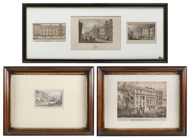
FIVE ARCHITECTURAL PRINTS OF HISTORIC NEW YORK AND LONDON BUILDINGS 19th CenturyEldred's4.7(418)See Sold PriceMar 07, 2024
Churchill & Nieuhof 1744 Folio Map. Batavia Indonesia East IndiesAlbion Auctions4.6(341)See Sold PriceMar 01, 2024
BOYD ORR JOHN: (1880-1971)International Autograph Auctions Europe S.L.4.5(52)See Sold PriceMar 14, 2024


![[ARCTIC]. BOWEN, Emanuel. A New & Accurate Map of the North... (1 of 1)](https://p1.liveauctioneers.com/928/318880/171360917_1_x.jpg?height=282&quality=70&version=1707501302)
![[CLIPPER SHIP CARD]. Sutton & Co’s Dispatch Line for San Fr... (1 of 2)](https://p1.liveauctioneers.com/928/318880/171360962_1_x.jpg?height=282&quality=70&version=1707501302)
![[LITHOGRAPHY]. Group of 41 Trade Cards for American Domesti... (1 of 1)](https://p1.liveauctioneers.com/928/318880/171361100_1_x.jpg?height=282&quality=70&version=1707501302)