MATTHEWS c1856 Map Of Upper Canada Ontario Indian Land Agency Divisions Scarce!Luis Porretta Fine Arts4.3(10)See Sold PriceMar 02, 2024
DEVINE c1856 Dr Salters Map Of Lake Huron Ontario Indian Lands etc. No. 7 ScarceLuis Porretta Fine Arts4.3(10)See Sold PriceMar 02, 2024
DUNLEVIE c1856 Map Counties Of Gaspe & Bonaventure Quebec Canada SCARCE! #1Luis Porretta Fine Arts4.3(10)See Sold PriceMar 02, 2024
DUNLEVIE c1856 Map Counties Of Gaspe & Bonaventure Quebec Canada SCARCE! #2Luis Porretta Fine Arts4.3(10)See Sold PriceMar 02, 2024
Map UNITED COUNTIES LEEDS & GRENVILLE by Walling 1861 Rare Canada Map 5ft x 5ftLuis Porretta Fine Arts4.3(10)See Sold PriceMar 02, 2024
Ambroise TARDIEU c1822 Map Venice Napoleon Italian Campaign 17" x 11"Luis Porretta Fine Arts4.3(10)See Sold PriceMar 02, 2024
SoldCarey & Lea Map of Rhode Island, 1822Cartographer: Carey & Lea Year/Place of Publishing: 1822, Philadelphia 1822 Carey and Lea Map of Rhode Island -- Geographical, Statistical, and Historical Map of Rhode Island. This excellent early mapSee Sold Price
Carey and Lea, Geographical, Statistical, andCAREY & LEA. Geographical, Statistical, and Historical Map of Rhode Island. Philadelphia: H. C. Carey & I. Lea, 1827. Originally published in “A Complete Historical, Chronological, and GeographicalSee Sold Price
SoldGeographical, Statistical and Historical Map of CubaTitle: Geographical, Statistical and Historical Map of Cuba and the Bahama Islands Printing Date: 1822 Cartographer: TANNER, BENJAMIN Publisher: H.C. CAREY & I. LEA Size: 9.6Height - 13.75Width AdditiSee Sold Price
Tanner Map of CubaTanner, Benjamin (1775-1848). Geographical, Statistical and Historical Map of Cuba and the Bahama Islands. Engraved map. H. C. Carey & I. Lea, 1822. 9 â…" x 13 ¾" No.40. Quarto size sharp plateSee Sold Price
Tanner Map of CubaTanner, Benjamin (1775-1848). Geographical, Statistical and Historical Map of Cuba and the Bahama Islands. Engraved map. H. C. Carey & I. Lea, 1822. 9 â…" x 13 ¾". No.40. Quarto size sharp plateSee Sold Price
Map, H.C. Carey and I. LeaHenry Charles Carey (American, 1793-1879) and Isaac Lea (American, 1792-1886), "Geographical, Statistical and Historical Map of Port Rico and the Virgin Islands (No. 53)," 1822, hand-colored engravingSee Sold Price
SoldCarey & Lea's 1822 map of U.S. engraved by TannerTitle: United States of America Author: Carey & Lea Description: Copper-engraved map, hand-colored. Engraved by B. Tanner. 43.2x54.5 cm. (17x21½").Important map of the United States, issued in CareySee Sold Price
SoldCarey & Lea's 1822 Map of the United StatesDESCRIPTION: Carey & Lea's 1822 Map of the United States. Handcolored engraving on wove paper. Engraved by B. Tanner. Matted in wood frame. MEASUREMENTS: 17" x 21-1/2". Overall with frame 27-3/4" x 31See Sold Price
SoldCarey & Lea's 1822 map of U.S. engraved by TannerTitle: United States of America Author: Carey & Lea Description: Copper-engraved map, hand-colored. Engraved by B. Tanner. 43.2x54.5 cm. (17x21½"). Important map of the United States, issued in CareySee Sold Price
SoldSTATE I MAP OF CAREY AND LEA'S 1822 MAP OF MAINE.A geographical, historical and statistical map of Maine. The image of the state is color coded to conform to the text that surrounds the map in the original. This map can be found on pages 130-131 inSee Sold Price
SoldCarey & Lea: Antique Map of North America, 1822Map: Geographical, Statistical, and Historical Map of North America Publication Date: 1822 Authors: CAREY & LEA, FINLAYSON, J./J. YEAGER Publisher: CAREY & LEA Size: Double Folio – 13.75 H x 13.30 WSee Sold Price
SoldTN Map 1822, Lucas, Carey, & Lea"Geographical, Statistical, And Historical Map of Tennessee", drawn by Fielding Lucas, Jr., engraved by William Kneass, published by Henry C. Carey and Issac Lea, Philadelphia, 1822. From "A CompleteSee Sold Price
SoldCarey & Lea: Antique Map of West Indies, 1822Title/Content of Map: West Indies Date Printed: 1822 Cartographer: Henry C. Carey and Isaac Lea Material/Medium: Hand Coloured Engraving Size: 17 7/8" x 22 3/8" Atlas Folio Please note that this lot hSee Sold Price
Carey & Lea: Antique Historical Map of Hispaniola, 1822Map: Geographical, Statistical, and Historical Map of Hispaniola, Or St. Domingo. Publication Date: 1822 Authors: CAREY & LEA, LUCAS, FIELDING JR. Publisher: CAREY & LEA Size: Folio – 11.60 H x 17.7See Sold Price
Carey & Lea: Antique Geographical Map of Jamaica, 1822Map: Geographical, Statistical, and Historical Map of Jamaica Publication Date: 1822 Authors: CAREY & LEA, FINLAYSON, J. Publisher: CAREY & LEA Size: Folio – 11.30 H x 12.00 W Inches Map detailing tSee Sold Price
Carey & Lea: Antique Map of the Leeward Islands, 1827Map: Geographical, Statistical, and Historical Map of the Leeward Islands. Publication Date: 1827 Authors: CAREY & LEA, YEAGER, J. Publisher: CAREY & LEA Size: Quarto – 12.00 H x 9.50 W Inches Map oSee Sold Price
Sold8 Maps from 1822 Carey & Lea Atlas Incl. Maryland8 Maps from 1822 Carey & Lea Atlas Incl. Maryland, Massachusetts, New Hampshire, Jamaica-- Dimensions: ---See Sold Price
SoldCarey & Lea: Antique Map of Porto Rico & Virgin IslandsTitle/Content of Map: Porto Rico and Virgin Islands Date Printed: 1822 Cartographer: Henry C. Carey and Isaac Lea Material/Medium: Engraving Size: 17 3/4" x 22" sheet Atlas Folio, hard to find map ofSee Sold Price
Scarce 1816 map of Rhode Island by M. CareyCharming and very early map of Rhode Island with original outline hand coloring by counties. Shows towns, settlements, major routes, waterways, meadows, swamps, bridges, ponds, ferries, hills, islandsSee Sold Price
SoldAntique Map of Louisiana, Carey & Lea, 1822Antique Map of Louisiana , "Geographical, Statistical and Historical Map of Louisiana", Philadelphia, Carey & Lea, 1822, 16 3/4 in. x 21 1/4 in., framed . Provenance: By repute, Arader Galleries, NewSee Sold Price
Leeward Islands Map C. 1823Geographical, Statistical and Historical Map of the Leeward Islands. 1823. Engraver: J. Yeagar. Publisher: Carey & Lea. Hand-colored. Condition: Some discoloration.; 17 1/2" x 22"See Sold Price
SoldJOHN MELISH (SCOTTISH-AMERICAN, 1771-1822) MAP OF THEJOHN MELISH (SCOTTISH-AMERICAN, 1771-1822) MAP OF THE UNITED STATES, hand-colored engraving on paper, engraved by Benjamin Tanner (American, 1775-1848), from Carey & Lea's "A Complete Historical, ChroSee Sold Price
SoldTHREE 19TH CENTURY MAPS OF THE MIDDLE EAST AND TURKEYIncludes an 1822 'Reign of Solomon' map, published by Carey & Lea, Philadelphia, matted, 10 x 8 inch sight size; also 'Turkey,' by Carey and Lea in 1822, same sight size; and an 1869 Stieler map, 'TheSee Sold Price
SoldTWO 19TH CENTURY MAPS OF PERSIA AND SYRIAIncludes an 1822 map of Persia by Carey and Lea, from 'The Juvenile Atlas,' professionally matted, 7.75 x 9.75 inch sight size; and an 1822 era map of Syria and Assyria, also matted, 8 x 10.25 inch siSee Sold Price
1853 Colton's Railroad & Township Map of Massachusetts, Rhode Island, and ConnecticutRail & Road Auctions4.6(165)See Sold PriceMar 07, 2024
1849 THE NEW-ENGLAND MERCANTILE UNIONNorth American Artifact Auctions4.7(201)See Sold PriceApr 20, 2024
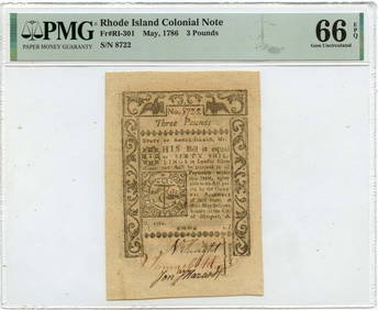
May 1786 3 Pounds Rhode Island Colonial Note RI-301 PMG Gem 66 EPQMynt Auctions4.6(711)See Sold PriceFeb 24, 2024
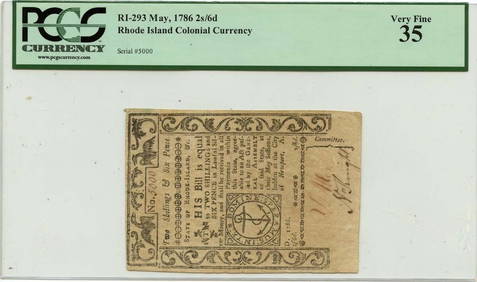
1780 July 2 $4 Rhode Island Colonial Note RI-285 PMG AU58 IssuedMynt Auctions4.6(711)See Sold PriceFeb 24, 2024
July 2 $2 Rhode Island Colonial Note 1780 RI-283 PMG AU58 EPQMynt Auctions4.6(711)See Sold PriceFeb 25, 2024
1780 July 2 $7 Rhode Island Colonial Note RI-287 PMG AU53 IssuedMynt Auctions4.6(711)See Sold PriceFeb 26, 2024
RHODE ISLAND CHIPPENDALE SLANT FRONT DESK.Amelia Jeffers, Auctioneers & Appraisers4.5(124)See Sold PriceMar 08, 2024
1822 MAP of LEEWARD ISLANDS GEOGRAPHICAL STATISTICAL HISTORICAL antique 17.5x22"Jasper524.5(9.9k)See Sold PriceFeb 27, 2024
1822 MAP of SOUTH AMERICA GEOGRAPHICAL STATISTICAL HISTORICAL antique 17.5x 22"Jasper524.5(9.9k)See Sold PriceFeb 27, 2024
1822 MAP of NORTH & SOUTH AMERICA GEOGRAPHICAL STATISTICAL HISTORICAL antiqueJasper524.5(9.9k)See Sold PriceFeb 27, 2024
1822 MAP of CHILI GEOGRAPHICAL STATISTICAL HISTORICAL antique 17.5x 22" CHILEJasper524.5(9.9k)See Sold PriceFeb 27, 2024
Geographical, Statistical, and Historical Map of the Leeward Islands.Jasper524.5(9.9k)See Sold PriceFeb 27, 2024
Geographical Statistical and Historical Map of the Windward IslandsJasper524.5(9.9k)See Sold PriceFeb 27, 2024
TWO PRINTS DEPICTING WATCH HILL, RHODE ISLAND Framed 18.5" x 21" and 19.5" x 21".Eldred's4.7(423)See Sold PriceMar 07, 2024
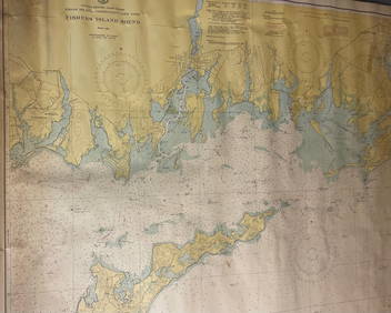
CHART: UNITED STATES - EAST COAST/ RHODE ISLAND - CONNECTICUT - NEW YORK/ Fishers IslandChurchill Galleries3.7(217)See Sold PriceFeb 26, 2024
1779 Rhode Island Ship Token Colonial MS-65 NGC (Brass VLUGTENDE)Golden Gate Auctioneer4.2(284)See Sold PriceFeb 25, 2024
Joan Grober (AMERICAN / RHODE ISLAND, 20th Century) watercolor work on artist paper depicting aJoshua Kodner4.2(395)See Sold PriceMar 09, 2024
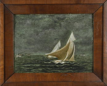
ANTIQUE AMERICAN SCHOOL OIL, RHODE ISLAND YACHT RACE.William Smith Auctions4.6(147)See Sold PriceMar 06, 2024