Soldc1850 Bradford County PA WALL MAP Towanda AthensTitle: Bradford County, Pennsylvania Draughtsman/Cartographer/Surveyor: Lake Ames & Davison Publisher: William J. Barker (Philadelphia) Printing Year: c1850 Dimensions: 60 inches x 39 inchesSee Sold Price
Soldc1850 Dutchess County NY WALL MAP PoughkeepsieTitle: Dutchess County, New York Draughtsman/Cartographer/Surveyor: J. C. Sidney Publisher: John E. Gillett Printing Year: c1850 Dimensions: 42 inches x 58 inches Condition/Details: ThisSee Sold Price
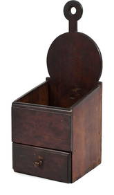
SoldWrought iron bootscrapeWrought iron bootscrape, 10 1/2'' h., 18'' w. Provenance: found near Towanda, Bradford County, PA.See Sold Price
Sold1858 Bridgens Wall Map of Cumberland County, PADESCRIPTION: 1858 H.F. Bridgens Map of Cumberland County, Pennsylvania. Including a close-up plan of Newville, Shippensburg, and Mechanicsburg. Also with an image of the Courthouse in Carlisle, PennsySee Sold Price
SoldScott's 1843 wall map of Lancaster County, PA. 40"Scott's 1843 wall map of Lancaster County, PA. 40" x 46", with an inset map of the lower Susquehanna River and the Tide Water Canal, where it runs into the Chesapeake Bay at Havre De Grace, MD. Map suSee Sold Price
Two 19th C. Hanging Wall Maps, NY & PennsylvaniaBeers Lake and Beers wall map of Columbia County, NY, Philadelphia,1858, and Smith, Gallup and Co. wall map of Northampton County, PA, Philadelphia, 1860. Each in fair to poor condition with staining,See Sold Price
Sold1832 Bradford County, PA Sampler.Bradford County, PA Needlework Sampler. "Miriam Buswell of Wilmot. Born February the 12th 1823". With verse and dated (when made) "August the 12, 1832". In a molded frame, 17-1/4" x 19-1/4" overall. CSee Sold Price
SoldWall map of Alameda County 1907Heading: Author: Prather, Edward C. and P.A. Haviland Title: Official Map of Alameda County California Place Published: Oakland, Cal. Publisher:Published by Tribune Publishing Company Date PubliSee Sold Price
Sold6 Maps: Delaware Co., PA; Baltimore; World...[Pennsylvania/Maryland/World]. 6 Wall Maps. Printed color. Contemp roller, most on linen backing. Sold with all faults.++ MAP OF DELAWARE COUNTY PENNSYLVANIA…by A. H. Mueller & Co., Phila., PA 1901.See Sold Price
Sold1855 Jefferson County, NY Wall MapJ.B. Shields Publisher. 55" x 54". In poor condition with staining and roughness along edges. Perimeter shows important buildings around the county at that time. From Col. Elisha Camp's Federal Home iSee Sold Price
SoldLARGE WALL MAP ULSTER COUNTY NEW YORKLARGE WALL MAP ULSTER COUNTY NEW YORK-OLIVER TILLSON, C. 1853 44" X 54"See Sold Price
SoldFarm Maps of Chester County, PA21" x 15 1/2" Printed by W.H. Kirk & Co. Philadelphia 1883. Colored maps are 20 1/2" x 28". Along with an 20 1/2' x 28 1/2" unframed colored map of Schuylkill, PA.See Sold Price
Sold1858 Bridgens Map of Cumberland County, PADESCRIPTION: 1858 H.F. Bridgens Map of Cumberland County, Pennsylvania including a close-up plan of Newville, Shippensburg, and Mechanicsburg. Also with an image of the Courthouse in Carlisle, PennsylSee Sold Price
SoldAntique 1858 Wall Map of Columbia County,NY New YorkLarge antique c.1858 map of Columbia county New York. This large map has lots of great details. It is perfect for anyone interested in local Hudson Valley history. The dimensions are 57in x 66in x 1.5See Sold Price
Sold1864 Lancaster County, PA AtlasHand colored maps of each town from actual surveys by H.F. Bridgens and Assistant.See Sold Price
SoldIreland - Roque, John 1762 Large Rare Wall Map"A Map of the Kingdom of Ireland Divided into Provinces, Counties and Baronies" Large Copper Engraved Map with original hand colour. Published 1762 by Robert Sayer. 4 Joined Sheets to form one large mSee Sold Price
Sold1870s Neb., Dak., Montana & WyomingScarce regional map, colored by counties and showing towns, mountains, rivers, railroads, etc. Originally engraved in the late 1850s as part of a wall map by Rogers & Johnston, this map represents a uSee Sold Price
SoldBRITISH MAP OF ENGLAND AND WALES NEEDLEWORK SAMPLERBRITISH MAP OF ENGLAND AND WALES NEEDLEWORK SAMPLER, silk on linen, oval vignette featuring the map of England and Wales with counties outlined and named, surrounding areas named including Scotland, ISee Sold Price
SoldPainting, Buck County PA landscape, Eugene C. FrankPainting, oil on canvas, Buck County Pennsylvania, Delaware river landscape, village in back ground, signed Eugene C. Frank, 23 3/4" x 34 3/4"See Sold Price
Sold1860's Lebanon County Pa Folk Art Watercolor Book1860's Lebanon County PA folk art watercolor book. Newspaper cover and backing with string binding. Eight pages. This was the master book. Dimensions: 8" x 6 1/2" Please note that this lot has a confiSee Sold Price
SoldLancaster County PA Fraktur Watercolor and Ink on Paperon Paper of Parrot feeding Chicks, Stylized Borders, Vines, Flowers, and Fruit in Green, Red, and Yellow, 4.25" x 6.375" with Frame 7.125" x 9.125" Condition: GoodSee Sold Price
SoldWalter Emerson Baum, Snow Landscape Oil Bucks County PAWalter Emerson Baum, Snow Landscape Oil Bucks County PA. All original untouched condition. Signed on front: W E BAUM; Signed and titled "Brook on the Road" on verso with attached Walter Baum biographySee Sold Price
Sold1854 JACOB MONK WALL MAP OF N. AMERICA & U.SSHOWING ONE OF THE MOST INTERESTING AND ATTRACTIVE 19TH CENTURY WALL MAPS OF NORTH AMERICA . PUBLISHED 1854 BY JACOB MONK , THIS LARGE AND BEAUTIFUL WALL MAP DETAILS MUCH OF NORTH AMERICA FROM THE SOUSee Sold Price
Lebanon County PA Watercolor Fraktur, 1840A dated 1840 hand-drawn Watercolor Fraktur on paper from Lebanon County, Pennsylvania with 2 Angels and 2 birds. Hand-written lettering is all in German but Lebanon and Pennsylvania are easily identifSee Sold Price
Crams Map of North Dakota-Complete Railroad System and County Map-1907JM Hobby Supply and Railroad Artifact Auctions4.4(126)See Sold PriceFeb 24, 2024
Rand McNally County/Township/Railroad Map of Kansas-1911JM Hobby Supply and Railroad Artifact Auctions4.4(126)See Sold PriceFeb 24, 2024
Rand McNally Township County and Railroad Map of Illinois-1879JM Hobby Supply and Railroad Artifact Auctions4.4(126)See Sold PriceFeb 24, 2024
Rand McNally Township County and Railroad Map of Indiana-1880JM Hobby Supply and Railroad Artifact Auctions4.4(126)See Sold PriceFeb 24, 2024
FLYING A TOURING SERVICE U.S. ROAD MAPS TIN WALL DISPLAY.Dan Morphy Auctions4.2(1.3k)See Sold PriceFeb 25, 2024
Vintage County Map Of NY State Plate EngravingThe Benefit Shop Foundation Inc.4.3(2.9k)See Sold PriceFeb 28, 2024
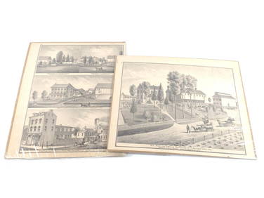
Portfolio of 15 County Maps by Robert Morden (English 1650-1703)Nadeau's Auction Gallery4.7(398)See Sold PriceFeb 24, 2024
Vintage Vanguard Studio wall map, dated 1968South Jersey Auction by Babington Auction Inc4.6(119)See Sold PriceFeb 25, 2024
3 Vintage The World Lithographs, By JanssonThe Benefit Shop Foundation Inc.4.3(2.9k)See Sold PriceMar 13, 2024
Vintage 1920s Rand McNally Auto Trails MapThe Benefit Shop Foundation Inc.4.3(2.9k)See Sold PriceMar 20, 2024