SoldC. Smith Publ. New Map of Rutland, 1808 17 x19in.C. Smith Publ. unframed coloured engraving New Map of Rutland, 1808 17 x19in.See Sold Price
SoldBritish early 19th century- ''A New Map of the CountyBritish early 19th century- ''A New Map of the County of Suffolk, 2nd edition Corrected to 1808'' publ, C Smith, No 172 Strand, Publ January 6th 1804; hand-coloured engraved map; 48x53cm: Robert MordeSee Sold Price
1808 Smith Map of Berkshire UK -- A New Map of theTitle/Content of Map: 1808 Smith Map of Berkshire UK -- A New Map of the County of Berks Divided into Hundreds Cartographer: C Smith Year/Place: 1808, London Size: 17.4 x 19.5 in. This is a very attraSee Sold Price
Sold1808 Smith Map of Cambridge UK -- A New Map of theTitle: 1808 Smith Map of Cambridge UK -- A New Map of the County of Cambridge Divided into Hundreds Date: 1808, London Cartographer: C Smith Size: 19.5 x 17.4 in. Additional Information: This is a verSee Sold Price
1808 Smith Map of Cambridge UK -- A New Map of theTitle: 1808 Smith Map of Cambridge UK -- A New Map of the County of Cambridge Divided into Hundreds Date: 1808, London Cartographer: C Smith Size: 19.5 x 17.4 in. Additional Information: This is a verSee Sold Price
1808 Smith Map of Cambridge UK -- A New Map of theTitle: 1808 Smith Map of Cambridge UK -- A New Map of the County of Cambridge Divided into Hundreds Date: 1808, London Cartographer: C Smith Size: 19.5 x 17.4 in. Additional Information: This is a verSee Sold Price
1808 Smith Map of Berkshire UK -- A New Map of theTitle/Content of Map: 1808 Smith Map of Berkshire UK -- A New Map of the County of Berks Divided into Hundreds Date Printed: 1808, London Cartographer: C Smith Size: 17.4 x 19.5 in. This is a very attSee Sold Price
1808 Smith Map of Berkshire UK -- A New Map of theReserve Reduced! Title/Content of Map:1808 Smith Map of Berkshire UK -- A New Map of the County of Berks Divided into Hundreds Date:1808, London Cartographer:C Smith Size:17.4 x 19.5 in. This is a verSee Sold Price
1808 Smith Map of Berkshire UK -- A New Map of theTitle/Content of Map: 1808 Smith Map of Berkshire UK -- A New Map of the County of Berks Divided into Hundreds Date Printed: 1808, London Cartographer: C Smith Size: 17.4 x 19.5 in. This is a very attSee Sold Price
1808 Smith Map of Berkshire UK -- A New Map of theTitle/Content of Map: 1808 Smith Map of Berkshire UK -- A New Map of the County of Berks Divided into Hundreds Date: 1808, London Cartographer: C Smith Size: 17.4 x 19.5 in. This is a very attractiveSee Sold Price
1808 Smith Map of Berkshire UK -- A New Map of theTitle: 1808 Smith Map of Berkshire UK -- A New Map of the County of Berks Divided into Hundreds Date: 1808, London Cartographer: C Smith Size:17.4 x 19.5 in. Description: This is a very attractive mapSee Sold Price
1808 Smith Map of Berkshire UK -- A New Map of theTitle/Content of Map: 1808 Smith Map of Berkshire UK -- A New Map of the County of Berks Divided into Hundreds Date Printed: 1808, London Cartographer: C Smith Size: 17.4 x 19.5 in. This is a very attSee Sold Price
Smith: Antique Map of Berkshire UK, 1808Title/Content of Map: 1808 Smith Map of Berkshire UK -- A New Map of the County of Berks Divided into Hundreds Date Printed: 1808, London Cartographer: C Smith Size: 17.4 x 19.5 in. This is a very attSee Sold Price
Smith: Antique Map of Berkshire UK, 1808Title/Content of Map: 1808 Smith Map of Berkshire UK -- A New Map of the County of Berks Divided into Hundreds Date Printed: 1808, London Cartographer: C Smith Size: 17.4 x 19.5 in. This is a very attSee Sold Price
Smith: Antique Map of Berkshire UK, 1808Map: 1808 Smith Map of Berkshire UK -- A New Map of the County of Berks Divided into Hundreds Date Printed: 1808, London Cartographer: C Smith Size: 17.4 x 19.5 in. Condition: Very Good. Sharp imagesSee Sold Price
Smith: Antique Map of Berkshire UK, 1808Title/Content of Map: 1808 Smith Map of Berkshire UK -- A New Map of the County of Berks Divided into Hundreds Date Printed: 1808, London Cartographer: C Smith Size: 17.4 x 19.5 in. This is a very attSee Sold Price
1808 Smith Map of Cambridge UK -- A New Map of theReserve Reduced! Title/Content of Map:1808 Smith Map of Cambridge UK -- A New Map of the County of Cambridge Divided into Hundreds Date:1808, London Cartographer:C Smith Size:19.5 x 17.4 in. This is aSee Sold Price
1808 Smith Map of Cambridge UK -- A New Map of theTitle/Content of Map: 1808 Smith Map of Cambridge UK -- A New Map of the County of Cambridge Divided into Hundreds Date: 1808, London Cartographer: C Smith Size: 19.5 x 17.4 in. This is a very attractSee Sold Price
1808 Smith Map of Cambridge UK -- A New Map of theTitle/Content of Map: 1808 Smith Map of Cambridge UK -- A New Map of the County of Cambridge Divided into Hundreds Date: 1808, London Cartographer: C Smith Size: 19.5 x 17.4 in. This is a very attractSee Sold Price
Smith: Antique Map of Cambridge UK, 1808Title/Content of Map: 1808 Smith Map of Cambridge UK -- A New Map of the County of Cambridge Divided into Hundreds Date Printed: 1808, London Cartographer: C Smith Size: 19.5 x 17.4 in. Condition: VerSee Sold Price
Smith: Antique Map of Cambridge UK, 1808Title/Content of Map: 1808 Smith Map of Cambridge UK -- A New Map of the County of Cambridge Divided into Hundreds Date Printed: 1808, London Cartographer: C Smith Size: 19.5 x 17.4 in. This is a verySee Sold Price
Smith: Antique Map of Cambridge UK, 1808Title/Content of Map: 1808 Smith Map of Cambridge UK -- A New Map of the County of Cambridge Divided into Hundreds Date Printed: 1808, London Cartographer: C Smith Size: 19.5 x 17.4 in. This is a verySee Sold Price
SoldGeographic map / Carte géographique"New map of the County of Monmouth", printed for C. Smith 1808, framed, excellent condition / "New map of the County of Monmouth", imprimée pour C. Smith 1808, encadrée, excellente conditionSee Sold Price
SoldCharles Smith (18th-19th Century) British. "A New MapCharles Smith (18th-19th Century) British. "A New Map of the County of Rutland", 1801, Engraved Map, 17.25" x 19.25".See Sold Price
Richard Pionk (NY,MN,1936-2007) pastel paintingBroward Auction Gallery4.7(300)See Sold PriceMar 17, 2024
Arthur Begay (AZ,NM,1932-2010) watercolor paintingBroward Auction Gallery4.7(300)See Sold PriceMar 31, 2024
LATE 17TH C. FRENCH MAP OF THE NEW WORLD BY ALEXIS-HUBERT JAILLOT (1632-1712)Thomaston Place Auction Galleries4.4(394)See Sold PriceFeb 24, 2024
18TH C. ANTIQUE MAP: FRENCH & INDIAN WAR, FRAMEDThomaston Place Auction Galleries4.4(394)See Sold PriceFeb 24, 2024
PRESENTATION GALL & LEMBKE BRASS TWO-DRAW FLOOR-STANDING TELESCOPE WITH CRANK TRIPOD New York, 19thEldred's4.7(423)See Sold PriceFeb 28, 2024
Johann Homann Hand-Colored Map Engraving, c. 1730Auctions at Showplace4.6(744)See Sold PriceMar 17, 2024
Willem Blaeu, Etc. 17th C. Antiquarian Maps, 2Auctions at Showplace4.6(744)See Sold PriceMar 17, 2024
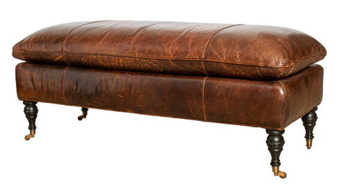
George Smith Attrib Brown Leather Bench, 20th C.Auctions at Showplace4.6(744)See Sold PriceMar 17, 2024
Hand Tooled & Painted Leather Book Cover, 19th C.Auctions at Showplace4.6(744)See Sold PriceMar 17, 2024
D'Entrecasteaux - Australia: Coasts of Van Diemen's Land (New Holland). 9Trillium Antique Prints & Rare Books4.5(33)See Sold PriceFeb 24, 2024
D'Entrecasteaux - Australia: Chart of Van Diemen's Land (New Holland). 3Trillium Antique Prints & Rare Books4.5(33)See Sold PriceFeb 24, 2024
D'Entrecasteaux - Map of Australia (New Holland), New Zealand, and southern Asia and surroundingTrillium Antique Prints & Rare Books4.5(33)See Sold PriceFeb 24, 2024
1750 Bowen Map of Bermuda and St. Kitts -- A New & Accurate Map of Bermudas or Sommer's Islands...Jasper524.5(9.9k)See Sold PriceFeb 27, 2024
19TH C. DIMINUTIVE SPONGE DECORATED BLANKET CHEST.William Smith Auctions4.6(147)See Sold PriceMar 06, 2024
19TH C. SHAKER PENMANSHIP VERSE, JOHN B. GRIFFIN.William Smith Auctions4.6(147)See Sold PriceMar 06, 2024