Chaim Soutine (Belarusian/French, 1893-1943) - La Petite Fille dans la VerdureFreeman's | Hindman4.5(158)See Sold PriceFeb 27, 2024
Elisabeth Frink (British, 1930-1993) - Harbinger Bird IFreeman's | Hindman4.5(158)See Sold PriceFeb 27, 2024
AMERICAN SEASCAPE PAINTING BY ROSS EMBROSE MOFFETTAntique Arena Inc.4.5(852)See Sold PriceMar 02, 2024
CHARLES HENRY GIFFORD (Massachusetts, 1839-1904), Luminist view of three sailboats in a quietEldred's4.7(409)See Sold PriceFeb 28, 2024
RARE MANHATTAN PROJECT GLASS LEADED FROM THE MANHATTAN PROJECT WORLD WAR II WW2 724 GRAMSCol. Christie Hatman Auctioneers4.5(312)See Sold PriceFeb 26, 2024
Estate Fresh Civil War Cavalry C. Roby 1863 With ScabbardRalph Fontaine Heritage Auctions Inc.4.7(235)See Sold PriceFeb 25, 2024
ABSTRACT ARAB LEBANESE OIL PAINTING BY ETEL ADNANAntique Arena Inc.4.5(852)See Sold PriceMar 02, 2024
Soldc. 1775 Map, A NEW PLAN of BOSTON HARBOUR...American Revolution c. 1775 Revolutionary War Period Map, "A NEW PLAN of BOSTON HARBOUR from an Actual SURVEY" c. 1775 Revolutionary War Period Map, "A NEW PLAN of BOSTON HARBOUR from an Actual SURVEYSee Sold Price
SoldPair of Boston engraved maps Lownes Caleb "A New PlanPair of Boston engraved maps Lownes Caleb "A New Plan of Boston Harbour from an Actual Survey." appeared in the 1775 Pennsylvania Magazine and is one of the earliest printed maps along with Robert AikSee Sold Price
Sold(Maps and Charts, New England) Three copies of The(Maps and Charts, New England) Three copies of The Gentleman's Magazine, London, 1775, one for January, containing A Plan of the Town and Chart of the Harbour of Boston. . ., sheet size 400 x 330, (foSee Sold Price
Sold(Maps and Charts, New England) Three copies of The(Maps and Charts, New England) Three copies of The Gentleman's Magazine, London, 1775, one for January, containing A Plan of the Town and Chart of the Harbour of Boston. . ., sheet size 400 x 330, (foSee Sold Price
Sold1775 MAP: New + Correct Plan the Town of BostonAmerican Revolution 1775 - “A New and Correct Plan of the Town of Boston” October 1775-Dated Revolutionary War Historical Map Issue, THE GENTLEMAN’S MAGAZINE, with fold-out Map titled, “A NewSee Sold Price
Sold1775 MAP: New + Correct Plan the Town of BostonAmerican Revolution 1775 - “A New and Correct Plan of the Town of Boston” October 1775-Dated Revolutionary War Historical Map Issue, THE GENTLEMAN’S MAGAZINE, with fold-out Map titled, “A NewSee Sold Price
Sold1775 MAP: New + Correct Plan the Town of BostonAmerican Revolution 1775 - "A New and Correct Plan of the Town of Boston" October 1775-Dated Revolutionary War Historical Map Issue, THE GENTLEMAN'S MAGAZINE, with fold-out Map titled, "A New and CorrSee Sold Price
20th C. Map, Plan of Boston and its Environs20th Century map, "A Plan of Boston in New England with its Environs", 41 3/4" x 28". Fold lines.See Sold Price
Sold20th C. Map, Plan of Boston and its Environs20th Century map, "A Plan of Boston in New England with its Environs", 41 3/4" x 28". Fold lines.See Sold Price
John Bonner (1643-1726) and William Price (c. 1685William Price's Issue of John Bonner's "The Town of Boston in New England" The First Printed Map of Boston A New Plan of ye Great Town of Boston in New England in America. Copperplate engraving, BostoSee Sold Price
SoldAitken Revolutionary War Boston Map 1775Robert Aitken (1735-1808), "A New and Correct Plan of the Town of Boston," London: The Gentleman's Magazine, 1775. This map of Boston depicts the city early in the American Revolution, including the rSee Sold Price
Sold1775 Rare Map of the Town and Harbour of BostonAmerican Revolution 1775-Dated Revolutionary War Map of the Town of Boston, Days before it was Declared in Rebellion 1775-Dated Revolutionary War Era Map titled, "A PLAN OF THE TOWN AND CHART OF THE HSee Sold Price
SoldRare 1775 Map of BostonHeading: (American Revolution) Author: Hutchins, John Nathan Title: Plan of Boston [in] Hutchins Improved: Being an Almanack and Ephemeris ... For the Year of Our Lord 1776... Place Published: New YorSee Sold Price
Rare 1775 Map of BostonHeading: (American Revolution) Author: Hutchin's, John Nathan Title: Plan of Boston [in] Hutchin's Improved: Being an Almanack and Ephemeris ... For the Year of Our Lord 1776... Place Published: New YSee Sold Price
Sold(6) MITCHELL & BRADLEY ATLAS MAPS NEW YORK, BOSTON(lot of 6) Unframed atlas maps, Samuel Augustus Mitchell (United States, 1790-1868), c.1884, approx 15.25"h, 23.25"w, including: (1) plan of Boston, with inset of Boston Harbor, (1) plan of the city oSee Sold Price
Sold1768 Millar Map of New York, Boston, Charleston,Title: 1768 Millar Map of New York, Boston, Charleston, Havana, Deleware River -- Plan of: the Harbour of New York; The Town and Harbour of Boston; River Deleware; Harbour of Charles Town; City and HaSee Sold Price
Revolutionary War Engraved Map of the Battle of BunkerA Plan of the Action at Breeds Hill on the 17th of June 1775, Pl. 1. Engraved map. New York: C Smith, c. 1796. 9 3/4 x 9 inches sheet. Between the American Forces and British Troops (Erroneously calleSee Sold Price
Sold1775 Map of Lower ManhattanAn 1855 engraving, “A plan of the City of New York and it’s Environs”. From the original map of 175 by John Montressor for Valentine’s Manual. Showing lower Manhattan and the Hudson and East RSee Sold Price
Price & Bonner Map of Boston 1769PRICE, William (fl. 1725 - 1769), BONNER, John (c. 1643 -1726). A New Plan of Ye Great Town of Boston in New England in America, with the many additionall [sic] buildings, & new streets, to the year,See Sold Price
Sold1807 book, George Washington[The Life of George Washington, Maps and Subscribers' Names], Philadelphia, C. P. Wayne, 1807, ten maps including Boston, New York Island, New Jersey, Rhode Island, "Plan of the Siege of Charleston inSee Sold Price
SoldFour 18th Century Maps of America.Four 18th Century Maps of America. A PLAN of the TOWN AND CHART of the HARBOUR of BOSTON Exhibiting a View of the Islands Castle Forts and Entrance into the said Harbour, 1775. Sight ht. 11 1/4, wd. 1See Sold Price
SoldTHREE MAPS OF BOSTON. - 8 1/2 x 6 3/8 in., the laTHREE MAPS OF BOSTON. Carte de la Baye de Baston" from Le Petit Atlas Maritime, 1764; "A New and Correct Plan of the Town of Boston" from Gentleman's Magazine, 1775; and "Plan of the CIty of Boston" fSee Sold Price
Sold(Maps and Charts, Boston, Revolutionary War), A Pl(Maps and Charts, Boston, Revolutionary War), A Plan of the Town and Chart of the Harbour of Boston, exhibiting a View of the Islands Castle Forts and Entrances into the said Harbour, [n.p., c. 1776],See Sold Price
Sold1775 Plan of the Town & Chart of the Harbour of BostonA Plan of the Town and Chart of the Harbour of Boston Exhibiting a View of the Islands, Castle Forts and Entrances into the Said Harbour, printed at London, 1775 for Gentleman's Magazine. Mild creasinSee Sold Price
LARGE LATE 17TH C. DUTCH CHART OF CANADA, GREAT LAKES, NEW FRANCE, LABRADOR, HUDSON BAY, BY PIERREThomaston Place Auction Galleries4.4(386)See Sold PriceFeb 24, 2024
LATE 17TH C. FRENCH MAP OF THE NEW WORLD BY ALEXIS-HUBERT JAILLOT (1632-1712)Thomaston Place Auction Galleries4.4(386)See Sold PriceFeb 24, 2024
Group of Ten Railroad Photographs, Maps, and Prints - New Jersey, Long Island, and New YorkRail & Road Auctions4.6(165)See Sold PriceMar 07, 2024
1775 New Hampshire 20 Shilling NH-129 PMG GEM65 EPQ c.1850 Cohen Paul RevereMynt Auctions4.6(680)See Sold PriceFeb 25, 2024
[CLIPPER SHIP CARD]. New Zealand Neal & Crown in Shield Aus...Potter & Potter Auctions4.6(539)See Sold PriceMar 07, 2024
Johann Homann Hand-Colored Map Engraving, c. 1730Auctions at Showplace4.5(726)See Sold PriceMar 17, 2024
Willem Blaeu, Etc. 17th C. Antiquarian Maps, 2Auctions at Showplace4.5(726)See Sold PriceMar 17, 2024
D'Entrecasteaux - Map of Australia (New Holland), New Zealand, and southern Asia and surroundingTrillium Antique Prints & Rare Books4.5(30)See Sold PriceFeb 24, 2024
Map: A 19thC engraved and hand coloured map of Buckingham titled A New Map of BuckinghamshireClaydon Auctioneers Ltd4.3(125)See Sold PriceFeb 26, 2024
Old New York & Boston Manufacturing Co. VaseOld Kinderhook Auction Company4.6(217)See Sold PriceMar 05, 2024
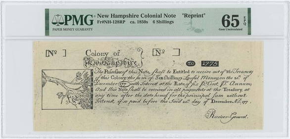
1775 New Hampshire 6 Shilling NH-128 PMG GEM65 EPQ c.1850 Cohen Paul RevereMynt Auctions4.6(680)See Sold PriceMar 01, 2024
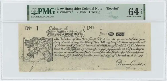
1775 New Hampshire 1 Shilling NH-127 PMG CU 64 EPQ c.1850 Cohen Paul RevereMynt Auctions4.6(680)See Sold PriceMar 01, 2024
1750 Bowen Map of Bermuda and St. Kitts -- A New & Accurate Map of Bermudas or Sommer's Islands...Jasper524.5(9.8k)See Sold PriceFeb 27, 2024
Two Hand-Colored 19th Century Maps of New Orleans and Louisiana, Larger- H.- 12 1/2 in., W.- 15 1/2Crescent City Auction Gallery4.3(229)See Sold PriceMar 08, 2024
(11) various early & middle 20th c booksWilliam Bunch Auctions & Appraisals4.6(876)See Sold PriceFeb 27, 2024
English/Scottish Bas Relief Carved Oval Plaques 19th C., H 17.75" W 12.25" 1 PairDuMouchelles4.6(825)See Sold PriceMar 14, 2024


![[Tintype] Massive Bowie knife (1 of 1)](https://p1.liveauctioneers.com/7226/317626/170485482_1_x.jpg?height=282&quality=70&version=1706368022)
![[Ambrotype] Magnificent Portrait (1 of 1)](https://p1.liveauctioneers.com/7226/317626/170485477_1_x.jpg?height=282&quality=70&version=1706368022)


![[Tintype] Native American Man w/ Knife (1 of 2)](https://p1.liveauctioneers.com/7226/317626/170485453_1_x.jpg?height=282&quality=70&version=1706368022)
![[REES, Charles] Enlistedman w/ Bowie Knife (1 of 1)](https://p1.liveauctioneers.com/7226/317626/170485489_1_x.jpg?height=282&quality=70&version=1706368022)
![[Ambrotype] Wounded at Gettysburg (1 of 1)](https://p1.liveauctioneers.com/7226/317626/170485471_1_x.jpg?height=282&quality=70&version=1706368022)


![[Ambrotype] Young Soldier w/ Bowie Knife (1 of 1)](https://p1.liveauctioneers.com/7226/317626/170485459_1_x.jpg?height=282&quality=70&version=1706368022)

![[Daguerreotype] Soldier w/ Bowie Knife (1 of 2)](https://p1.liveauctioneers.com/7226/317626/170485458_1_x.jpg?height=282&quality=70&version=1706368022)
![[Tintype] Soldier w/ Flowers (1 of 1)](https://p1.liveauctioneers.com/7226/317626/170485495_1_x.jpg?height=282&quality=70&version=1706368022)
![[Tintype] Identified North Carolina Infantryman (1 of 2)](https://p1.liveauctioneers.com/7226/317626/170485474_1_x.jpg?height=282&quality=70&version=1706368022)


![[CLIPPER SHIP CARD]. New Zealand Neal & Crown in Shield Aus... (1 of 2)](https://p1.liveauctioneers.com/928/318880/171360960_1_x.jpg?height=282&quality=70&version=1707501302)