Marc Chagall-Limited Edition -Paris Opera Ceiling after ChagallArt Legacy Auctions4.5(223)See Sold PriceFeb 24, 2024
Salvador Dali Pantagruel Limited Edition Lithograph Hand signed and numberedArt Legacy Auctions4.5(223)See Sold PriceFeb 24, 2024
Pablo Picasso Bouquet of Peace Collection Domaine Picasso Limited Edition on paper.Art Legacy Auctions4.5(223)See Sold PriceFeb 24, 2024
A RARE MAXFIELD PARRISH JACK AND THE BEANSTALK PRINTSoulis Auctions4.8(953)See Sold PriceFeb 24, 2024
LARGE MECHANICAL PRINT 'STARS' AFTER MAXFIELD PARRISHSoulis Auctions4.8(953)See Sold PriceFeb 24, 2024
Heinrich Aldegrever, etc. 15 old master prints. 16th-17th centuries. Aldegrever works include "ManTremont Auctions4.5(297)See Sold PriceFeb 25, 2024
SoldBryce, James 1881 Map of South USA. Texas, Florida, etcLithograph Map Published 1881, London for ""The International Atlas and Geography..." by James Bryce. Maps by Edward Weller & John Bartholomew. Uncommon. Paper Size: 18 x 13 inch (46 x 33cm) Good CondSee Sold Price
SoldBryce, James 1881 Map of Western USA. California etcLithograph Map Published 1881, London for ""The International Atlas and Geography..." by James Bryce. Maps by Edward Weller & John Bartholomew. Uncommon. Paper Size: 18 x 13 inch (46 x 33cm) Good CondSee Sold Price
Bryce, James 1881 Map of Western USA. California etcLithograph Map Published 1881, London for ""The International Atlas and Geography..." by James Bryce. Maps by Edward Weller & John Bartholomew. Uncommon. Paper Size: 18 x 13 inch (46 x 33cm) Good CondSee Sold Price
Bryce, James 1881 Map of Western USA. California etcLithograph Map Published 1881, London for ""The International Atlas and Geography..." by James Bryce. Maps by Edward Weller & John Bartholomew. Uncommon. Paper Size: 18 x 13 inch (46 x 33cm) Good CondSee Sold Price
Bryce, James 1881 Map of Western USA. California etcLithograph Map Published 1881, London for ""The International Atlas and Geography..." by James Bryce. Maps by Edward Weller & John Bartholomew. Uncommon. Paper Size: 18 x 13 inch (46 x 33cm) Good CondSee Sold Price
SoldBryce, James 1881 Map of USA Border StatesIncl Ohio, Kentucky, Virginia, W. Virginia, Maryland, Tennessee & N. Carolina. Lithograph Map Published 1881, London for ""The International Atlas and Geography..." by James Bryce. Maps by Edward WellSee Sold Price
SoldBryce, James 1881 Map of South AustraliaLithograph Map Published 1881, London for ""The International Atlas and Geography..." by James Bryce. Maps by Edward Weller & John Bartholomew. Uncommon. Paper Size: 18 x 13 inch (46 x 33cm) Good CondSee Sold Price
Bryce, James 1881 Map of South AustraliaLithograph Map Published 1881, London for ""The International Atlas and Geography..." by James Bryce. Maps by Edward Weller & John Bartholomew. Uncommon. Paper Size: 18 x 13 inch (46 x 33cm) Good CondSee Sold Price
Bryce, James 1881 Map of USA Border StatesIncl Ohio, Kentucky, Virginia, W. Virginia, Maryland, Tennessee & N. Carolina. Lithograph Map Published 1881, London for ""The International Atlas and Geography..." by James Bryce. Maps by Edward WellSee Sold Price
Bryce, James 1881 Map of USA Border StatesIncl Ohio, Kentucky, Virginia, W. Virginia, Maryland, Tennessee & N. Carolina. Lithograph Map Published 1881, London for ""The International Atlas and Geography..." by James Bryce. Maps by Edward WellSee Sold Price
SoldBryce, James 1881 Map of New South Wales, AustraliaLithograph Map Published 1881, London for ""The International Atlas and Geography..." by James Bryce. Maps by Edward Weller & John Bartholomew. Uncommon. Paper Size: 18 x 13 inch (46 x 33cm) Good CondSee Sold Price
Bryce, James 1881 Map of New South Wales, AustraliaLithograph Map Published 1881, London for ""The International Atlas and Geography..." by James Bryce. Maps by Edward Weller & John Bartholomew. Uncommon. Paper Size: 18 x 13 inch (46 x 33cm) Good CondSee Sold Price
Bryce, James 1881 Map of New South Wales, AustraliaLithograph Map Published 1881, London for ""The International Atlas and Geography..." by James Bryce. Maps by Edward Weller & John Bartholomew. Uncommon. Paper Size: 18 x 13 inch (46 x 33cm) Good CondSee Sold Price
SoldBryce, James 1881 Map of New Zealand South IslandLithograph Map Published 1881, London for ""The International Atlas and Geography..." by James Bryce. Maps by Edward Weller & John Bartholomew. Uncommon. Paper Size: 18 x 13 inch (46 x 33cm) Good CondSee Sold Price
Bryce, James 1881 Group of 3 Maps. South AmericaLithographs Map Published 1881, London for ""The International Atlas and Geography..." by James Bryce. Maps by Edward Weller & John Bartholomew. Uncommon. Paper Size: 18 x 13 inch (46 x 33cm) Good ConSee Sold Price
SoldBryce, James 1881 Group of 3 Maps. South AmericaLithograph Maps Published 1881, London for ""The International Atlas and Geography..." by James Bryce. Maps by Edward Weller & John Bartholomew. Uncommon. Paper Size: 18 x 13 inch (46 x 33cm) Good ConSee Sold Price
Bryce, James 1881 Pair of Maps of USA East Coast"Middle States. New York, Pennsylvannia, New Jersey, Delaware and Maryland" and "New England States. Maine, New Hampshire, Vermont, Massachusetts, Rhode Island and Connecticut" Lithograph Maps PublishSee Sold Price
Bryce, James 1881 Pair of Maps of USA East Coast"Middle States. New York, Pennsylvannia, New Jersey, Delaware and Maryland" and "New England States. Maine, New Hampshire, Vermont, Massachusetts, Rhode Island and Connecticut" Lithograph Maps PublishSee Sold Price
Bryce, James 1881 Group of 3 Maps. South AmericaLithograph Maps Published 1881, London for ""The International Atlas and Geography..." by James Bryce. Maps by Edward Weller & John Bartholomew. Uncommon. Paper Size: 18 x 13 inch (46 x 33cm) Good ConSee Sold Price
SoldBryce, James 1881 Pair of Maps of the USA"Northern United States" and "United States" Lithograph Maps Published 1881, London for ""The International Atlas and Geography..." by James Bryce. Maps by Edward Weller & John Bartholomew. Uncommon.See Sold Price
SoldBryce, James 1881 Lot of 10 Maps of Canada & USADominion of Canada, North America, Middle States. New York, Pennsylvannia, New Jersey, Delaware and Maryland, New England States. Maine, New Hampshire, Vermont, Massachusetts, Rhode Island and ConnectSee Sold Price
Sold(19th c) NAUTICAL CHARTS and MAPS(12) James Imray London 1881 China and Japan, Australia and New Zealand, South Part of the North Sea, Coast of North American, Ports of India 1870, Laurie Coast of China, etc. Together with approx 1See Sold Price
SoldBryce, James 1881 Map of New ZealandLithograph Map Published 1881, London for ""The International Atlas and Geography..." by James Bryce. Maps by Edward Weller & John Bartholomew. Uncommon. Paper Size: 18 x 13 inch (46 x 33cm) Good CondSee Sold Price
SoldBryce, James 1881 Map of Islands. Singapore, Hong KongAlso Channel Islands, Malta, Malaysia, Gibraltar, and Aden. Lithograph Map Published 1881, London for ""The International Atlas and Geography..." by James Bryce. Maps by Edward Weller & John BartholomSee Sold Price
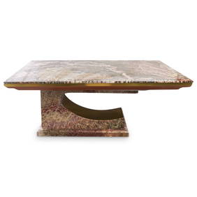
Paul Puccio (b. 1934) Brass & Multi Colored Onyx Extension Dining TableAkiba Galleries4.7(1.8k)See Sold PriceFeb 29, 2024
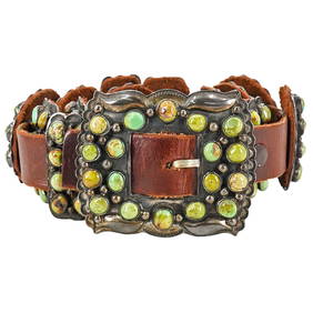
Vintage DM Begay Navajo Sterling Silver and Turquoise Concho BeltAkiba Galleries4.7(1.8k)See Sold PriceFeb 29, 2024
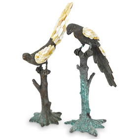
Maitland-Smith Bronze & Mother Of Pearl Parrot SculpturesAkiba Galleries4.7(1.8k)See Sold PriceFeb 29, 2024
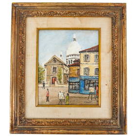
After Elisee Maclet (French, 1881-1962) Oil on Canvas PaintingAkiba Galleries4.7(1.8k)See Sold PriceFeb 29, 2024
Cindy Sherman (American, b. 1954) Abstract Silver Gelatin PhotographAkiba Galleries4.7(1.8k)See Sold PriceFeb 29, 2024
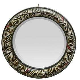
Large Mid Century Geometric Abstract Oil on Canvas PaintingAkiba Galleries4.7(1.8k)See Sold PriceFeb 29, 2024
(4 Pc) Tiffany and Co. Crystal Decanters With Silver Plated TrayAkiba Galleries4.7(1.8k)See Sold PriceFeb 29, 2024
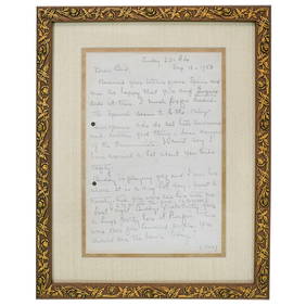
Autograph Of Personal Letter From Mary Pickford To "Bud"Akiba Galleries4.7(1.8k)See Sold PriceFeb 29, 2024
1683 Sanson Map of the Caribbean -- Les Isles Antilles, &c Entre Lesquelles sont les Lucayes, et lesJasper524.5(9.9k)See Sold PriceFeb 27, 2024