LOT OF 8 1767 VITRUVIUS BRITANNICUS ARCHITECTURAL ENGRAVINGSMarnie Collection Auction4.5(70)See Sold PriceMar 10, 2024
Francis Bacon (British, 1909-1992) Offset Lithograph in Colors, Ca. 1980, "Portrait of IsabelDuMouchelles4.6(833)See Sold PriceMar 15, 2024
After Sir David Wilkie (British, 1785-1841) Engraving on Paper, Ca. 1832, "The Penny Wedding", H 16"DuMouchelles4.6(833)See Sold PriceMar 15, 2024
ORIGINAL ANTIQUE ARCHITECTURAL ENGRAVING VITRUVIUS BRITANNICUSMarnie Collection Auction4.5(70)See Sold PriceMar 10, 2024
ORIGINAL ANTIQUE ARCHITECTURAL ENGRAVING VITRUVIUS BRITANNICUSMarnie Collection Auction4.5(70)See Sold PriceMar 10, 2024
Phillip Sutton (British, B. 1928) Woodcut 1969, "Edna", H 18" W 17.75"DuMouchelles4.6(833)See Sold PriceMar 15, 2024
Michael Challenger (British, B. 1939) Lithograph 1969, "Lunar Tables", H 12" W 19"DuMouchelles4.6(833)See Sold PriceMar 15, 2024
SoldBryce, James 1881 Lot of 3 Maps of the British IslesEngland & Wales, Scotland and Physical Map of the British Isles. Lithograph Maps Published 1881, London for ""The International Atlas and Geography..." by James Bryce. Maps by Edward Weller & John BarSee Sold Price
SoldBryce, James 1881 Lot of 4 Maps of the UK, ScotlandIncl England/Wales, British Isles and Scotland. Lithograph Maps Published 1881, London for ""The International Atlas and Geography..." by James Bryce. Maps by Edward Weller & John Bartholomew. UncommoSee Sold Price
SoldBryce, James 1881 Lot 3 Maps World. Temperature, BirdsIncl 2 Temperature Maps and one showing the distribution of Birds and Fish. Lithograph Maps Published 1881, London for ""The International Atlas and Geography..." by James Bryce. Maps by Edward WellerSee Sold Price
Bryce, James 1881 Lot 3 Maps World. Temperature, BirdsIncl 2 Temperature Maps and one showing the distribution of Birds and Fish. Lithograph Maps Published 1881, London for ""The International Atlas and Geography..." by James Bryce. Maps by Edward WellerSee Sold Price
SoldBryce, James 1881 Pair of Maps England/Wales & ScotlandEngland & Wales, Scotland and Physical Map of the British Isles. Lithograph Maps Published 1881, London for ""The International Atlas and Geography..." by James Bryce. Maps by Edward Weller & John BarSee Sold Price
SoldBryce, James 1881 Group of 3 Maps. Roman EmpireLithographs Map Published 1881, London for ""The International Atlas and Geography..." by James Bryce. Maps by Edward Weller & John Bartholomew. Uncommon. Paper Size: 13.5 x 10 inch (34 x 25cm) and 18See Sold Price
SoldBryce, James 1881 Group of 3 Maps of The Middle East"Palestine and Phoenicia" with unrelated map of Gallia on same sheet. "Palestine" and "Persia Afghanistan & Beloochistan" Lithograph Maps Published 1881, London for ""The International Atlas and GeogrSee Sold Price
SoldBryce, James 1881 Lot of 10 Maps of Canada & USADominion of Canada, North America, Middle States. New York, Pennsylvannia, New Jersey, Delaware and Maryland, New England States. Maine, New Hampshire, Vermont, Massachusetts, Rhode Island and ConnectSee Sold Price
SoldBryce, James 1881 Lot of 10 Maps of EuropeIncl Turkey in Europe, Austria-Hungary, German Empire, Denmark, Denmark, German Empire, Switzerland, France, Hispania/Germania, Italia, Sweden/Norway. Lithograph Maps Published 1881, London for ""TheSee Sold Price
SoldBryce, James 1881 Group of 3 Maps. South AmericaLithograph Maps Published 1881, London for ""The International Atlas and Geography..." by James Bryce. Maps by Edward Weller & John Bartholomew. Uncommon. Paper Size: 18 x 13 inch (46 x 33cm) Good ConSee Sold Price
Bryce, James 1881 Group of 3 Maps. South AmericaLithographs Map Published 1881, London for ""The International Atlas and Geography..." by James Bryce. Maps by Edward Weller & John Bartholomew. Uncommon. Paper Size: 18 x 13 inch (46 x 33cm) Good ConSee Sold Price
SoldBryce, James 1881 Mixed Lot of European MapsIncl Europe Continent, Britain under Saxons/Romans, Russia, Italy, Spain/Portugal, Swtizerland, Holland/Belgium, and France. Lithograph Maps Published 1881, London for ""The International Atlas and GeSee Sold Price
SoldBartholomew, John 1904 Lot of 3 Maps of ScotlandIncl Density of Population Central Scotland, Parliamentary Representation of Scotland, and Glasgow City Plan. Lithograph Maps Published 1904, London for "The Survey Gazetteer of the British Isles" UncSee Sold Price
SoldBartholomew, John 1904 Lot of 3 British MapsIncl Death Rates and Religions. Lithograph Maps Published 1904, London for "The Survey Gazetteer of the British Isles" Uncommon First Edition by John Bartholomew. Paper Size: 10 x 7 inch (25 x 18cm) GSee Sold Price
Sold[POCKET MAPS] A lot of 3 engraved maps[POCKET MAPS] Lot of 3 engraved maps, each dissected and mounted to linen, including: W.H. Smith & Son's. "Railway Map of the BritishIsles." London. Blue cloth binding. ** "New Coloured Chart of ThameSee Sold Price
SoldMoule, Thomas C1850 Lot of 3 British Maps. YorkshireIncl North Riding, West Riding, and East Riding. Steel Engraved Map Published C1850 "A Complete and Universal English Dictionary" by the Rev. James Barclay et al. Maps by Thomas Moule. Paper Size: 10.See Sold Price
Bryce, James 1881 Set of 6 Maps of CanadaIncl Manitoba, British Columbia, North West Territory, Ontario, Quebec, and New Brunswick/Nova Scotia. Lithograph Maps Published 1881, London for ""The International Atlas and Geography..." by James BSee Sold Price
Bryce, James 1881 Set of 6 Maps of CanadaIncl Manitoba, British Columbia, North West Territory, Ontario, Quebec, and New Brunswick/Nova Scotia. Lithograph Maps Published 1881, London for ""The International Atlas and Geography..." by James BSee Sold Price
Bryce, James 1881 Set of 6 Maps of CanadaIncl Manitoba, British Columbia, North West Territory, Ontario, Quebec, and New Brunswick/Nova Scotia. Lithograph Maps Published 1881, London for ""The International Atlas and Geography..." by James BSee Sold Price
Sold5 Maps, British Isles, Misc. Publishers, c.1762-1805LOT. 5 maps relating to the British Isles, various publishers, c.1762-1805, includes: Kitchin. Ireland with the Roads, from the latest Surveys. 36.7x34 cm. (Some offsetting, 3" tear near centerfold.)See Sold Price
Sold5 Maps, British Isles, Misc. Publishers, c.1762-18LOT. 5 maps relating to the British Isles, various publishers, c.1762-1805, includes: Kitchin. Ireland with the Roads, from the latest Surveys. 36.7x34 cm. (Some offsetting, 3" tear near centerfold.)See Sold Price
Map of the British Isles, 1830Map: British Isles Maker: Longman, Rees, Orme, Brown and Green, Sydney Hall Date: 1830 Size: Folio, 20.25 inches high x 16.3 inches wide Please note that this lot has a reserve. When you leave a bid iSee Sold Price
Maps of Britain and IrelandTitle: Lot of 5 maps relating to the British Isles Author: ** Description: Includes: Kitchin. Ireland with the Roads, from the latest Surveys. 36.7x34 cm. (Some offsetting, 3" tear near centerfold.) cSee Sold Price
SoldBryce, James 1881 Map of New ZealandLithograph Map Published 1881, London for ""The International Atlas and Geography..." by James Bryce. Maps by Edward Weller & John Bartholomew. Uncommon. Paper Size: 18 x 13 inch (46 x 33cm) Good CondSee Sold Price
Northern Pacific RR 17th Annual Report-Version 1-September 15, 1881JM Hobby Supply and Railroad Artifact Auctions4.4(127)See Sold PriceFeb 24, 2024
Northern Pacific RR 17th Annual Report-Version 2-September 15, 1881JM Hobby Supply and Railroad Artifact Auctions4.4(127)See Sold PriceFeb 24, 2024
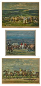
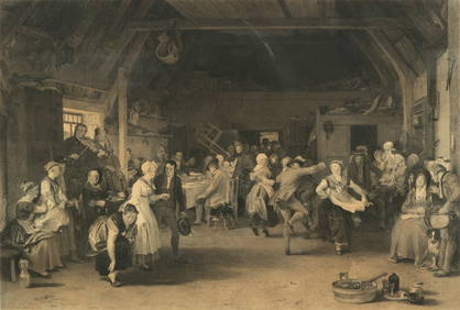
Walter Charles Horsley (UK,1855-1921) oil painting antiqueBroward Auction Gallery4.7(300)See Sold PriceMar 31, 2024
LATE 17TH C. FRENCH MAP OF THE NEW WORLD BY ALEXIS-HUBERT JAILLOT (1632-1712)Thomaston Place Auction Galleries4.4(394)See Sold PriceFeb 24, 2024
James Ensor (Belgian, 1860-1949) - Le Luminisme, Le Futurisme, La Gravure à L'Eau-Forte (LaFreeman's | Hindman4.5(158)See Sold PriceFeb 27, 2024
Lucian Freud (British, 1922-2011) - Head of a ChildFreeman's | Hindman4.5(158)See Sold PriceFeb 27, 2024
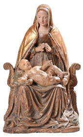
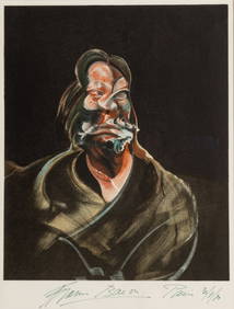
Bernard Meadows (British, 1915-2005) - Four Small Reliefs on Cock ThemeFreeman's | Hindman4.5(158)See Sold PriceFeb 28, 2024
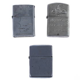
WWII Korea & Vietnam Era Silver Lighters 3pc LOTHill Auction Gallery 4.7(1k)See Sold PriceFeb 28, 2024
Chatelain - 3 Maps of the British Isles (England, Ireland, Scotland)Trillium Antique Prints & Rare Books4.5(33)See Sold PriceFeb 24, 2024
JAMES BOND: GOLDFINGER (1964) - Auric Goldfinger's (Gert Frobe) Jetstar Jet WindowPropstore4.3(7)See Sold PriceMar 12, 2024
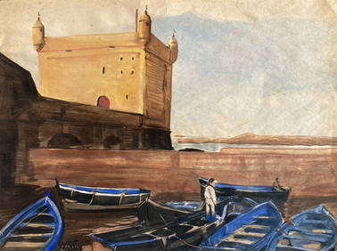
Map: A 17thC engraved map of the British Isles titled A Generall Mapp of the Isles of GreatClaydon Auctioneers Ltd4.3(125)See Sold PriceFeb 26, 2024
FINDING NEVERLAND (2004) - Sir James Matthew Barrie's (Johnny Depp) SwordPropstore4.3(7)See Sold PriceMar 13, 2024
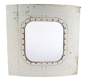
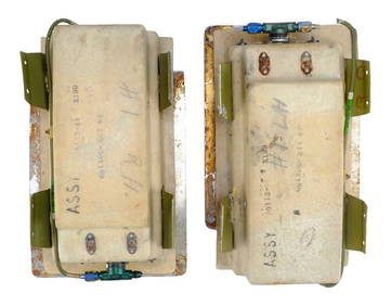
JAMES BOND: GOLDFINGER (1964) - Pair of Auric Goldfinger's (Gert Frobe) Jetstar Jet Oxygen MaskPropstore4.3(7)See Sold PriceMar 13, 2024
James Gillray, "Uncle Toby Retired..."Old Kinderhook Auction Company4.6(217)See Sold PriceMar 05, 2024
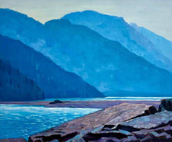
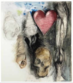
20" x 23 3/4" - Original Acrylic On Canvas Of Bear River At Stewart, British ColumbiaWeatherham Estate Treasures3.9(159)See Sold PriceMar 21, 2024
1800s James Dromgole LINTON Antique Etching Surprise Signed FramedKCM Galleries4.7(164)See Sold PriceFeb 25, 2024
Jim (James) Dine (AMERICAN / NEW YORK / OHIO, Born 1935)Joshua Kodner4.2(395)See Sold PriceMar 09, 2024
Herman Moll A New Map of Ye North Parts of AmericaWillow Auction House4.5(292)See Sold PriceMar 14, 2024
JJ Audubon 19C 3 Vols Quadrupeds North American Bowen Illus Full Leather v1-3 Gilt SetHess Fine Auctions4.5(213)See Sold PriceMar 02, 2024


![[POCKET MAPS] A lot of 3 engraved maps (1 of 2)](https://p1.liveauctioneers.com/1124/187577/94368885_1_x.jpg?height=282&quality=70&version=1607095126)