LOT OF 8 1767 VITRUVIUS BRITANNICUS ARCHITECTURAL ENGRAVINGSMarnie Collection Auction4.5(70)See Sold PriceMar 10, 2024
Francis Bacon (British, 1909-1992) Offset Lithograph in Colors, Ca. 1980, "Portrait of IsabelDuMouchelles4.6(830)See Sold PriceMar 15, 2024
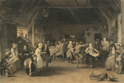
After Sir David Wilkie (British, 1785-1841) Engraving on Paper, Ca. 1832, "The Penny Wedding", H 16"DuMouchelles4.6(830)See Sold PriceMar 15, 2024
ORIGINAL ANTIQUE ARCHITECTURAL ENGRAVING VITRUVIUS BRITANNICUSMarnie Collection Auction4.5(70)See Sold PriceMar 10, 2024
ORIGINAL ANTIQUE ARCHITECTURAL ENGRAVING VITRUVIUS BRITANNICUSMarnie Collection Auction4.5(70)See Sold PriceMar 10, 2024
Phillip Sutton (British, B. 1928) Woodcut 1969, "Edna", H 18" W 17.75"DuMouchelles4.6(830)See Sold PriceMar 15, 2024
Michael Challenger (British, B. 1939) Lithograph 1969, "Lunar Tables", H 12" W 19"DuMouchelles4.6(830)See Sold PriceMar 15, 2024
SoldBritish Isles.- Loader (T.B.) T.B. Loader's ScientificBritish Isles.- Loader (T.B.) T.B. Loader's Scientific and Commercial Map of England, and Wales; in which are Delineated the Canals, Rail-Roads & Navigable Rivers ... together with the Geology and PriSee Sold Price
SoldThe autographs of the 1953-54 New Zealand All BlacksThe autographs of the 1953-54 New Zealand All Blacks Rugby touring team to the British Isles, the signatures of the 30-man playing squad on a pre-prepared sheet of paper, Scott, Loader, Dixon, Wilson,See Sold Price
SoldT.B. Appelton, British Late 19th C. EngravingAfter Heywood Hardy (British, 1843-1933), hand colored engraving by T.B. Appleton, and published in London in 1889. Engraving depicts a young woman fallen onto the lap of an older gentlemen in a postuSee Sold Price
SoldWWII BRITISH BREN LMG .303 BRIT PAN MAG & LOADERWWII BRITISH BREN LMG .303 BRIT PAN MAG & LOADER 2 WWII British Bren LMG .303 British pan magazines. Size / Gauge: .303 BritishSee Sold Price
SoldT.B. HARDY SIGNED BRITISH PORT WATERCOLOR PAINTNGThomas Bush Hardy (British, 1842-1897) watercolor on paper, signed lower left "T.B. Hardy" and titled "Portside Calais." Dimensions inside frame: 8"H. x 13.75"W. Ht: 19" Width: 24.5"See Sold Price
SoldT.B. Winter Surveyor's CompassEnglish. Newcastle on Tyne. 1880s. Brass. T.B. Winter. Dial marked, "T.B. Winter 55 Grey St. Newcastle on Tyne". 14" long. Compass box 6.25". Retained in original mahogany case. Est. $200 - 300See Sold Price
SoldMatchbox Moko Prime Mover Low LoaderMatchbox Moko large scale Prime Mover Low Loader Trailer and Caterpillar Bulldozer "British Road Services" - orange, green engine covers, grey wheels, Trailer is finished in blue including ramps - oveSee Sold Price
G. (British crown) Rifle 1850s JMD-11975G. (British crown).77, swivel musket, rare design, barrel length 37.5", breech loader, possibly one of the first breech loader muskets. Leaf target sights. SN: N/A, JMD Oval Tag: 6881, Condition: GoodSee Sold Price
SoldA Victorian walnut mercury stick barometer T.BA Victorian walnut mercury stick barometer T.B. Winter, Newcastle, late 19th century With cavetto moulded caddy pediment above rectangular bevel-glazed double canted ivory scales flanking tube each caSee Sold Price
Victorian silver desk stand with cut glass inkwell, T.BVictorian silver desk stand with cut glass inkwell, T.B J.H Sheffield 1886, 26cm in length, approximate weight 336.0gSee Sold Price
4 ENGLISH ISSUE DINKY TRUCKS 986 LOW LOADER 2834 Dinky English Issue Trucks to include # 986 Thornecroft Mighty Antar & Low Loader trailer with skid & prop, Believed to be reproduction, #283 British Overseas Airways bus, EveReady GUY box truck, anSee Sold Price
Harbor scene after T.B. Hardy,Harbor scene after T.B. Hardy, manner of Thomas Bush Hardy, British, 1842-1897, sailing vessels, unsigned, watercolor on paper, laid down, browning, foxing, two possible paper repairs, tape residue atSee Sold Price
SoldLoader (T.B.) and J.Ashton, - publishers . Thepublishers . The Illustrated Atlas of Ancient and Modern Geography , engraved title, 19 double-page sheets of maps, sections , mostly hand-coloured, 1 plate, original straight-grain morocco, worn, hinSee Sold Price
SoldTHE ILLUSTRATED ATLAS OF ANCIENT AND MODERNThe Illustrated Atlas of Ancient and Modern Geography, Science, Commerce and Statistics, London: T.B. Loader & J. Ashton c.1844, complete with coloured maps and diagrams (63pp), 42.5 x 35cm approx sheSee Sold Price
SoldTOBIAS LOTTER MAP OF BRITISH ISLESOriginal hand-colored engraving. 18th century. Three different hand-colored heraldic devices. Dimensions: (Frame) H 30.5" x W 26.5", (Sight) H 23.75" x W 20" Condition: Some light foxing. Unexamined oSee Sold Price
British Isles, Pieter Goos 1665-66Title: Pas-Caart vant Canaal Vertoonende in 't Gheheel Engelandt, Schotlandt, Yrlandt, en een Gedeelte van Vrancryck Subject: British Isles Maker: Pieter Goos Date: 1665-66, Amsterdam Materials: HandSee Sold Price
Sold1889 1ed ZigZag Journeys British Isles Liverpool Lands End London Bridge CASTLES1889 1ed ZigZag Journeys British Isles Liverpool Lands End London Bridge CASTLES American author Hezekiah Butterworth is best remembered for his enormous, seventeen volume work Zig-Zag Journeys. WrittSee Sold Price
Sold1695 Morden Map of the British Isles in Roman Times --Title/Content of Map: 1695 Morden Map of the British Isles in Roman Times -- Britannia Romana Date: 1695, London Cartographer: R Morden Size: 14 X 16.8 in. This is a handsome map of the British IslesSee Sold Price
Sold1796 MAP OF THE BRITISH ISLESItalian map. Caleographia Camerale. Engraving. Dimensions: (Frame) H 22.25"x W 16.75", (Sight) H 21.25" x W 15.75" Condition: Some creases to paper.See Sold Price
Janssonius: Sea Chart of British Isles, Gold Leaf, 1660Title: Pascaart vant Canaal, Tusschen Engelant en Vrancryck, alsmede ge heel Ierlant en Schotlant Map maker: J. Janssonius, Atlantis Majoris Quinta Pars Orbem Maritimum Place and Year: Amsterdam, 1660See Sold Price
Bonne: Antique Map of the British Isles, 1780TITLE/CONTENT OF MAP: 'Carte Des Isles Britanniques contenant les Royaumes d'Angleterre, d'Ecosse et d'Irlande' A map of the British Isles DATE PRINTED: 1780 IMAGE SIZE: Approx 34.5 x 23.0cm, 13.5 x 9See Sold Price
Bonne: Antique Map of the British Isles, 1780Title/Content of Map: 'Carte Des Isles Britanniques contenant les Royaumes d'Angleterre, d'Ecosse et d'Irlande'. A map of the British Isles Date Printed: 1780 Image Size: Approx 34.5 x 23.0cm, 13.5 xSee Sold Price
SoldTallis, John (Pub) 1852 Map. British IslesSteel Engraved Map with Original Outline Hand Color Published 1852-56 by John Tallis, London for "The Universal Pronouncing Dictionary" by Thomas Wright. Drawn & Engraved by John Rapkin. Centre fold aSee Sold Price
SoldEARLY 19th c. OIL ON BOARD BRITISH ISLESAntique early 19th c. Oil on Board of a Coastal Castle Vista. Very well done and professionally framed in a gilt wood carved frame by Moormans Gallery. The painting does have some minor age appropriatSee Sold Price
LATE 17TH C. FRENCH MAP OF THE NEW WORLD BY ALEXIS-HUBERT JAILLOT (1632-1712)Thomaston Place Auction Galleries4.4(393)See Sold PriceFeb 24, 2024
ATTR TO LIBERTY COMPANY ARTS CRAFTS COPPER MIRRORAntique Arena Inc.4.5(878)See Sold PriceFeb 24, 2024
ARTS AND CRAFTS HAMMERED LAMP BY FREDRICK FIFIELDAntique Arena Inc.4.5(878)See Sold PriceFeb 24, 2024
AN ANTIQUE FOLDING MAP OF THE BRITISH ISLES DATED 1873Hutchinson Scott Auctioneers4.4(42)See Sold PriceFeb 28, 2024
Chatelain - 3 Maps of the British Isles (England, Ireland, Scotland)Trillium Antique Prints & Rare Books4.5(32)See Sold PriceFeb 24, 2024
De Jode, Rare, pub. 1593 - Map of the British Isles [England, Scotland, Ireland] (Angliae Scotiae etTrillium Antique Prints & Rare Books4.5(32)See Sold PriceFeb 24, 2024
Donovan's The Natural History of British Shells - 5 Volumes in 3 Books with 180 EngravingsTrillium Antique Prints & Rare Books4.5(32)See Sold PriceFeb 24, 2024
Map: A 17thC engraved map of the British Isles titled A Generall Mapp of the Isles of GreatClaydon Auctioneers Ltd4.3(125)See Sold PriceFeb 26, 2024
Stanford, Edward 1901 Large Map. Geological Map of the British IslesAlbion Auctions4.7(341)See Sold PriceMar 01, 2024
Stanford, Edward 1901 Large Map. Hydrographical Map of the British IslesAlbion Auctions4.7(341)See Sold PriceMar 01, 2024
Stanford, Edward 1901 Large Map. Stereographical Map of The British IslesAlbion Auctions4.7(341)See Sold PriceMar 01, 2024
Paterson & Mogg 1822 Pair of British Road Maps. Isle of Thanet & WightAlbion Auctions4.7(341)See Sold PriceMar 01, 2024
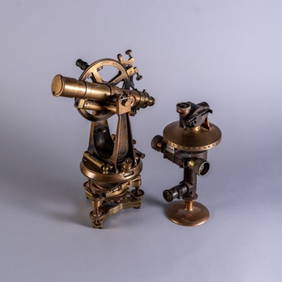
TWO BRITISH BRASS SCIENTIFIC INSTRUMENTSPridham's Auctions & Appraisals4.7(223)See Sold PriceMar 02, 2024


![De Jode, Rare, pub. 1593 - Map of the British Isles [England, Scotland, Ireland] (Angliae Scotiae et (1 of 2)](https://p1.liveauctioneers.com/6581/319571/171593327_1_x.jpg?height=282&quality=70&version=1707853304)