Vintage Ca. 1940's International Panel Delivery Truck Converted into Stationary Food Truck, WasSwisher Bros. Auction LLC4.4(241)See Sold PriceFeb 25, 2024
Martin Custom Acoustic Guitar 000 Body Style Rosewood with Hard CaseHess Fine Auctions4.5(197)See Sold PriceMar 02, 2024
1968 Gibson LG-0 Acoustic Dreadnought Parlor GuitarHess Fine Auctions4.5(197)See Sold PriceMar 02, 2024
Replica Robinson 1862 Sharps CarbineSchmidt's Antiques Inc. Since 19114.8(431)See Sold PriceMar 02, 2024
PAIR (18th c) OF FLINTLOCK DUELING PISTOLSJohn McInnis Auctioneers,LLC4.6(502)See Sold PriceFeb 24, 2024
PAIR T KETLAND of LONDON .60 CAL FLINTLOCK PISTOLSJohn McInnis Auctioneers,LLC4.6(502)See Sold PriceFeb 25, 2024
Gibson ES335 Semi Hollow Vintage Sunburst Electric Guitar with Certificate of Authenticity Hand MadeHess Fine Auctions4.5(197)See Sold PriceMar 02, 2024
WALT DISNEY WORLD - Figment Animatronic Character Skin from EPCOT's Journey Into ImaginationPropstore4.2(6)See Sold PriceMar 12, 2024
Lot Of 3 Early Large Three-Ring Binders Full Of Thousands Of StampsRbfinearts4.4(571)See Sold PriceFeb 24, 2024
A FINE PERSIAN MALAYER PRAYER RUG WITH CYPRESS C. 1860Soulis Auctions4.8(953)See Sold PriceFeb 24, 2024
Thomas Hart Benton; 20thC. American Regionalist Oil SignedMid-Hudson Auction Galleries4.4(468)See Sold PriceFeb 24, 2024
Fender USA Stratocaster Electric Guitar Classic Candy Red and White Original Stickers with Gig BagHess Fine Auctions4.5(197)See Sold PriceMar 02, 2024
1986 Fender Stratocaster Japan Blue-Green with White Pickguard and Gig Bag JapaneseHess Fine Auctions4.5(197)See Sold PriceMar 02, 2024
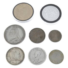
SoldBritish commercial tokens (15)British commercial tokens, halfpennies, D. Eccleston, Lancaster, 1794, Wm. Rusher, Banbury, undated, Robert Bird Wilkins, Isle of Wight, 1792, Coventry, 'Arms' Series, 1797 (2), 'W. Pitt', Dover, 1794See Sold Price
SoldTOBIAS LOTTER MAP OF BRITISH ISLESOriginal hand-colored engraving. 18th century. Three different hand-colored heraldic devices. Dimensions: (Frame) H 30.5" x W 26.5", (Sight) H 23.75" x W 20" Condition: Some light foxing. Unexamined oSee Sold Price
British Isles, Pieter Goos 1665-66Title: Pas-Caart vant Canaal Vertoonende in 't Gheheel Engelandt, Schotlandt, Yrlandt, en een Gedeelte van Vrancryck Subject: British Isles Maker: Pieter Goos Date: 1665-66, Amsterdam Materials: HandSee Sold Price
Sold1889 1ed ZigZag Journeys British Isles Liverpool Lands End London Bridge CASTLES1889 1ed ZigZag Journeys British Isles Liverpool Lands End London Bridge CASTLES American author Hezekiah Butterworth is best remembered for his enormous, seventeen volume work Zig-Zag Journeys. WrittSee Sold Price
Sold1695 Morden Map of the British Isles in Roman Times --Title/Content of Map: 1695 Morden Map of the British Isles in Roman Times -- Britannia Romana Date: 1695, London Cartographer: R Morden Size: 14 X 16.8 in. This is a handsome map of the British IslesSee Sold Price
Sold1796 MAP OF THE BRITISH ISLESItalian map. Caleographia Camerale. Engraving. Dimensions: (Frame) H 22.25"x W 16.75", (Sight) H 21.25" x W 15.75" Condition: Some creases to paper.See Sold Price
SoldATTR: WILLIAM KIDD (BRITISH 1792 -1863)Untitled (two girls resting) Oil on canvas, signed lower right.Dimensions:H 18.5" W 24"Condition: poor, surface dirt, holes to the canvas,loss paint and off from the canvas.Note: All items are sold asSee Sold Price
Janssonius: Sea Chart of British Isles, Gold Leaf, 1660Title: Pascaart vant Canaal, Tusschen Engelant en Vrancryck, alsmede ge heel Ierlant en Schotlant Map maker: J. Janssonius, Atlantis Majoris Quinta Pars Orbem Maritimum Place and Year: Amsterdam, 1660See Sold Price
Bonne: Antique Map of the British Isles, 1780TITLE/CONTENT OF MAP: 'Carte Des Isles Britanniques contenant les Royaumes d'Angleterre, d'Ecosse et d'Irlande' A map of the British Isles DATE PRINTED: 1780 IMAGE SIZE: Approx 34.5 x 23.0cm, 13.5 x 9See Sold Price
Bonne: Antique Map of the British Isles, 1780Title/Content of Map: 'Carte Des Isles Britanniques contenant les Royaumes d'Angleterre, d'Ecosse et d'Irlande'. A map of the British Isles Date Printed: 1780 Image Size: Approx 34.5 x 23.0cm, 13.5 xSee Sold Price
SoldTallis, John (Pub) 1852 Map. British IslesSteel Engraved Map with Original Outline Hand Color Published 1852-56 by John Tallis, London for "The Universal Pronouncing Dictionary" by Thomas Wright. Drawn & Engraved by John Rapkin. Centre fold aSee Sold Price
SoldEARLY 19th c. OIL ON BOARD BRITISH ISLESAntique early 19th c. Oil on Board of a Coastal Castle Vista. Very well done and professionally framed in a gilt wood carved frame by Moormans Gallery. The painting does have some minor age appropriatSee Sold Price
SoldClaudius Ptolemy's Map of the British IslesPublished 1599 AD. Taken from volume two of La Geografia di Claudio Tolomeo Alessandrino, Venice, translated by Girolamo Ruscelli and Gioseffo Rosaccio as 'Nuouamente tradotta di Greco in Italiano'; cSee Sold Price
SoldFamous Speed may of British IslesHeading: (Great Britaine) Author: Speed, John Title: The Kingdome of Great Britaine and Ireland Place Published: London Publisher:Roger Rea the Elder and younger Date Published: 1610-[1665]See Sold Price
SoldBritish Isles stoneware Ginger Beer bottlesBritish Isles stoneware Ginger Beer bottles (9 pcs)See Sold Price
SoldKeulen: Antique Map of the British Isles, 1678Map: British Isles Date Printed: 1678-1682 Cartographer: J Keulen Material/Medium: Paper Size: 21" x 24" Printed on thick paper. Double page map. Rare map of the British isles with north oriented to tSee Sold Price
SoldRalph Lauren British Isles Round Wicker TableCircular top on a quatrepartite pedestal base. Height 28 inches, diameter 48 inches. Notice to bidders: Condition reports and additional photographs are provided by request as a courtesy to our clientSee Sold Price
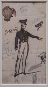
SoldGeorge Cruikshank (British, 1792 - 1878) Monk onGeorge Cruikshank (British, 1792 - 1878)Monk on Donkeyswatercolor on paperLeonard Clayton, New York label on back5 3/4" x 8 1/4"See Sold Price
SoldMaps of the British Isles, Plus, Lot of NineMaps of the British Isles, Plus, Lot of Nine Lot of eight maps of locations on the British Isles, including: British, ca. 1695. Robert Morden (British, 1650-1703), Cornwall. Title and artist identifieSee Sold Price
Jansson 1653 Map of British IslesDESCRIPTION: "Magnae Brittaniae et Hiberniae Nova Descriptio." Based on Willem Blaeu's 1631 map of the British Isles, this map depicts towns, rivers, an inset of Orkney Islands. Strap work cartouchesSee Sold Price
SoldBritish Isles stoneware Ginger Beer bottlesBritish Isles stoneware Ginger Beer bottles (10 pcs)See Sold Price
SoldBritish Isles Photographic Posters, Lot of FourIncluding See London's Great Museum of Ancient Treasure; Brighton; The Healing Waters of British Spas...; Lancashire... ca. 1930s printed The Travel and Industrial Development Association of GreatSee Sold Price
SoldBritish Isles Ginger Beer, Mineral Water bottlesBritish Isles Mineral Water, Ginger Beer bottles (15 pcs)See Sold Price
SoldMunster: Antique Ptolemaic Map of British Isles, 1570Title: Britannischen Insula. 1570 woodcut Ptolemaic map of the British Isles Map maker: Sebastian Münster Place and Year: Basel, 1570 Dimensions: 25.0 x 16.5 cm (9.8 x 6.5 in) Technique: Woodblock prSee Sold Price
LATE 17TH C. FRENCH MAP OF THE NEW WORLD BY ALEXIS-HUBERT JAILLOT (1632-1712)Thomaston Place Auction Galleries4.4(386)See Sold PriceFeb 24, 2024
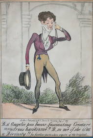
George Cruikshank (British 1792-1878) Caricature hand colored lithographGlobal Auctions Company4.3(36)See Sold PriceMar 03, 2024
ATTR TO LIBERTY COMPANY ARTS CRAFTS COPPER MIRRORAntique Arena Inc.4.5(852)See Sold PriceFeb 24, 2024
ARTS AND CRAFTS HAMMERED LAMP BY FREDRICK FIFIELDAntique Arena Inc.4.5(852)See Sold PriceFeb 24, 2024
AN ANTIQUE FOLDING MAP OF THE BRITISH ISLES DATED 1873Hutchinson Scott Auctioneers4.4(39)See Sold PriceFeb 28, 2024
Chatelain - 3 Maps of the British Isles (England, Ireland, Scotland)Trillium Antique Prints & Rare Books4.5(30)See Sold PriceFeb 24, 2024
De Jode, Rare, pub. 1593 - Map of the British Isles [England, Scotland, Ireland] (Angliae Scotiae etTrillium Antique Prints & Rare Books4.5(30)See Sold PriceFeb 24, 2024
Map: A 17thC engraved map of the British Isles titled A Generall Mapp of the Isles of GreatClaydon Auctioneers Ltd4.3(125)See Sold PriceFeb 26, 2024
Stanford, Edward 1901 Large Map. Geological Map of the British IslesAlbion Auctions4.6(336)See Sold PriceMar 01, 2024
Stanford, Edward 1901 Large Map. Hydrographical Map of the British IslesAlbion Auctions4.6(336)See Sold PriceMar 01, 2024
Stanford, Edward 1901 Large Map. Stereographical Map of The British IslesAlbion Auctions4.6(336)See Sold PriceMar 01, 2024
Paterson & Mogg 1822 Pair of British Road Maps. Isle of Thanet & WightAlbion Auctions4.6(336)See Sold PriceMar 01, 2024


![De Jode, Rare, pub. 1593 - Map of the British Isles [England, Scotland, Ireland] (Angliae Scotiae et (1 of 2)](https://p1.liveauctioneers.com/6581/319571/171593327_1_x.jpg?height=282&quality=70&version=1707853304)