SoldBradshaw (George) Map & Sections of the Railways ofBradshaw (George) Map & Sections of the Railways of Great Britain..., folding hand-coloured engraved map, c.1650 x1400mm, dissected and mounted on linen, some light offsetting, folding into contemporaSee Sold Price
Bradshaw (G.) Railways of Great Britain mapBradshaw (George) Map & Sections of the Railways of Great Britain,engraved map by I. Dower, with original hand-colouring in outline, with inset plan of London and sections (uncoloured), 1645 xSee Sold Price
SoldBradshaw (George) Railways of Great BritainBradshaw (George) Map & Sections of the Railways of Great Britain, folding engraved linen-backed map with original outline hand-colouring, inset plan of London and sections (uncoloured), openiSee Sold Price
SoldBradshaw (George) Map and Sections of the RailwaysBradshaw (George) Map and Sections of the Railways of Great Britain,engraved map, original outline hand-colouring, dissected and linen-backed, 1630 x 1030mm., with accompanying 32pp. letterpreSee Sold Price
SoldBradshaw (George) Bradshaw'sBradshaw (George) Bradshaw's Railway Companion,folding map, 12 other maps (most double-page) and a folding section, some colour in outline, original cloth, label on upper cover, 12mo, ManchestSee Sold Price
SoldBradshaw (G.) 3 maps of Canals, Railways etcBradshaw (George) Map of Canals, Navigable Rivers, Rail Roads &c., in the Midland Counties of England; Map of Canals, Situated in the Counties of Lancaster, York, Derby and Chester; Map of Canals, NSee Sold Price
SoldBradshaw (George) - Map of Canals, Navigable Rivers,in the Midland Counties of England; Map of Canals, Situated in the Counties of Lancaster, York, Derby and Chester; Map of Canals, Navigable Rivers, Railways , in the Southern Counties of England, 2 laSee Sold Price
SoldBradshaw (George) Bradshaw's Railway Companion, 1843 &Bradshaw (George) Bradshaw's Railway Companion, folding map with route in red, 13 double-page maps/plans, some partly hand-coloured, original brownish cloth, glazed green label to upper cover, 1843; aSee Sold Price
Bradshaw (George) Railway Companion containing...Bradshaw (George) Railway Companion containing...18 engraved maps and 1 engraved cross-sectional plan, some folding, a few heightened in colour, plan of Liverpool trimmed, very minor foxing, mSee Sold Price
SoldRailway map, Great Britain, 1839 map of the railways ofRailway map, Great Britain, 1839 map of the railways of Great Britain, by George Bradshaw, January 1839, map is 54.5" by 33.75", reprint (?)See Sold Price
Map of the Canals, Navigable Rivers, Railways, &cAuthor: Bradshaw, George Description: Engraved map, hand-colored. On three sheets, approx. 94.5x186 cm. overall, backed with linen and sectioned for folding, housed in period solander case of calf tooSee Sold Price
Waterways & Railways.- Bradshaw (George) Lengths &Waterways & Railways.- [Bradshaw (George)] Lengths & Levels to Bradshaw's Maps of Canals, Navigable Rivers, and Railways, folding engraved frontispiece map, offsetting on to title, finger-marks, 1832See Sold Price
Railways.- Bradshaw (George) Bradshaw's RailwayNO RESERVE Railways.- Bradshaw (George) Bradshaw's Railway Companion, engraved folding maps of London East and West, and The Railways of England and Wales, 12 double-page engraved maps, most with someSee Sold Price
SoldBradshaw (George) Bradshaw's Railway Time Tables...,Bradshaw (George) Bradshaw's Railway Time Tables..., No.3, folding map with routes supplied in red & yellow (slightly frayed at edges), 8 double-page maps/plans, original purple cloth, 11th Mo. 18th [See Sold Price
SoldBradshaw (George) - Bradshaw's Railway Companion,folding glazed map of London with routes supplied by hand in red, 7 double-page maps with partial hand-colouring, 4 double-page plans of Birmingham, Liverpool, Manchester and Leeds, folding engraved pSee Sold Price
SoldBradshaw (George) - Bradshaw's Railway Companion,folding glazed map of London with routes supplied by hand in red, 6 double-page maps with partial hand-colouring, 4 double-page plans of Birmingham, Liverpool, Manchester and Leeds, folding plate of eSee Sold Price
SoldBradshaw (George) - Bradshaw's Railway Time Tables,and Assistant to Railway Travelling , first edition, first issue dated 10th Mo. 19th, 1839, 2 double-page engraved maps with routes supplied by hand in red, blue and yellow, 2 double-page engraved plaSee Sold Price
SoldBradshaw (George) Bradshaw's Railway Companion, c.141Bradshaw (George) Bradshaw's Railway Companion, a collection of 141 different issues with a further 18 duplicates or defective copies, folding maps, double-page maps, some a little soiled or stained,See Sold Price
SoldBradshaw (George) Bradshaw's Railway Almanack,Bradshaw (George) Bradshaw's Railway Almanack, Directory, Shareholders' Guide, and Manual, a substantial run from 1848 to 1923, 68 vol. (lacking only 1851-53, 1857, 1859, 1861, 1867 & 1920), second edSee Sold Price
SoldBradshaw (George) - Railway Companion,for 1841 and 1844, folding or double-page plans, a few loose, original cloth, each with original gilt label to upper cover, Manchester & London, 1841-1844; and 7 others, including 6 Bradshaw's MonthlySee Sold Price
Bradshaw (George, publisher) Map of Canals in theBradshaw (George, publisher) Map of Canals in the Midland Counties of England; Map of Canals Situated in the Counties of Lancaster, York, Derby and Chester…, engraved maps, original hand colouring iSee Sold Price
SoldEngland.- Bradshaw (George) BradshawEngland.- Bradshaw (George) Bradshaw's Map of Canals, Navigable Rivers, Rail Road &c. in the Midland Counties of England from Actual Survey, said to be the second edition, enlarged to accommodate theSee Sold Price
SoldA collection of mostly early Victorian letters andA collection of mostly Victorian letters and other documents, general family themes, to/w an 1859 Bradshaw folding Map of the Railways of Central EuropeSee Sold Price
SoldENGLAND & WALES NORTH. Railways companies canals coachTITLE/CONTENT OF MAP: 'General Railway map-Northern Section; Inset map of Manchester' This map is folding hence the centrefold line may show on the image below DATE PRINTED: 1903 IMAGE SIZE: Approx 44See Sold Price
Crams Colored Railway Map and Shippers Guide of South Dakota 1908-1909JM Hobby Supply and Railroad Artifact Auctions4.4(127)See Sold PriceFeb 24, 2024
Early 1900's Railway Service Map, Illinois, Ohio, Indiana, Kentucky, TennesseeConnoisseur Auctions3.9(336)See Sold PriceFeb 24, 2024
George Hayward - Map of the City of New York 1854Dane Fine Art Auctions4.4(498)See Sold PriceMar 07, 2024
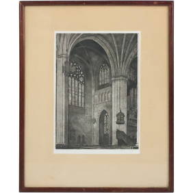
GEORGE A. BRADSHAW (Massachusetts, 1880-1968) Etching Cathedral Architecture, Pencil SignedDonny Malone Auctions4.4(1.8k)See Sold PriceMar 04, 2024
1887 Appletons' General Guide to the United State and Canada Part IIRail & Road Auctions4.6(165)See Sold PriceMar 08, 2024
Rand McNally & Co's New Ideal State and County Survey and Atlas 1911North American Artifact Auctions4.7(198)See Sold PriceApr 20, 2024
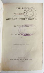
1859 LIFE OF GEORGE STEPHENSON RAILWAY ENGINEER by SAMUEL SMILES antiqueJasper524.5(9.9k)See Sold PriceFeb 27, 2024
TERRY BRADSHAW GEORGE BLANDA TARKENTON FOUTS JSA/COA SIGNED OFFICIAL NIKE JERSEYMynt Auctions4.6(697)See Sold PriceMar 01, 2024
Cooke, George 1801 Antique Map. United States of AmericaAlbion Auctions4.6(341)See Sold PriceMar 01, 2024
Cooke, George 1801 Antique Map. West Indies CaribbeanAlbion Auctions4.6(341)See Sold PriceMar 01, 2024
Cooke, George 1801 Antique Map. Sweden, Denmark, Norway, IcelandAlbion Auctions4.6(341)See Sold PriceMar 01, 2024
Cooke, George 1801 Antique Map. Germany divided into CirclesAlbion Auctions4.6(341)See Sold PriceMar 01, 2024
Cooke, George 1801 Antique Map. Italy, Sicily, Sardinia & CorsicaAlbion Auctions4.6(341)See Sold PriceMar 01, 2024