ATLAS of ANTIENT GEOGRAPHY by SAMUEL BUTLER 1843John McInnis Auctioneers,LLC4.6(502)See Sold PriceFeb 24, 2024
18TH C. ANTIQUE MAP: FRENCH & INDIAN WAR, FRAMEDThomaston Place Auction Galleries4.4(386)See Sold PriceFeb 24, 2024
Rand McNally Railroad Map Cabinet w/ 21 Railroad MapsRail & Road Auctions4.6(165)See Sold PriceMar 08, 2024
Keith Haring - Ink on New York Map, Best Buddies, Inscribed, Signed, and DatedSapphire Auction Gallery4(67)See Sold PriceMar 02, 2024
LATE 17TH C. FRENCH MAP OF THE NEW WORLD BY ALEXIS-HUBERT JAILLOT (1632-1712)Thomaston Place Auction Galleries4.4(386)See Sold PriceFeb 24, 2024
Central Railroad of New Jersey Map of Sandy Hook Route-ca. 1903JM Hobby Supply and Railroad Artifact Auctions4.4(126)See Sold PriceFeb 24, 2024
Lot of Six Mixed Atlas Box Cars-HO Scale-New in BoxJM Hobby Supply and Railroad Artifact Auctions4.4(126)See Sold PriceFeb 25, 2024
Rand McNally/Santa Fe Railroad Map of Iowa-1912JM Hobby Supply and Railroad Artifact Auctions4.4(126)See Sold PriceFeb 24, 2024
NICOLAES VISSCHER (NETHERLANDS, 1618-1709) MAP OF THE NEW WORLDThomaston Place Auction Galleries4.4(386)See Sold PriceFeb 24, 2024
17TH C. WORLD MAP BY NICOLAES VISSCHER (NETHERLANDS, 1618-1709)Thomaston Place Auction Galleries4.4(386)See Sold PriceFeb 24, 2024
Lot of Six Mixed Atlas Cabooses-HO Scale-New in BoxJM Hobby Supply and Railroad Artifact Auctions4.4(126)See Sold PriceFeb 25, 2024
Sold
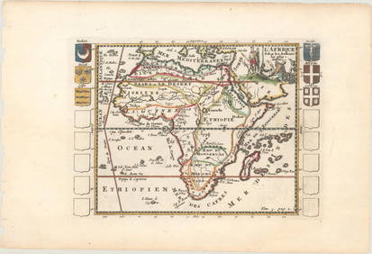
Blome's Africa Map from "Cosmography and Geography"A New Mapp of Africa. Richard Blome (1635-1705). Engraved map with original hand color. London, c. 1660. 16 x 21 inches sheet, 25 1/2 x 21 1/2 inches framed. Richard Blome (1635-1705) was a prolific LSee Sold Price
Sold17th Century Map of Africa[Africa or Libia Ulteriour...], by Richard Blome, after Sanson, published in [Cosmography and Geography], Bernhard Varenius, London, 1682, showing Northwestern Africa, elaborate heraldic cartouche witSee Sold Price
SoldBlome's World Map from "Cosmography and Geography"A Mapp of the Generall Carte of the World Designed in Two Plaine Hemispheres by Monsieur Sanson.. Richard Blome (1635-1705). Engraved map with original hand color. London, c. 1660. 16 x 21 inches sheeSee Sold Price
SoldBlome's Europe Map from "Cosmography and Geography"A New Mapp of Europe. Richard Blome (1635-1705). Engraved map with original hand color. London, c. 1660. 16 x 21 inches sheet, 25 1/2 x 21 1/2 inches framed. Richard Blome (1635-1705) was a prolific LSee Sold Price
SoldBlome's Asia Map from "Cosmography and Geography"Generall Mapp of Asia...Richard Blome (1635-1705). Engraved map with original hand color. London, c. 1660. 16 x 21 inches sheet, 25 1/2 x 21 1/2 inches framed. Richard Blome (1635-1705) was a prolificSee Sold Price
SoldBlome's N. America Map from "Cosmography and Geography"A New Mapp of America Septentrionale. Richard Blome (1635-1705). Engraved map with original hand color. London, c. 1660. 16 x 21 inches sheet, 25 1/2 x 21 1/2 inches framed. Richard Blome (1635-1705)See Sold Price
SoldBlome's S. America Map from "Cosmography and Geography"A New Mapp of America Meridionale. Richard Blome (1635-1705). Engraved map with original hand color. London, c. 1660. 16 x 21 inches sheet, 25 1/2 x 21 1/2 inches framed. Richard Blome (1635-1705) wasSee Sold Price
Sold1782 ATLAS MAPS Expilly Geography Voyages Travel World America Asia Africa1782 ATLAS MAPS Expilly Geography Voyages Travel World America Asia Africa Jean-Joseph Expilly was an 18th-century French geography and historian who published numerous works on cosmography, history oSee Sold Price
Blome: Map of Sacred Geography, 17531753 Map of Sacred Geography, Blome. 14 x 16.625. Copperplate map depicting the Biblical world and showing key locations mentioned in the Old and New Testaments. Inset of 'The Incampments of the IsraeSee Sold Price
Sold1780 VOYAGES 17 ATLAS Maps Geography Asia Africa Europe1780 VOYAGES 17 ATLAS Maps Geography Asia Africa Europe USA Vaugondy Collectors, of both maps and atlases, agree that Vaugondy maps are among the very best and most accurate maps! This collection of 1See Sold Price
Sold1780 VOYAGES 17 ATLAS Maps Geography Asia Africa Europe1780 VOYAGES 17 ATLAS Maps Geography Asia Africa Europe USA Vaugondy Collectors, of both maps and atlases, agree that Vaugondy maps are among the best and most accurate maps! This collection of 18th-cSee Sold Price
Sold1780 VOYAGES 17 ATLAS Maps Geography Asia Africa Europe1780 VOYAGES 17 ATLAS Maps Geography Asia Africa Europe USA Vaugondy Collectors, of both maps and atlases, agree that Vaugondy maps are among the very best and most accurate maps! This collection of 1See Sold Price
Sold1734 ATLAS Vaugondy MAPS Geography Asia Africa Europe1734 ATLAS Vaugondy MAPS Geography Asia Africa Europe USA France Germany Collectors, of both maps and atlases, agree that Vaugondy maps are among the best and most accurate maps! The collection of 18tSee Sold Price
Sold1833 Nubia & Abyssinia EGYPT Ethiopia Africa Missions1833 Nubia & Abyssinia EGYPT Ethiopia Africa Missions Geography MAP Bishop Michael Russell was a 19th-century historian who was well-versed in a variety of subjects, including Biblical and Holy Land hSee Sold Price
Sold1759 Geography 18 Maps ATLAS Africa Italy Asia America1759 Geography 18 Maps ATLAS Africa Italy Asia America California Island Buffier Known primarily for his contributions to philosophy, Claude Buffier, a 17th-century French Jesuit historian, publishedSee Sold Price
Sold1848 Houze ATLAS Geography 101 MAPS Europe Africa1848 Houze ATLAS Geography 101 MAPS Europe Africa America Hand-Colored England A rare 19th-century atlas filled with over 100 full-page maps hand-traced in color. These maps by Antoine Philippe HouzeSee Sold Price
Sold1711 MAPS Atlas Geography Africa Asia America1711 MAPS Atlas Geography Africa Asia America California Island France Buffier Claude Buffier was a 17th-century French historian who published works on metaphysics, grammar, and, most notably, univerSee Sold Price
Sold1782 Science & Astronomy Zodiac Cosmography Atlas MAPS1782 Science & Astronomy Zodiac Cosmography Atlas MAPS Geography Italian The first Italian edition of Chevigny’s “La Scienza” appeared in 1716. It covered many fields of knowledge including reliSee Sold Price
SoldSanson geography of Africa 18 mapsHeading: Author: Sanson, Nicolas Title: L'Afrique en plusieurs cartes novvelles, et exactes, & en divers traicte's de geographie, et d'histoire... Ses empires, ses monarchies, ses estats, &c., les moSee Sold Price
Sold1759 Barrow Geography Dictionary ATLAS MAPS Syria1759 Barrow Geography Dictionary ATLAS MAPS Syria Africa Coffee Tobacco HUGE FOLIO John Barrow was an 18th-century English naval historian remembered for his illustrated dictionaries. This tome from BSee Sold Price
Sold6 Maps published by Chapman & Hall, 1830-1842.[Mideast/Northern Africa/Ancient Geography]. 6 Maps. Prtd outline color. ++ The World As Known To The Ancients. Uses information from Hanno, Pliny, and Ptolemy. In margin at lower right: “Drawn by RSee Sold Price
Sold1770 VOYAGES Geography 17 ATLAS Maps Jesuits Asia Afric1770 VOYAGES Geography 17 ATLAS Maps Jesuits Asia Africa Europe USA Astronomy Collectors, of both maps and atlases, agree that Vaugondy maps are among the very best and most accurate maps! This collecSee Sold Price
SoldRelief maps of continents with box, c.1880Heading: Author: Ravenstein, August Title: Embossed Atlas for Elementary Instruction in Physical Geography. Containing Maps of Europe, Asia, Africa, North America, South America, Australasia and PolySee Sold Price
Sold1753 Map of Sacred Geography by BlomeReserve Reduced! Copperplate map depicting the Biblical world and showing key locations mentioned in the Old and New Testaments. Inset of 'The Incampments of the Israelites in the Desart.” FascinatiSee Sold Price
CHARLES ROLLIN c1828 Ceasar Hand Colored Africa Military MapLuis Porretta Fine Arts4.3(10)See Sold PriceMar 02, 2024
1849 Mitchell School ATLAS 24 MAPS America Holy Land France Africa Egypt AsiaSchilb Antiquarian Rare Books4.8(421)See Sold PriceMar 31, 2024
Chatelain - Map of the Americas and Details and Insets of Government CounselsTrillium Antique Prints & Rare Books4.5(30)See Sold PriceFeb 24, 2024
Chatelain - 3 Maps of the British Isles (England, Ireland, Scotland)Trillium Antique Prints & Rare Books4.5(30)See Sold PriceFeb 24, 2024
AFRICA. Map pre-dating much exploration. Mountains of Kong. SDUK 1851 oldJasper524.5(9.8k)See Sold PriceFeb 28, 2024
AFRICA. Africa. General Map; Inset map of Population map 1907 old antiqueJasper524.5(9.8k)See Sold PriceFeb 28, 2024
AFRICA. Political Map of showing International Boundaries 1936 old vintageJasper524.5(9.8k)See Sold PriceFeb 28, 2024
Carte de L'Algérie et de la Régence de Tunis' ANDRIVEAU-GOUJON Algeria 1850 mapJasper524.5(9.8k)See Sold PriceFeb 28, 2024
Central Africa. Map showing great forest traversed by Mr Stanley, 1890Jasper524.5(9.8k)See Sold PriceFeb 28, 2024