SoldBleau (Willem Janszoon) Group of 5 regional mapsBleau (Willem Janszoon) Group of 5 regional mapsshowing regions of France, with decorative title cartouches and figures, engraved maps, with original hand-colouring, each 390 x 510mm., some brSee Sold Price
FFRAN Bleau (Willem Janszoon) Group of 5 regionalFFRAN Bleau (Willem Janszoon) Group of 5 regional mapsshowing regions of France, with decorative title cartouches and figures, engraved maps, with original hand-colouring, each 390 x 510mm., sSee Sold Price
SoldGrp: 4 Regional Maps Blaeu OrteliusGroup of four hand colored regional maps. Includes three maps by Willem Janszoon Blaeu (1571-1638), "Prima pars Brabantiae cuius caput Lovanium," a map depicting Tienen and Leuven in Belgium, and "ComSee Sold Price
SoldBlaeu French Regional Map, 17th C.Les Souverainetez de Sedan et de Raucourt et la prevosté de Doncheri. Willem Janszoon Blaeu (1571-1638). Joan Blaeu (1596-1673). Amsterdam: Mid 17th Century. Hand-colored engraving19 3/4 x 24 inchesSee Sold Price
SoldMap, "Tractus Borysthenis Vulgo Dniepr", BlaeuMap, "Tractus Borysthenis Vulgo Dniepr", map of the lower part of the Dniepr River, extending to the Black Sea. Margins ripped, pieces missing, 21.5" by 25.5", Willem Janszoon Blaeu, Amsterdam circa 1See Sold Price
SoldGrp: 3 Maps Eastern Europe Ukraine Romania BlaeuGroup of three maps of Eastern Europe. Includes one map of Walachia, Serbia, Bulgaria, and Romania by Willem Janszoon Blaeu (1571-1638); one map of Slovenia, Croatia, and Bosnia by Blaeu after GerarduSee Sold Price
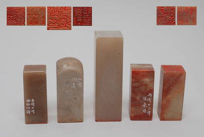
SoldNova Belgica et Anglia Nova. [Bleau, 1635-1663].[American East Coast]. Nova Belgica Et Anglia Nova. Double-page map by Willem Janszoon Bleauw after a manuscript map by Adriaen Block, showing the coast from south of the Chesapeake Bay to “Novae FrSee Sold Price
SoldBlaeu Ethiopia Map ca. 1660sWillem Janszoon Blaeu (1571-1638), "Aethiopia Superior vel Interior vulgo Abissinorum sive Presbiteri Ioannis Imperium," Amsterdam, ca. 1662-5. This hand colored map of Ethiopia and the surrounding arSee Sold Price
SoldMOLUCCAS - BLAEU, Willem Janszoon.MOLUCCAS - BLAEU, Willem Janszoon. Molvccae Insvlae Celeberrimae. (Amst., Willem & Johan Blaeu, 1635). (Ca. 37,5 x 48,5 cm). Hand-coloured engraved map of Molucca Islands Machian, Timor, 'PottebackersSee Sold Price
SoldHand Colored 'Belgium, The Netherlands, Limburg' MapHand Colored 'Belgium, The Netherlands, Limburg' Map 1662, mapped within the geographical coordinates, published in Amsterdam by Willem Janszoon Blaeu and Joan Blaeu Height: 5.50 inches, Width: 20.00See Sold Price
SoldBleau Map of AsiaBLAEU, Willem Janszoon (1571-1638). Asia Noviter Delineata…Engraved map with original hand color. Amsterdam, c. 1618-1650. 20 x 24 inches sheet, 25 1/8 x 21 3/8 inches framed This is one of the mostSee Sold Price
Blaeu: Antique Map of Italy & Islands, 1635Title: "Nova Italiae Delineatio", Beautiful mid-17th century hand-colored map of Italy and surrounding islands Map maker: Willem Janszoon Blaeu Place and Year: Amsterdam, c. 1635 Dimensions: 51.0 x 59See Sold Price
SoldEarly American East Coast Map, Willem BleauWillem Janszoon Blaeu (Dutch, 1571-1638). Two conjoined pages to form the single map depicting New Netherlands and New England, with Manhattan and the coast of Long Island. Embellished with ships, figSee Sold Price
SoldGROUPING OF (4) ANTIQUE MAPSItaly, Cremona; Willem Janszoon & Joan Blaeu -Territorio Di Cremona - 1644. Hand color engraving on paper. Dimensions: H 20.5" x W 24" Condition: Some folds and paper loss in the center, tears and watSee Sold Price
(3) MAPS, BLAEU CHILI, GROELAND, ARROWSHITH CHILI(lot of 3) Framed maps: (1) "Partie du Groeland", 1827, Philippe Vandermalen (Belgium, 1795-1869), sight: 19"h, 22.5"w, overall: 30"h, 31"w; (1) "Chili", c. 1830, Willem Janszoon Blaeu (Dutch, 1570-16See Sold Price
SoldBLAEU'S ANTIQUE MAP OF THE BRITISH ISLESHand coloured map entitled Magnae Britanniae et Hiberniae Tabula by Willem Janszoon Blaeu. Amsterdam, circa 1650. Image size: 15 1/2 x 19 1/2 in. (39 x 49.5 cm.) Has not been examined out of the glassSee Sold Price
SoldMap "Nova Virginia Tabula" 17th century.Hand Colored map, by Willem Janszoon Blaeu. Amsterdam C. 1640, hand colored. Plate size 18.75" x 14 5/8", visible plate bite beyond those measurements. A very important and early map of the United StaSee Sold Price
SoldVintage Map, Willem Janszoon Blaeu, Virginae PartisWillem Janszoon Blaeu (Dutch, 1571-1638) "Virginiae Partis Australis, et Floridae," copper engraved map, image: 15"h x 20"w, overall (with frame): 18.5"h x 23"wSee Sold Price
SoldWILLEM JANSZOON BLAEU (Dutch 1571-1638) A hand coWILLEM JANSZOON BLAEU (Dutch 1571-1638) A hand colored engraved map of Britannia - mid 17th century. 15.5"x20.75" (39.5cm x 53cm) (plate size). Estimate $300-$500See Sold Price
SoldBleau Map of the American North EastNova Belgica et Anglia Nova. Willem Janszoon Blaeu (1571-1638) and Johannes Blaeu (1596-1673). Engraved map with original hand color in part. Amsterdam, 1635-1667. 20 x 23 1/2 inches sheet, 29 1/2 x 3See Sold Price
Sold1654 Map of Southwest Scotland by Willem JanszoonBlaeu, Amsterdam. Titled "Gallovidiae Pars Media que Deam et Cream fluvios interjacet...." Dimensions: 16.5" h x 21.5" w. Condition: Damp stains top right and left corners margins. paper toned, just iSee Sold Price
North German Antique Map by JanszoonMade by Willem Janszoon; titled "Pomeraniae Ducatus Tabula"; published by Atlas Maior sive Cosmographia, Amsterdam, 1650; measures approximately 14.8" x 19.5"; hand watercolor; in Good condition; handSee Sold Price
1635 Europa Recens DescriptaBy: Willem Janszoon Blaeu Date: 1635 (published) Amsterdam Dimensions: 16 x 22 inches (40.5 x 56 cm) This is a fine example of Blaeu’s iconic map of Europe produced during the golden age of DutcSee Sold Price
1642 Americae Nova TabulaBy: Willem Janszoon Blaeu Date: 1642 (published) Amsterdam (4th State) Dimensions: 16 x 22 inches (40.5 x 56 cm) This is one of the few maps of the Americas by this famous Dutch cartographer. The mapSee Sold Price
WILLEM JANSZOON BLAEU (NETHERLANDS, 1571-1638) MAP OF UMBRIAThomaston Place Auction Galleries4.4(393)See Sold PriceFeb 24, 2024
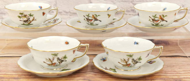
Group Lot of 5 Herend Rothchild Teacups and SaucersBodnar's Auction Sales4.5(615)See Sold PriceMar 06, 2024
Willem Blaeu, Etc. 17th C. Antiquarian Maps, 2Auctions at Showplace4.6(740)See Sold PriceMar 17, 2024
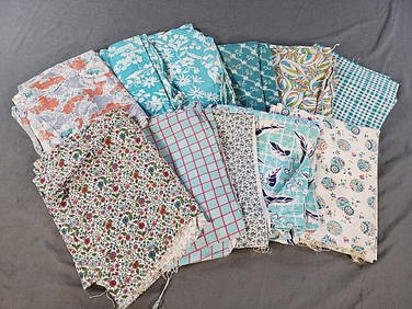
[BLACK POWER]. A group of 5 Black Power blacklight/Day-Glo posters, comprising:Freeman's | Hindman4.4(1.6k)See Sold PriceFeb 27, 2024
Group of 5 Vintage Hunters Pocket KnivesMatthew Bullock Auctioneers4.7(1.8k)See Sold PriceFeb 24, 2024
Group of 5 1933-34 Chicago Worlds Fair Souvenir CompactsMatthew Bullock Auctioneers4.7(1.8k)See Sold PriceFeb 24, 2024
Group of 5 1934 Sinclair Graphic Road MapsCheck the Oil Promotions, LLC4.6(327)See Sold PriceMar 03, 2024
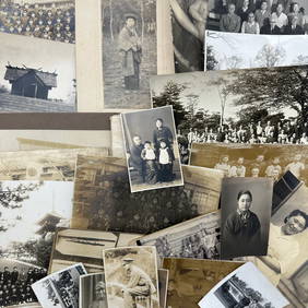
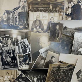
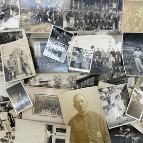
Photography - Set of 30 Photos from Japan - Group photographs - Military photographsProverde Auctions4.3(3)See Sold PriceFeb 28, 2024
Photography - Set of 30 Photos from Japan - Group photographs - LandscapesProverde Auctions4.3(3)See Sold PriceFeb 28, 2024
Photography - Set of 30 Photos from Japan - Group photographs and portraits of Japanese peopleProverde Auctions4.3(3)See Sold PriceFeb 28, 2024


![Nova Belgica et Anglia Nova. [Bleau, 1635-1663]. (1 of 4)](https://p1.liveauctioneers.com/179/47316/21802625_1_x.jpg?height=282&quality=70&version=1383851649)


![[BLACK POWER]. A group of 5 Black Power blacklight/Day-Glo posters, comprising: (1 of 5)](https://p1.liveauctioneers.com/197/319238/171467921_1_x.jpg?height=282&quality=70&version=1707520367)