SoldBLAIR, JOHN. A Map of North America from the LBLAIR, JOHN. A Map of North America from the Latest Surveys and Maps. Double-page engraved map engraved by Thomas Kitchin, 425x590 mm, wide margins; nicely hand-colored. McCorkle 728.2. London, 1768See Sold Price
SoldBlair - Map of North America, 1768[A Map of North America from the Latest Surveys and Maps by John Blair, L.L.D. & F.R.S. as a Supplement to His Tables of Chronology], from Thomas Kitchins, [A General Atlas], (London, 1768), hand coloSee Sold Price
SoldBLAIR, JOHN. A Map of North America.BLAIR, JOHN. A Map of North America. Engraved folding map, 430x600 mm, wide margins; nicely hand-colored. London, 1768 Very lovely map and rarely seen. All items are offered for sale subject toSee Sold Price
SoldA Map of North America by John BlairMaps“A Map of North America” by John Blair, 1794--Identifying Indian Nations ! 1794, “A MAP OF NORTH AMERICA FROM THE LATEST SURVEYS AND MAPS,” by John Blair, Engraved by ThomaSee Sold Price
SoldA Map of North America by John BlairMaps“A Map of North America” by John Blair, 1794--Identifying Indian Nations ! 1794, “A MAP OF NORTH AMERICA FROM THE LATEST SURVEYS AND MAPS,” by John Blair, Engraved by ThomaSee Sold Price
SoldA Map of North America by John BlairMaps“A Map of North America” by John Blair, 1794--Identifying Indian Nations ! 1794, “A MAP OF NORTH AMERICA FROM THE LATEST SURVEYS AND MAPS,” by John Blair, Engraved by ThomaSee Sold Price
SoldJohn Blair (1722-1782, British), "A Map of NorthJohn Blair (1722-1782, British), "A Map of North America, hand colored, H. - 18 in., W. - 22 3/4 in.See Sold Price
SoldJ. Blair Map of North AmericaA Map of North America, Published by John Blair, LLD & FRS, c. 1779. Engraved map, "From the Latest Surveys and Maps by John Blair LLD & FRS as a Supplement to His Tables of Chronology", engraved by TSee Sold Price
De Vaugondy (Gilles Robert) Partie de l'Amerique SDe Vaugondy (Gilles Robert) Partie de l'Amerique Septentrionale, qui Comprend le Cours de l'Ohio ...,map of the British colonies, based upon John Mitchell's map of North America from the sameSee Sold Price
SoldGeneral Map of North America...John Reid & W. Winterbotham. from the American Atlas. New York: J. Reid, L. Wayland & C. Smith, 1796. Engraved Map with Orignal Hand-color in Outline. 16 1/2 x 20 inchesSee Sold Price
(19th c.) Map of North AmericaL'Amerique Septentrionale with 17th century features Condition: toning Size: 11" x 8"toning11" x 8"See Sold Price
SoldSpanish Dominions of N. Amer. Map, 1818 Pinkerton"Spanish Dominions of North America. Northern Part" map, drawn under the direction of Mr. John Pinkerton by L. Hebert, engraved by Samuel John Neele, published by Thomas Dobson & son, Philadelphia, 18See Sold Price
SoldMcKENNEY, THOMAS L. AND JAMES HALL The Indian TriMcKENNEY, THOMAS L. AND JAMES HALL The Indian Tribes of North America Plates, some in color, and maps. 3 vols. 8vo, cloth. Covers lightly spotted. Edinburgh: John Grant, 1933-1934.See Sold Price
McKenney Hall Indian Tribes America Maps NativeThomas L. McKenney & James Hall, ''The Indian Tribes of North America With Biographical Sketches and Anecdotes of the Principal Chiefs.'' Edited by Frederick Webb Hodge; Edinburgh; John Grant, 1933-34See Sold Price
SoldTallis, John (Pub) 1852 Map. North AmericaSteel Engraved Map with Original Outline Hand Color Published 1852-56 by John Tallis, London for "The Universal Pronouncing Dictionary" by Thomas Wright. Drawn & Engraved by John Rapkin. Centre fold aSee Sold Price
SoldJohn Senex Map of North AmericaBritish, 18th century, black and white printing with minimal colored highlights, decorative cartouche in upper left, 40 x 27 in.; framed 44 x 31-1/2 in.See Sold Price
SoldWalker, John 1795 Map of North America. USA CanadaCopper Engraved Map Published 1795, London for "Elements of Geography, and of Natural and Civil History" by John Walker. Centre fold as published. Paper Size: 10 x 8.5 inch (26 x 22cm) Split on centreSee Sold Price
SoldJohn Senex Map of North AmericaBritish, 1710, North America Corrected From The Observations Communicated To The Royal Society, decorative cartouche in upper left, engraving with hand colored highlights, on laid paper, 40 x 27 in.;See Sold Price
SoldJohn Grigg: Map of North America, 1830Map: North America Maker: John Grigg, Malte-brun, Conrad/ J. H. Young Date: 1830 Size: Quarto, 9.8 inches high x 8 inches wide From Malte-Brun's "A new General atlas, exhibiting the five great divisioSee Sold Price
Sold1806 John Carey Map of North AmericaDESCRIPTION: 1806 John Carey A New Map of Part of the United States of North America in two parts. Handcolored engraving on wove paper. MEASUREMENTS: 20-7/8" x 25" CONDITION: Hinged at center. Two minSee Sold Price
SoldJohn Cary Map of North America 1806John Cary, "A New Map of North America from the Latest Authorities", London, 1806, hand-colored engraved map, showing the U.S. after the Louisiana Purchase and before the exploration by Lewis & Clark,See Sold Price
JOHN REID - MAP OF NORTH AMERICA, 1796John Reid - Map Of North America, 1796 - 36 X 28 3/4 In. - This Giclée Print Is Gallery Stretched And Ready To Hang Or Lean Against A Wall, Or Display On An Easel. - A Giclée Print Is The Highest QuSee Sold Price
JOHN REID - MAP OF NORTH AMERICA, 1796John Reid - Map Of North America, 1796 - 36 X 28 3/4 In. - This Giclée Print Is Gallery Stretched And Ready To Hang Or Lean Against A Wall, Or Display On An Easel. - A Giclée Print Is The Highest QuSee Sold Price
John Reid - Map Of North America, 1796John Reid - Map Of North America, 1796 Size: 36 X 28 3/4 In. - This Is A Gallery Stretched Giclee Print On Canvas. The Piece Was Printed On High Quality Artist Grade 350 Gsm, Acid-free, Archival CanvaSee Sold Price
Mckenney & Hall - Two Octavo Volumes of Text with Rare Plate of Billy BowlegsTrillium Antique Prints & Rare Books4.5(30)See Sold PriceFeb 24, 2024
McKenney & Hall, Folio, Rare - 5 Native American LithographsTrillium Antique Prints & Rare Books4.5(30)See Sold PriceFeb 24, 2024
McKenney & Hall, Folio, Rare - Se-Quo-YahTrillium Antique Prints & Rare Books4.5(30)See Sold PriceFeb 24, 2024
McKenney & Hall, Folio, Rare - Hunting the BuffaloeTrillium Antique Prints & Rare Books4.5(30)See Sold PriceFeb 24, 2024
Audubon - 8 Quadruped LithographsTrillium Antique Prints & Rare Books4.5(30)See Sold PriceFeb 24, 2024
Audubon, Imperial Folio - American Cross Fox. 6Trillium Antique Prints & Rare Books4.5(30)See Sold PriceFeb 24, 2024
Audubon, Imperial Folio - Canada Lynx. 16Trillium Antique Prints & Rare Books4.5(30)See Sold PriceFeb 24, 2024
Karl Bodmer - A Young Mandan Indian. 24Trillium Antique Prints & Rare Books4.5(30)See Sold PriceFeb 24, 2024
Karl Bodmer - Assinboin Indians. 32Trillium Antique Prints & Rare Books4.5(30)See Sold PriceFeb 24, 2024
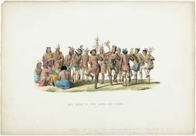
Karl Bodmer - Scalp Dance of the Minatarres. 27Trillium Antique Prints & Rare Books4.5(30)See Sold PriceFeb 24, 2024
Map: An 18thC engraved and hand coloured map of North America and South America, titled DeClaydon Auctioneers Ltd4.3(125)See Sold PriceFeb 26, 2024
First 50 plates from Audubon's Quad Quarto (all in Vol. I)PBA Galleries4.7(381)See Sold PriceMar 07, 2024
Italian edition of Sanson's map of North America, 1677PBA Galleries4.7(381)See Sold PriceMar 07, 2024