Bellin map of Hudson's Bay 1753Title: Carte des Parties du Nord-Ouest de l'Amerique Suivant les Voyages de Middleton et d'Ellis en 1742 et 1746. Pour Chercher un Passage dans la Mer du Sud Author: Bellin, Jacques Nicolas DescriptioSee Sold Price
Bellin map of Hudson's Bay 1753Title: Carte des Parties du Nord-Ouest de l'Amerique Suivant les Voyages de Middleton et d'Ellis en 1742 et 1746. Pour Chercher un Passage dans la Mer du Sud Author: Bellin, Jacques Nicolas DescriptioSee Sold Price
Bellin map of Hudson's Bay 1753Title: Carte des Parties du Nord-Ouest de l'Amerique Suivant les Voyages de Middleton et d'Ellis en 1742 et 1746. Pour Chercher un Passage dans la Mer du Sud Author: Bellin, Jacques Nicolas DescriptioSee Sold Price
SoldBellin: Antique Map of Hudson Bay Region, 1753Title/Content of Map: Carte des Parties du Nord-Ouest de l'Amerique Cartographer: Bellin Place & Date: Paris / 1753/1760 Size: 10 3/4" x 8 1/8" Condition: b&w; overall age toning; a small repaired punSee Sold Price
Soldc1757 Bellin Map of Hudson's BayA nicely engraved map of Jacques Bellin circa 1757 entitled "Carte De La Baye De Hudson", Very Good, trim to right margin, measures 13.75 x 9.5". Reserve: $70.00 Shipping: Domestic: Flat-rate of $5.00See Sold Price
Sold1757 Bellin Map of Hudson Bay and Labrador -- Carte deTitle/Content of Map: 1757 Bellin Map of Hudson Bay and Labrador -- Carte de la Baye de Hudson Date: 1757, Paris Cartographer: J Bellin Size: 8.5 x 11.8 in. This is a very nice map of Hudson Bay and LSee Sold Price
c1757 Bellin Map of Hudson's BayA nicely engraved map of Jacques Bellin circa 1757 entitled "Carte De La Baye De Hudson", Very Good, trim to right margin, measures 13.75 x 9.5". Reserve: $70.00 Shipping: Domestic: Flat-rate of $5.00See Sold Price
c1757 Bellin Map of Hudson's BayA nicely engraved map of Jacques Bellin circa 1757 entitled "Carte De La Baye De Hudson", Very Good, trim to right margin, measures 13.75 x 9.5". Reserve: $70.00 Shipping: Domestic: Flat-rate of $5.00See Sold Price
1757 Bellin Map of Hudson Bay and Labrador -- Carte deTitle/Content of Map: 1757 Bellin Map of Hudson Bay and Labrador -- Carte de la Baye de Hudson Date: 1757, Paris Cartographer: J Bellin Size: 8.5 x 11.8 in. This is a very nice map of Hudson Bay and LSee Sold Price
SoldBellin: Map of Hudson Bay, 1757Map: Carte de la Baye de Hudson Cartographer: Bellin Place & Date: Paris / 1757/1760 Size: 11 7/8" x 8 5/8" Condition: b&w; a small repaired puncture hole in the lower left quadrant (with slight lossSee Sold Price
1757 Bellin Map of Hudson Bay and Labrador -- Carte deTitle/Content of Map: 1757 Bellin Map of Hudson Bay and Labrador -- Carte de la Baye de Hudson Date: 1757, Paris Cartographer: J Bellin Size: 8.5 x 11.8 in. This is a very nice map of Hudson Bay and LSee Sold Price
1757 Bellin Map of Hudson Bay and Labrador -- Carte deTitle/Content of Map: 1757 Bellin Map of Hudson Bay and Labrador -- Carte de la Baye de Hudson Date Printed: 1757, Paris Cartographer: J Bellin Size: 8.5 x 11.8 in. This is a very nice map of Hudson BSee Sold Price
SoldBellin: Antique Map of Hudson Bay, 1770Map: Hudson Bay Date Printed: 1770 Cartographer: N. Bellin Material/Medium: Paper Size: 12 3/4" x 9 1/2" Rare Map. Printed in Paris. From the Atlas Portrait Jacques-Nicolas Bellin(1703-1772) was a FreSee Sold Price
SoldBellin: Antique Map of Hudson Bay, Canada, 1757Title/Content of Map: 'Carte de la Baye de Hudson' Hudson Bay. Canada Date Printed: 1757 Image Size: Approx 24.0 x 33.5cm, 9.25 x 13 inches (Large); Please note that this is a folding map. Type: AntiqSee Sold Price
SoldBellin: Antique Map of Canada's Hudson Bay & LabradorTitle/Content of Map: Canada's Hudson Bay & Labrador Date Printed: c 1740-70's Cartographer: J.N. Bellin & J.F. La Harpe Material/Medium: Paper Size: 14 1/4" x 10" Copperplate engraved. Published in PSee Sold Price
Sold2 Maps incl Carte ds Bayes, Rades et Port...[1744][Newfoundland/Hudson Bay Region]. 2 Maps by Jacques Nicolas Bellin. Both from Charlevoix’s “Histoire et Description Generale de la Nouvelle France,” [1744]. Sabin 12135. ++ Carte des Bayes, RadeSee Sold Price
SoldEARLY MAP OF THE HUDSON BAYEarly copper-engraved and hand-colored map of the Hudson Bay, 14" x 9 1/2", printed in 1753 by a French publisher. Titled "Carte des Parties du Nord-Ouest de l'Amerique", the map shows the northern poSee Sold Price
Carte des Parties du Nord-Ouest... 1753.[North/Canada/Hudson Bay]. Bellin. Carte des Parties du Nord-Ouest de l’Amerique Suivant les Voyages de Middleton et d Ellis en 1742 et `1746. Pour chercher un Passage dans la Mer du Sud. Par M. B.See Sold Price
SoldEARLY MAP OF THE HUDSON BAYEarly copper-engraved and hand-colored map of the Hudson Bay, 14 in. x 9 1/2 in., printed in 1753 by a French publisher. Titled 'Carte des Parties du Nord-Ouest de l'Amerique", the map shows the northSee Sold Price
SoldAntique Map - Map of Canada - Hudson Bay - Labrador - Arctic Ocean - AmericasThis fine engraving map of Canada by Jacques-Nicolas Bellin originates from "Histoire générale des voyages..." by Antoine François Prévost d'Exiles in 1757. The author depicts Hudson's BaySee Sold Price
Bellin, Jaques Nicolas. Carte de la Baie de HudsonBellin, Jaques Nicolas Carte de la Baie de Hudson 1774 Copperplate engraving; outline coloured Printed area: 49.1 x 38 cm; 19.3 x 14.9 in Chart of Hudson Bay and Labrador with depictions of the mountaSee Sold Price
SoldHomann (Heirs of) - Partie Orientale de la Nouvelleafter Bellin, from Hudson Bay and Lake Ontario to Newfoundland, large decorative title cartouche lower right, engraved map, 450 x 560mm., central vertical fold, Nuremberg, 1755 § Holland (Samuel)See Sold Price
SoldMap: Hudson's Bay in North America, 1782, J. BewA framed map: New and Accurate Chart of Hudson's Bay in North America. Published, London Nov. 1782, By J. Bew, Pater Noster Row. Hand colored map, sight measurement 7.25" x 9.25". Framed and matted unSee Sold Price
SoldDiderot Map (Hudson Bay) 1751 - 1780Diderot Map (Hudson Bay) 1751 - 1780. Measures 11.5" x 13.5" image size and 16" x 8.75" sheet size. Creased at fold lines. Unframed, loose and not glued or mounted. Provenance: C.D. Raymond & Son collSee Sold Price
LARGE LATE 17TH C. DUTCH CHART OF CANADA, GREAT LAKES, NEW FRANCE, LABRADOR, HUDSON BAY, BY PIERREThomaston Place Auction Galleries4.4(386)See Sold PriceFeb 24, 2024
1764 Bellin Map of Lesser Antilles Northern Portion -- Petites Antilles ou Isles du Vent 3e. Partie.Jasper524.5(9.8k)See Sold PriceFeb 27, 2024
1764 Bellin Map of Eastern Guadeloupe in the Lesser Antilles -- Partie Orientale de l'Isle de laJasper524.5(9.8k)See Sold PriceFeb 27, 2024
1764 Bellin Map of Mari-Galante Near Guadeloupe -- Carte de l'Isle de Mari-GalanteJasper524.5(9.8k)See Sold PriceFeb 27, 2024
1764 Bellin Map of St. Kitts -- Carte de l'Isle St. ChristopheJasper524.5(9.8k)See Sold PriceFeb 27, 2024
1764 Bellin Map of Southern Portion of Martinique -- Partie Meridionale de la MartiniqueJasper524.5(9.8k)See Sold PriceFeb 27, 2024
1764 Bellin Map of Antigua -- Carte de l'Isle d'Antigue Situee par la Latitude 17 Degres et par laJasper524.5(9.8k)See Sold PriceFeb 27, 2024
1764 Bellin Chart of Three South Haitian Bays -- Carte des Bayes du Mesle des Flamands et deJasper524.5(9.8k)See Sold PriceFeb 27, 2024
1764 Bellin Map of Fort Louis Area of Guadeloupe -- Environs du Fort Louis de la GuadeloupeJasper524.5(9.8k)See Sold PriceFeb 27, 2024
1764 Bellin Map of Port Antonio, Jamaica -- Plan des Havres de Port Antonio et de Saint FrancoisJasper524.5(9.8k)See Sold PriceFeb 27, 2024
Coste Occidentale d’Afrique…' Arguin Bay Cap Blanc Mauritania. BELLIN 1746 mapJasper524.5(9.8k)See Sold PriceFeb 28, 2024
Plan de la Baye & Isle d'Arguim'. Mauritania. Arguin island. BELLIN 1746 mapJasper524.5(9.8k)See Sold PriceFeb 28, 2024
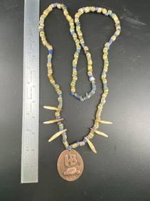
Hudson Bay Necklace with Trade Beads Indian Artifact ArrowheadMike Nichols Auctions4.4(456)See Sold PriceMar 03, 2024
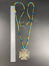
Hudson Bay Cross with Trade Beads Indian Artifact ArrowheadMike Nichols Auctions4.4(456)See Sold PriceMar 03, 2024
Jacques Nicolas Bellin - View of the entrance to Zihuatanejo Bay - View of the entrance to the portProverde Auctions4.3(3)See Sold PriceFeb 28, 2024
Robert de Vaugondy - Map of Canada - Mer de l' Ouest or Sea of the West and a Northwest PassageProverde Auctions4.3(3)See Sold PriceFeb 28, 2024
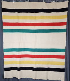
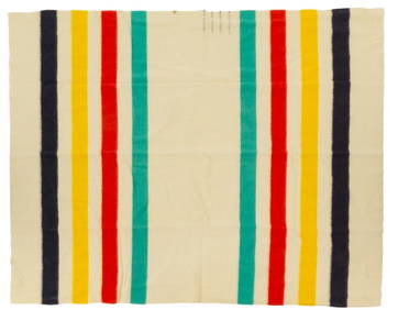
Hudson Bay Co. Wool Blanket, 7 ft. 8 in. x width 6 ft.Vogt Auction Texas4.5(597)See Sold PriceFeb 24, 2024
Lionel LTI 6-27617 Deleware & Hudson Bay Window Caboose w/ OBGregory Hake Auctions4.5(61)See Sold PriceMar 06, 2024


![2 Maps incl Carte ds Bayes, Rades et Port...[1744] (1 of 3)](https://p1.liveauctioneers.com/179/41615/18011226_1_x.jpg?height=282&quality=70&version=1369948904)